
"It's so high, that...."
Posted on 12/08/2020 7:59:13 AM PST by rickmichaels
KATHMANDU — Mount Everest is higher than previously thought, Nepal and China said on Tuesday, settling a long-running conflict over the height of the world’s tallest peak that straddles their shared border.
Kathmandu and Beijing had differed over its exact height but after each sent an expedition of surveyors to the summit they have agreed that the official height is 8,848.86 metres (29,031.69 feet), a bit more than their previous calculations.
Everest is an “eternal symbol of … friendship between Nepal and China,” said Nepali Foreign Minister Pradeep Kumar Gyawali, announcing the findings of their surveys on a video call with his Chinese counterpart Wang Yi.
Nepal had never previously measured the height of Mount Everest on its own but had used the 8,848 meters (29,028 feet) estimate made by the Survey of India in 1954 that includes snow.
A Chinese measurement in 2005 determined that the rock height of the summit was 8,844.43 meters (29,017 feet), about 3.7 meters (11 feet) less than the 1954 estimate.
(Excerpt) Read more at nationalpost.com ...
My dad flew the Hump in the China-Burma-India Campaign.
He could’ve confirmed the number...
Mt.Everest is also a big source of tourism dollars, from what I heard. You have to buy a hiking permit to go up there. There are many guides for hire, to go with you, who make money from Mt. Everest tourism.
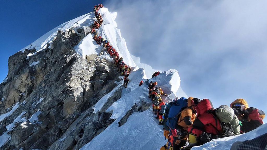
I recall a while back, seeing pictures with a line of people waiting to get up to the top of Mt. Everest. Who knew at the top of the world, that you have to line up to get there?
Sadly there are dead bodies up there too, because it’s dangerous to go hiking in that environment, and some don’t come out alive.
"It's so high, that...."
Given that the Indian subcontinent is still ramming up China’s butt, it’s not unlikely that the Himalayas have been thrust up another few meters.
“Mount Everest is higher than previously thought, say Nepal and China”
really huh?
“The supposed Mount Everest is falsely claimed higher than supposedly thought by unconfirmed right wing extremists from Nepal and China”

Well, since they relaxed the marijuana laws...
There are some smart business people in Nepal...

I recall a while back, seeing pictures with a line of people waiting to get up to the top of Mt. Everest. Who knew at the top of the world, that you have to line up to get there?
_______________
That there is so much wealth in the world, that people would be able to line up.
There are many guides for hire, to go with you, who make money from Mt. Everest tourism.
= = =
I’ll bet they don’t have their Gigs taxed, like the Lyft and Uber situation.
I guess they never heard of or asked NASA or another foreign space agency to task a satellite to determine the exact height...
On a similar note, several years ago a watched a documentary on Everest and the focus was on the discovery that it is the tallest in the world. This was done by surveyors in the late 1800’s that were surveying what was then India. It was fascinating as the survey team had to use wood rods and chains to and had to make some pretty intense calculations for expansion and contraction due to the heat and humidity.
They were using K2, Everest, and another mountain peak for triangulation / trig leveling, to determine elevations and as they progressed through the country is when they determined that Everest was the tallest, when they originally thought it was K2.
“the rent is to damn high”
“...and our stock will go high!”
Above what? in other words what is the base? sea level?
if seas are rising ..... height above should be decreasing.
Height is measured from one of two references, the ellipsoid or the geoid. The geoid represents a surface of uniform gravitational potential, representing a putative mean sea level. In the absence of tidal influences, it is the level at which seas would be at rest. Inland, one can think of the geoid as the level of a well connected by a [very, very long] pipe to the ocean. The geoid accounts for irregularities in the distribution of mass in real world. It is not so important that the geoid is at the exact level of the real ocean, as that it is an equipotential surface.
The ellipsoid is an arbitrary figure representing the “average” figure of a geoid, useful for navigation. The most popular ellipsoid these days is WGS-84, which is the basis of GPS navigation. The ellipsoid is defined by its equatorial and polar radii, and the location of the poles. For navigation, a conventional meridian connecting poles is defined, which for WGS-84 is near the old prime meridian of Greenwich.
The article is not at all clear, and the deviation of the geoid from the ellipsoid in the Indian subcontinent is large, in the range of 60-80 below the ellipsoid in the region of the Himalayas.
https://en.wikipedia.org/wiki/Geoid
As they absolutely should have.
I was going to climb it, but now maybe it’s too high.
Until it isn't...
I suspect that's a gem China will seek to own at some point.
Disclaimer: Opinions posted on Free Republic are those of the individual posters and do not necessarily represent the opinion of Free Republic or its management. All materials posted herein are protected by copyright law and the exemption for fair use of copyrighted works.