Free Republic
Browse · Search
News/Activism
Topics · Post Article

Skip to comments.

Hurricane Irma Live Thread
NHC/NOAA ^ | NHC/NOAA | NHC/NOAA

Posted on 09/04/2017 2:02:19 PM PDT by NautiNurse

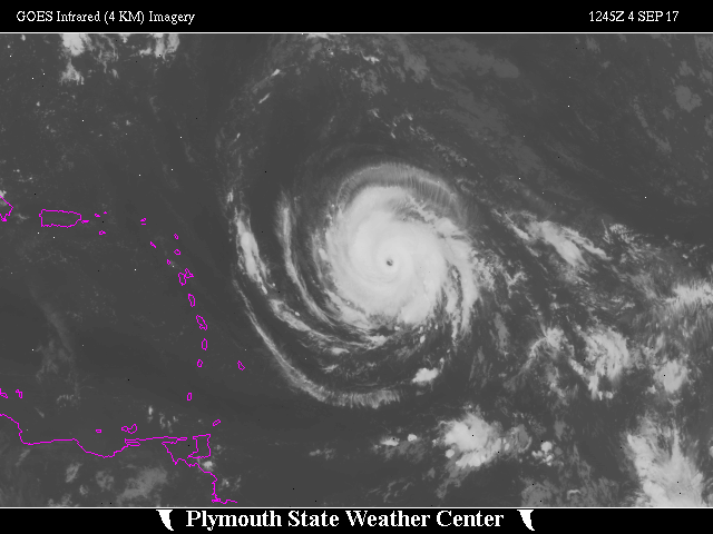
While thoughts and prayers are with our Texas FRiends and neighbors, we are at the peak of the Atlantic Tropical Storm season. Hurricane Irma continues its trek from Cape Verde across the pond and toward the Hebert Box (see below). People with interests in the Southeastern U.S. and Gulf of Mexico should be alert to the forecast path updates for this powerful storm. It is important to note that the average NHC track errors are about 175 and 225 statute miles at days 4 and 5, respectively.

Hurricane Irma originally had a small wind field. In the past 24 hours, however, the wind field has expanded with hurriance force winds up to 40 miles from the center, and tropical storm force winds up to 140 miles from the storm center.

FL Governor Rick Scott reminds Floridians: Families should take time today to make sure you have a disaster plan and fully-stocked Disaster Supply Kit. Florida residents from West Palm Beach to Tampa Bay are heeding the alert. Store shelves are emptying of bottled water.


Mash image to find lots of satellite imagery links

Public Advisories
NHC Discussions
NOAA Local Weather Statements/Radar San Juan, Puerto Rico
NHC Local Weather Statements/Radar Miami, FL
NHC Local Weather Statements/Radar Key West, FL
Buoy Data Caribbean
Buoy Data SE US & GOM


Hebert Box - Mash Pic for Tutorial
Credit: By J Cricket - Modification of map from Wiki


TOPICS: Breaking News; Extended News; Front Page News; News/Current Events; US: Florida; US: Georgia; US: North Carolina; US: South Carolina
KEYWORDS: cat6; category6; florida; hurricane; hurricaneirma; irma; livehurricaneirma; nautinurse; prepper; preppers; puertorico; virginislands
Navigation: use the links below to view more comments.
first previous 1-20 ... 241-260261-280281-300 ... 2,081-2,085 next last
To: alancarp

Also noticing that this will be no Harvey: looks like once the ‘right turn’ happens, Irma will get on her I-95 horse and bust it to the maritimes... 2 days from Miami to Nova Scotia and beyond.


261 posted on 09/04/2017 5:58:35 PM PDT by alancarp (George Orwell was an optimist.)
[ Post Reply | Private Reply | To 255 | View Replies]

To: Alas Babylon!

Thanks bud. No matter where I am I’ll be there for your Sunday thread. It’s a can’t miss thread.


262 posted on 09/04/2017 5:59:33 PM PDT by rodguy911 (Home of the free because of the brave!MAGA!)
[ Post Reply | Private Reply | To 206 | View Replies]

To: Cats Pajamas
See this post.
263 posted on 09/04/2017 6:00:04 PM PDT by alancarp (George Orwell was an optimist.)
[ Post Reply | Private Reply | To 257 | View Replies]

To: God luvs America

Yeah I posted that you can find it on the data buoys off the Keys.


264 posted on 09/04/2017 6:00:37 PM PDT by rodguy911 (Home of the free because of the brave!MAGA!)
[ Post Reply | Private Reply | To 217 | View Replies]

To: Chgogal

East of US1/west of A1A is Evacuation Zone B in Broward County, subject to a mandatory evacuation order. You could fly down there only to be ordered to evacuate.


265 posted on 09/04/2017 6:01:13 PM PDT by ameribbean expat (Veritas Vincit)
[ Post Reply | Private Reply | To 61 | View Replies]

To: NautiNurse
Thought these were quite interesting so will post here...

The 0Z September 4, 2017, track forecast by the operational European model for Irma (red line, adjusted by CFAN using a proprietary technique that accounts for storm movement since 0Z), along with the track of the average of the 50 members of the European model ensemble (heavy black line), and the 50 track forecasts from the 0Z Monday European model ensemble forecast (grey lines). Image credit: CFAN.

The 0Z September 2, 2017, track forecast by the operational European model for Irma (red line, adjusted by CFAN using a proprietary technique that accounts for storm movement since 0Z), along with the track of the average of the 50 members of the European model ensemble (heavy black line), and the track forecasts from the “high probability cluster” (grey lines)—the four European model ensemble members that have performed best with Irma thus far. Image credit: CFAN.


266 posted on 09/04/2017 6:01:56 PM PDT by caww
[ Post Reply | Private Reply | To 247 | View Replies]

To: Cats Pajamas
winds 140mph, 943mb, moving W at 13mph.

p.s. All of the graphics and and all of links (including the advisories) at the top of the thread are current with each new update.

267 posted on 09/04/2017 6:02:12 PM PDT by NautiNurse (Tear down the Mexican Carrier plant and use the materials to build the wall)
[ Post Reply | Private Reply | To 257 | View Replies]

To: caww

268 posted on 09/04/2017 6:03:10 PM PDT by caww
[ Post Reply | Private Reply | To 266 | View Replies]

To: NautiNurse; Bender2
The guy that always seems to be right (as he was with Harvey) most often is Joe Bastardi. Still early but his most likely track has me directly in the path at cat 1 at the point where the Susquehanna empties into the Chesapeake Bay in Maryland.

If that's the case will be similar to Floyd in 1999 when I was without power for a couple of weeks but that caused me to buy a back up gnerator so I should be good for awhile:


269 posted on 09/04/2017 6:03:35 PM PDT by big'ol_freeper (Liberty, when it begins to take root, is a plant of rapid growth. - George Washington)
[ Post Reply | Private Reply | To 1 | View Replies]

To: NautiNurse
And here's from Noaa


270 posted on 09/04/2017 6:05:30 PM PDT by caww
[ Post Reply | Private Reply | To 267 | View Replies]

To: big'ol_freeper

Trust you’re all prepped for this......


271 posted on 09/04/2017 6:06:30 PM PDT by caww
[ Post Reply | Private Reply | To 269 | View Replies]

To: big'ol_freeper
Joe was waxing on twitter about a Donna track... that's more-or-less his center line on his hand-drawn chart (that you included):

Here's Donna...


272 posted on 09/04/2017 6:06:38 PM PDT by alancarp (George Orwell was an optimist.)
[ Post Reply | Private Reply | To 269 | View Replies]

To: metmom

Was just thinking it could take out that sonar stuff.

I just wonder if they’ve used it on their own people and under what situation they’ve done that.


273 posted on 09/04/2017 6:06:59 PM PDT by Black Agnes
[ Post Reply | Private Reply | To 249 | View Replies]

To: big'ol_freeper

Not trying to be difficult, but that graphic has three scribble lines. How is one supposed to guess which is the “most likely” track?


274 posted on 09/04/2017 6:07:52 PM PDT by NautiNurse (Tear down the Mexican Carrier plant and use the materials to build the wall)
[ Post Reply | Private Reply | To 269 | View Replies]

To: alancarp
Looks like Irma will be avoiding most of the weather buoys before getting to Florida (once passing Puerto Rico).
275 posted on 09/04/2017 6:08:56 PM PDT by alancarp (George Orwell was an optimist.)
[ Post Reply | Private Reply | To 272 | View Replies]

To: alancarp

Wow, that storm has some staying power.

I wish these images from Weather Underground were screen shots instead of links.

The links change as the situation changes and when we go back to look the thread over, they show what is currently happening.

There’s no record of these images as they are now.

I tired doing a screen shot of the one map I posted but could not figure out how to do it.


276 posted on 09/04/2017 6:09:35 PM PDT by metmom ( ...fixing our eyes on Jesus, the Author and Perfecter of our faith..)
[ Post Reply | Private Reply | To 272 | View Replies]

To: NautiNurse

It’s the middle of the 3 lines... the outer pair represent’s Joe’s cone. High tech and all that from him.


277 posted on 09/04/2017 6:10:03 PM PDT by alancarp (George Orwell was an optimist.)
[ Post Reply | Private Reply | To 274 | View Replies]

To: NautiNurse

I’m just gonna take my husband and move to Poland.


278 posted on 09/04/2017 6:10:13 PM PDT by Cats Pajamas
[ Post Reply | Private Reply | To 267 | View Replies]

To: alancarp
Looks like Irma will be avoiding most of the weather buoys before getting to Florida (once passing Puerto Rico).

Noticed that too. Harvey did the same thing.

Then again, most buoys don't survive a Cat4/5 storm anyway.

279 posted on 09/04/2017 6:10:59 PM PDT by NautiNurse (Tear down the Mexican Carrier plant and use the materials to build the wall)
[ Post Reply | Private Reply | To 275 | View Replies]

To: alancarp

We are supposed to get low temp Friday night of 63 degrees. That is really unseasonable cool for this time of year in Panama City.


280 posted on 09/04/2017 6:12:09 PM PDT by Cats Pajamas
[ Post Reply | Private Reply | To 263 | View Replies]


Navigation: use the links below to view more comments.
first previous 1-20 ... 241-260261-280281-300 ... 2,081-2,085 next last

Disclaimer: Opinions posted on Free Republic are those of the individual posters and do not necessarily represent the opinion of Free Republic or its management. All materials posted herein are protected by copyright law and the exemption for fair use of copyrighted works.

Free Republic
Browse · Search
News/Activism
Topics · Post Article

FreeRepublic, LLC, PO BOX 9771, FRESNO, CA 93794
FreeRepublic.com is powered by software copyright 2000-2008 John Robinson