
Posted on 09/04/2017 2:02:19 PM PDT by NautiNurse
While thoughts and prayers are with our Texas FRiends and neighbors, we are at the peak of the Atlantic Tropical Storm season. Hurricane Irma continues its trek from Cape Verde across the pond and toward the Hebert Box (see below). People with interests in the Southeastern U.S. and Gulf of Mexico should be alert to the forecast path updates for this powerful storm. It is important to note that the average NHC track errors are about 175 and 225 statute miles at days 4 and 5, respectively.
Hurricane Irma originally had a small wind field. In the past 24 hours, however, the wind field has expanded with hurriance force winds up to 40 miles from the center, and tropical storm force winds up to 140 miles from the storm center.
FL Governor Rick Scott reminds Floridians: Families should take time today to make sure you have a disaster plan and fully-stocked Disaster Supply Kit. Florida residents from West Palm Beach to Tampa Bay are heeding the alert. Store shelves are emptying of bottled water.


Mash image to find lots of satellite imagery links
Public Advisories
NHC Discussions
NOAA Local Weather Statements/Radar San Juan, Puerto Rico
NHC Local Weather Statements/Radar Miami, FL
NHC Local Weather Statements/Radar Key West, FL
Buoy Data Caribbean
Buoy Data SE US & GOM

Hebert Box - Mash Pic for Tutorial
Credit: By J Cricket - Modification of map from Wiki
UPDATE:
CURRENT TRACK or a hair west= DOOM
1) might as well nuke Miami beach and get it over with..
2) much of downtown Miami will be under water from surge up the Miami River
3)the entire high population SE coast of FL will get the front eye wall
4)it will move onshore and weaken some..but its HUGE size by then will keep the surge going ..Katrina weakened to a CAT 3 at landfall but had the record Surge in MS...storms take a while for surge to decline off the max..the shape of the SC/GA coast line will funnel the water..Much of charleston will be hit with the surge on the right side and will be under water
PRAY please
recon just found the eye warming even more to 23C
Thank you Caww. I listened to McMaster’s press conference. It is still not clear what part of SC might be hit,if at all. I was reassured that there is a disaster plan in place. I sent this statement to our neighbor FB page. One person said “we never get hurricanes here in the upstate”. Yay, like Houston will never flood?
McMaster will issue an evacuation order no later than Friday.
I'm sorry to hear that, rodguy. But you and your family are out of harm's way, right?
I saw a recent report that the hurricane hunter planes are finding lower pressures.
My sister just left here (Jaackonville NC) to drive down to Pt St Lucie to get her daughter and 3 kids out and bring them back here.Please keep them in your prayers.
It would be unusual for a hurricane to remain hurricane force as far inland as Greenville but it certainly can happen, and even the tropical storm remains would cause plenty of problems enough, flooding of low lying areas primarily but some moderate wind damage isn’t out of the question. It’s a far better place to be than the immediate coastline when a hurricane comes ashore, don’t get me wrong, but it’s not going to be a total safe haven from all effects unless the track of the storm goes elsewhere, away from Greenville.
They report a “stadium effect”.
—
Hurricane hunters fly into the eerily calm eye of Irma (video at link)
http://www.sfgate.com/weather/article/irma-eye-hurricane-flight-noaa-storm-florida-12177525.php
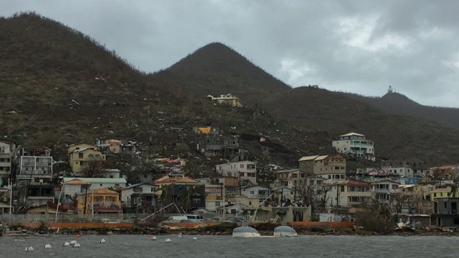
Fierce rains and 185-mph winds pelted the Virgin Islands and Puerto Rico on Wednesday afternoon as Hurricane Irma continued pushing northwest on its relentless path across the Atlantic Ocean.
While the Category 5 storm writhed below, a crew with the National Oceanic and Atmospheric Administration (NOAA) took to the air on Tuesday to survey the hurricane from within.
Calm prevailed as the crew reached the inner circle of the storm. Inside the eye, the immense pressure forces the cloud wall to curve upwards in a phenomenon known as the “stadium effect.”
Yeah, it went down while I was watching during the wee hours of the morning. Now it’s just showing the last 4 hours before it went down. It looks fairly calm at the beginning but by the end, yeowy!
It’s heart-wrenching to see that video clip of destruction. Worse, we’re going to see many more such videos by the time Irma is gone.
I can’t even imagine how one lives through a CAT 5.
Well it *hopefully* will be down to a cat 3/4 by the time it hits Florida.
Amazing. But not for $100M would I do that!
LOL yes it does! Saw his work when I was in 7th grade.
Go east, Irma, go east east east.
We’ll see but it doesn’t look good for FLA right now.
They’re should be prepared for this considering, they’re south Florida.
That Puerto Rico live cam looks like the Condado section of San Juan.
Miami mayor holding off on evacuation orders. Either stupid, or worried it will get in the way of the Keys evacuation.
Sometimes you float out your second story window clinging to a mattress and go sailing across the sound into the top of a tree. Not a place to be, a Category 5, unless you’re in a fortified structure designed to withstand it that will not flood.
Disclaimer: Opinions posted on Free Republic are those of the individual posters and do not necessarily represent the opinion of Free Republic or its management. All materials posted herein are protected by copyright law and the exemption for fair use of copyrighted works.
