Skip to comments.
Italian archaeologists find lost Roman city of Altinum near Venice
The Times ^
| 7/31/2009
| Hannah Devlin
Posted on 07/30/2009 8:37:00 PM PDT by bruinbirdman
The bustling harbour of Altinum near Venice was one of the richest cities of the Roman empire. But terrified by the impending invasion of the fearsome Germanic Emperor Attila the Hun, its inhabitants cut their losses and fled in AD452, leaving behind a ghost town of theatres, temples and basilicas.
Altinum was never reoccupied and gradually sunk into the ground. The city lived on in Venetian folk tales and historical artefacts but its exact position, size and wealth gradually faded into obscurity.
Now, using aerial photography of the region, Italian archaeologists have not only located the city, but have produced a detailed map revealing its remarkably intact infrastructure and showing it to be slightly larger than Pompeii.
The abandonment of the city and its subsequent preservation makes it an archaeological time capsule, a unique find in Roman heritage. “It’s extremely unusual for a town to go out of use like this and that is what makes it absolutely invaluable for achaeologists. It gives a full profile of what the town looked like without the imposition of modern infrastructure,” said Dr Neil Christie, a specialist in the Roman empire at the University of Leicester.
The team behind the study located the ancient city by studying hundreds of aerial photographs of the region, mostly taken by private companies for cartography purposes.
In July 2007, during a particularly dry summer, crops were suffering from drought and were highly sensitive to the subsurface presence of stones, bricks or compacted soil. On the image taken by the mapping company Telespazio, the lighter crops indicated stonework, while the darker patches revealed depressed features such as pits and canals.
The team, reconstructing the town using the aerial images and knowledge of Roman architecture, was able to identify temples, theatres, a basilica, the marketplace and city walls as
(Excerpt) Read more at timesonline.co.uk ...
TOPICS: Crime/Corruption; Culture/Society; Government; News/Current Events
KEYWORDS: altinum; attilathehun; godsgravesglyphs; lidar; romanempire; venice
Navigation: use the links below to view more comments.
first 1-20, 21-31 next last
To: bruinbirdman
But terrified by the impending invasion of the fearsome Germanic Emperor Attila the Hun
I can't take the rest of the article seriously now.
2
posted on
07/30/2009 8:42:17 PM PDT
by
Rodebrecht
(If everybody just left everybody else alone, everybody would be a lot happier.)
To: Rodebrecht
3
posted on
07/30/2009 8:53:55 PM PDT
by
LifePath
To: LifePath
Attila the Hun was Germanic? I don't think so.
4
posted on
07/30/2009 8:58:27 PM PDT
by
Rodebrecht
(If everybody just left everybody else alone, everybody would be a lot happier.)
To: bruinbirdman
El Pais has some super pictures of this:
http://www.elpais.com/articulo/sociedad/ciudad/romana/precursora/Venecia/emerge/camaras/infrarrojas/elpepusoc/20090730elpepusoc_11/Tes
5
posted on
07/30/2009 9:03:57 PM PDT
by
La Lydia
( Enoch Powell was right.)
To: bruinbirdman
Thanks for posting, very interesting find.
6
posted on
07/30/2009 9:05:12 PM PDT
by
SaxxonWoods
(Charter Member, 58 Million Club)
To: Rodebrecht
His empire included the area of historical Germany.
7
posted on
07/30/2009 9:06:26 PM PDT
by
LifePath
To: SunkenCiv; blam; Coyoteman
8
posted on
07/30/2009 9:09:26 PM PDT
by
TXnMA
("Allah": Satan's current alias...!!)
To: La Lydia; bruinbirdman; SunkenCiv; blam; Coyoteman

Color IR aerial -- probably with shadow-convolution filtering.
About the only thing better for showing occupation patterns might be
a composite of color IR and LIDAR -- or remote GPR...
Thanks for the post, bruinbirdman -- and for the link, La Lydia...
9
posted on
07/30/2009 9:21:53 PM PDT
by
TXnMA
("Allah": Satan's current alias...!!)
To: Rodebrecht
Germania (a region) was contained within the Hunnic Empire. Attila was probably born near what is now Hungary (Get it? Hun... Hungary?).
10
posted on
07/30/2009 9:29:19 PM PDT
by
stormer
To: All
How is it possible for earth to change mans actions? I thought it was only us that could cause damage to the planet through car use and such?
I don’t even think air conditioning was around to blame..This is amazing.
To: TXnMA
I’ve had some exposure to spacial analysis using remote sensing data for resource management purposes, and I’ve got to say, if I were a younger man, that’s the technology I’d be jumping in to. Incredible.
12
posted on
07/30/2009 9:33:02 PM PDT
by
stormer
To: TXnMA
From everything I've read, they haven't dug here.
What, they leave it as is to test their instruments?
yitbos
13
posted on
07/30/2009 9:40:03 PM PDT
by
bruinbirdman
("Those who control language control minds.")
To: bruinbirdman
To rephrase a line from the movie “Red October” and address it now to the Italian Ambassador, “You’ve lost a what? A city?” “How did that happen?”
To: stormer
I know where Hungary got its name. But the Huns weren’t from there; they settled there. They were originally from Asia.
15
posted on
07/30/2009 10:10:46 PM PDT
by
Rodebrecht
(If everybody just left everybody else alone, everybody would be a lot happier.)
To: Rodebrecht
Thank you for your sanity. I saw this article and was about to post the same thing you did, when I saw that you had already defended Germania. It is scary how fragile knowledge of the past is.
16
posted on
07/31/2009 12:08:33 AM PDT
by
Defiant
(Reaganland vs. Obamastan: Let's go our separate ways.)
To: bruinbirdman; StayAt HomeMother; Ernest_at_the_Beach; 1ofmanyfree; 21twelve; 24Karet; ...
17
posted on
07/31/2009 6:26:08 PM PDT
by
SunkenCiv
(https://secure.freerepublic.com/donate/__Since Jan 3, 2004__Profile updated Monday, January 12, 2009)
To: TXnMA
18
posted on
07/31/2009 6:37:22 PM PDT
by
SunkenCiv
(https://secure.freerepublic.com/donate/__Since Jan 3, 2004__Profile updated Monday, January 12, 2009)
To: stormer; SunkenCiv; blam; bruinbirdman; Coyoteman
As a member of the Texas Historical Commission's Archeological Stewards Network, my main activities are focused on the location and mapping of early roads, trails, and "Traces". That means that most of my work is concentrated on overhead imagery analysis, cartography and GIS.
A small group of us "Rut Nuts" were just scheming as to how we could get access to a small, LIDAR-equipped 'copter for mapping out things like Trammel's Trace and the "roads" and campsites left by several Spanish military expeditions across Texas...
LIDAR, of course, is "Laser RADAR", which can achieve at least two inch vertical resolution -- and can effectively "see through" an overhead vegetation canopy...
That Altinium image sure looks like LIDAR to me...
~~~~~~~~~
Yep -- I've "been into" spatial analysis for archeology (official TX spelling, BTW) for many years.
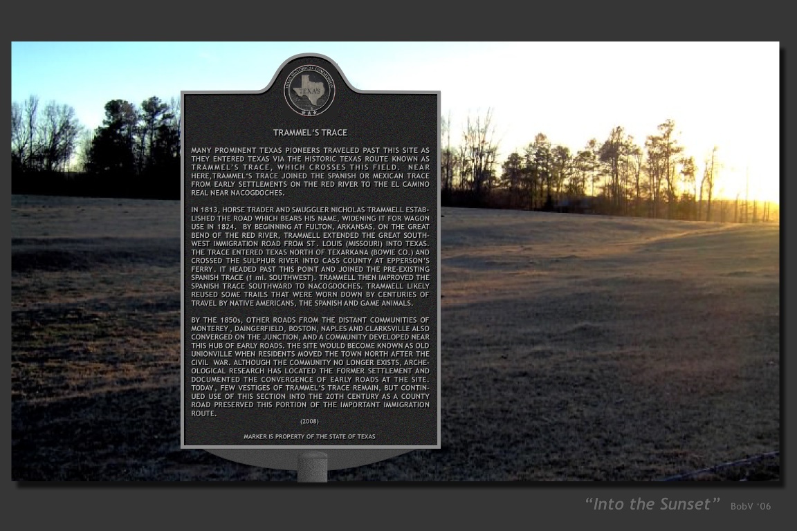
Here's one of my current projects -- a new State Historical Marker at the only (known) site where Trammel's Trace is visible from a Texas state Highway. (The "marker" is virtual -- CGI that exists only in my computer.)
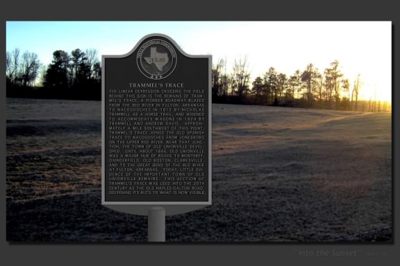
...and HERE IS a high-res image (with readable inscription) of that scene with the final "virtual" version of the marker -- which is at the foundry, being cast right now...
19
posted on
07/31/2009 9:35:13 PM PDT
by
TXnMA
("Allah": Satan's current alias...!!)
To: La Lydia
Meant to include you in the “pingees” to # 19...
20
posted on
07/31/2009 9:39:36 PM PDT
by
TXnMA
("Allah": Satan's current alias...!!)
Navigation: use the links below to view more comments.
first 1-20, 21-31 next last
Disclaimer:
Opinions posted on Free Republic are those of the individual
posters and do not necessarily represent the opinion of Free Republic or its
management. All materials posted herein are protected by copyright law and the
exemption for fair use of copyrighted works.
FreeRepublic.com is powered by software copyright 2000-2008 John Robinson