
Posted on 09/12/2008 11:29:13 PM PDT by NautiNurse
The eyewall of Hurricane Ike crossed Galveston Island in the early hours of Saturday morning. Reports indicate as many as 20,000 residents of Galveston Island chose not to evacuate as storm surge engulfed the island. The Freeport Chief of Police reported as many as 2000 residents did not evacuate as flood waters swamped coastal communities. There are widespread reports of power outages and coastal flooding throughout the Texas/Louisiana region. The U.S. Coast Guard received hundreds of calls Friday afternoon to rescue people stranded by flood waters along the barrier islands and Galveston Bay communities.
Multiple fires broke out in the Greater Houston area fueled by strong winds. Fire fighting efforts were hampered by flood waters. Brennan's Restaurant, a landmark in Houston, burned to the ground. A 584-foot freighter crippled in the Gulf of Mexico and its crew of 22 survived the storm after The U.S. Coast Guard was forced to abort rescue efforts Friday afternoon due to foul weather
Gulf Coast wholesale gasoline prices jumped to nearly $5 a gallon over fears that water and wind damage could keep the facilities closed for days or longer. Oil companies had shut down 97.5 percent of production in the Gulf of Mexico by Friday morning and were battening down refineries and petrochemical plants in an area that accounts for one-fifth of U.S. refining capacity.
Exxon Mobil reported evacuating workers from its Gulf Coast offshore platforms and onshore facilities in the anticipated path of Ike, shutting down daily production of about 36,000 barrels of oil and 270 million cubic feet of gas..
Public Advisory Updated every 3 hours
Discussion Updated every 6 hours
Buoy data: Western Gulf of Mexico
Houston/Galveston Long Range Radar
Corpus Christi Long Range Radar
Brownsville Long Range Radar
Lake Charles Long Range Radar
|
||||||||||||||||||||||||||||||||||||||||||||||||||||||||
Additional Resources:
Navy Tropical Cyclone
Storm Pulse Very cool site
KHOU Houston
ABC 13 News Houston
FOX News Houston
KPLC Lake Charles
KFDM 6 Beaumont/Port Arthur
KKBMT 12 Beaumont
KRIS-TV Corpus Christi
KZTV Corpus Christi
Brazoria County Emergency Management
Galveston County Emergency Management
Chambers Country Emergency Management
Liberty County Emergency Management
| Category | Wind Speed | Barometric Pressure | Storm Surge | Damage Potential |
|---|---|---|---|---|
| Tropical Depression |
< 39 mph < 34 kts |
Minimal | ||
| Tropical Storm |
39 - 73 mph 34 - 63 kts |
Minimal | ||
| Hurricane 1 (Weak) |
74 - 95 mph 64 - 82 kts |
28.94" or more 980.02 mb or more |
4.0' - 5.0' 1.2 m - 1.5 m |
Minimal damage to vegetation |
| Hurricane 2 (Moderate) |
96 - 110 mph 83 - 95 kts |
28.50" - 28.93" 965.12 mb - 979.68 mb |
6.0' - 8.0' 1.8 m - 2.4 m |
Moderate damage to houses |
| Hurricane 3 (Strong) |
111 - 130 mph 96 - 112 kts |
27.91" - 28.49" 945.14 mb - 964.78 mb |
9.0' - 12.0' 2.7 m - 3.7 m |
Extensive damage to small buildings |
| Hurricane 4 (Very strong) |
131 - 155 mph 113 - 135 kts |
27.17" - 27.90" 920.08 mb - 944.80 mb |
13.0' - 18.0' 3.9 m - 5.5 m |
Extreme structural damage |
| Hurricane 5 (Devastating) |
Greater than 155 mph Greater than 135 kts |
Less than 27.17" Less than 920.08 mb |
Greater than 18.0' Greater than 5.5m |
Catastrophic building failures possible |
|
|
Previous Threads:
Hurricane Ike Live Thread III
Hurricane Ike Live Thread II
Hurricane Ike Live Thread I
TS Hanna, Hurricane Ike & TS Josephine [Other than that, the tropics are calm]
Tropical Storms Hanna, Ike and Josephine, TD Gustav (Other than that, the tropics are calm)
You can use your FEMA card at the track, in the slot machines at the casino, at the Guicci Store, at the gentlemen’s clubs, at the plastic surgeon, at the liquor store and at Neiman’s. Kroger and Home Depot do not accept them. :-) Enjoy!!!
LOl!
Where are they?
The problem with Crystal Beach/Gilchrist/High Island is that the ferry was shut down Friday and the only way in/out was the coastal highway. It’s a very narrow two lane road that is often washed away in hurricanes. From Port Bolivar to High Island (where the road turns north to go to Winnie) is about 25-30 miles. Between Gilchrist and High Island the highway is very close to the beach. If the water was already coming up, that was the only escape route and the road may have already been impassable. There would be no way to get out from the area because the surge came in a lot earlier than the hurricane.
With currents that strong, I don’t think many can wade through 30 miles.
Those people are private people and the media is not to be trusted :-)
I agree...I was just posting what someone else placed on a forum...don’t know if its fact or fiction;)
Makes me so mad. The NG nor FEMA should be givin out anything within 20 miles of a store carrying it. Did those look like Deer Park folks or typical moochers from other areas like Pasadena?
While it may turn out to be true, I don’t buy it one little bit. You’d be surprised some of the cuckoos that post BS to stir everyone up. Sickos. How does someone find 4000 bodies? It doesn’t add up. Our friends that live on the island are returning from SATX tomorrow. Their neighbors are home and said their place is okay with just some superficial damage.
Great info thanks!
You wouldn’t think someone trying to get out would be counting bodies. I’m not saying she didn’t see any but I’m taking the 4K as doubtful.
I’m thinking a little of everything, there were several stations all over town. Most were new - 1 year old vehicles lined up down Center waiting. We just laughed and wondered how much gas they used sitting their idling for well over an hour (maybe two more more hours) to get a free bag of ice and a free gallon of water. Sometimes people are so stupid when they hear “FREE”.
Glad to hear you got stocked up at the store and are making the last leg of your journey home. Please let me know how you find your home. I’ll be logging off soon as I have other things I need to tend to and this gets too addictive. I also have an early doctor’s appt but will check in around 10:00 or so. I’ll say a prayer for you tonight and hope you have even less damage than I did.
It’s too far fetched. If she said she saw 200, well, maybe but 4000? Nope, I don’t buy it. That would be just in the area she was in too, not the entire island and the Bolivar to High Island area. I doubt that the Bolivar to High Island area has much more than that in population even in the summer months. Even when 3000+ people died in the WTC, did any one person see that many?
If one accepts the posit that 85% of the people who didn’t evacuate had cell phones, telecoms could count the number of accounts with no recent activity or GPS signal - underwater or otherwise not working.
I don't think it's a Photoshop hoax, GovernmentShrinker. If you take a look at this photo that jeffers posted (of a satellite image of what's left of the island) in #2710 you will see that house. Click on that image to zoom it way up; the house is near the left of the image, on the gulf-side, by the wide area of erosion (landmark for that "cut" is the light streak going down the water to the bottom of the image). It is the house. In-freaking-credible!
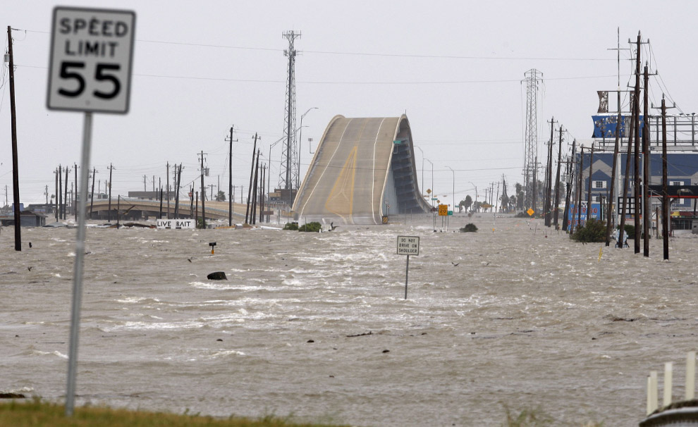
Can anyone explain to me why they put this hump in the highway like this? (I have never been to the area so from this picture view it really looks odd)
http://cache.boston.com/universal/site_graphics/blogs/bigpicture/ike_09_15/ike7.jpg
Please stop acting like an argumentative and ignorant boob. If you had taken the initiative to read the comment in the prior post, you would have understood that magic word—the context. Enough already.
seeker41 wrote:
My friend got off the island with pictures today and they are sick. Bodies everywhere! The
numbers on the island are 4000+. Where is the national media....where is the outcry. By this time
in Katrina there were telethons...and here nothing. The pictures have been sent to Nytimes, cnn,
etc and nobody has posted about them. Mark my words tomorrow there will be headlines, and if
not in the papers than in the blogs because this is a higher death count than Katrina and 9/11
combined. This is sick...and it is true. On the island they are telling them not to talk so as to give
them time to notfy the families..but a national spotlight is needed. This is bigger then the
DOWJones and wall street. This is huge.
This was just posted here http://www.khou.com/forums/viewtopic.php?t=27523&start=30
Have no idea if true
************
Take that with a MAJOR grain of salt.
At the same time, don’t ignore it either.
Without confirmation, it is either a FALSE RUMOR, or else a TRUE FACT NOT CONFIRMED.
Until we know, it’s worth about as much as the stories of post Katrina cannabalism.
We don’t need any more of that.
Perusing aerial imagery grids of Galveston and Bolivar Peninsula, I’d say Galveston, even the west end, got off easy. Yeah, there’s damage, but it’s more like one home in ten missing big pieces, others apparantly intact, overall, with most of those close to the beach.
On Bolivar, it’s a LOT worse. I’d be a LOT more inclined to buy “thousands dead’ on Bolivar than Galveston, based on post storm imagery, which I consider to be hard data.
Disclaimer: Opinions posted on Free Republic are those of the individual posters and do not necessarily represent the opinion of Free Republic or its management. All materials posted herein are protected by copyright law and the exemption for fair use of copyrighted works.