Skip to comments.
Wildfire News Thread, 7/13: Sawtooth Fire News and More
NICC, NIFC, WFAS ^
| 7/13/06
| Various
Posted on 07/13/2006 5:30:54 AM PDT by Knitting A Conundrum


Haines Index Map - Higher Haines means fire growth tends to be stronger:

Fuel Dryness: Tells you how likely things are to burn if a fire gets started:


INCIDENT MANAGEMENT SITUATION REPORT
THURSDAY, JULY 13, 2006 – 0530 MDT
NATIONAL PREPAREDNESS LEVEL 3
CURRENT SITUATION:
Initial attack activity was light nationally with 167 new fires reported. Nine new large fires (*) were reported, three in the Eastern Great Basin Area, two each in the Northern Rockies and Western Great Basin Areas and one each in the Northern California and Northwest Areas. Six large fires were contained, two in the Eastern Great Basin Area and one each in the Southern California, Western Great Basin, Northern California and Southern Areas. Very high to extreme fire indices were reported in Oregon, Arizona, Alaska, California, Minnesota, Montana, Nebraska, Nevada, New Mexico, North Dakota, South Dakota, Utah and Wyoming.
A Type 1 Incident Management Team (Opliger) is assigned to the 21,651 acre Wutlus Lake fire 37 miles west of Quesnel, British Columbia, Canada. No new information was reported.
SOUTHERN CALIFORNIA AREA INCIDENTS/LARGE FIRES:
SAWTOOTH COMPLEX, San Bernardino Unit, California Department of Forestry and Fire Protection (CDF). A Unified Command has been established between a CDF Type 1 Incident Command Team (Henson) and the US Forest Service. This complex, comprised of the Sawtooth, Waters, and Ridge fires, is two miles east of Yucca Valley, CA, in chaparral. Numerous residences remain threatened. Voluntary evacuations for Morongo Valley and portions of Yucca Valley have been implemented. Road closures including Highway 247, Wamego, Pipes Canyon, and Pioneertown are in effect. Weather and steep, inaccessible terrain are impeding containment efforts. Extreme fire behavior with significant upslope runs was reported.
MILLARD COMPLEX, San Bernardino National Forest. A Unified Command has been established between a Type 2 Incident Management Team (Walker), a CDF Type 1 Incident Command Team (Hutchinson) and the Riverside County Fire Department. This complex, comprised of four fires, is seven miles north of Cabazon, CA in chaparral and conifer. Numerous residences and cultural resources are threatened. Increased fire activity is hampering containment. Extreme fire behavior with rapid spread was observed.
ARCO, Kern County Fire Department. This fire is five miles north of Lebec, CA in chaparral. No further information was received. This will be the last report unless new information is received.
NORTHERN ROCKIES AREA INCIDENTS/LARGE FIRES:
BUNDY RAILROAD, Billings District, Bureau of Land Management. A Type 2 Incident Management Team (McNitt) has been ordered. This fire is eight miles northeast of Warden, MT in timber, grass, and sage. High winds from passing thunderstorms contributed to extreme fire behavior.
SAUNDERS, Southern Land Office, Montana Department of Natural Resources and Conservation. A Type 2 Incident Management Team (Heintz) is assigned. This fire is four miles west of Columbus, MT in grass and timber. Numerous residences remain threatened, and evacuations remain in effect. Brumfield and Countryman Creek Roads remain closed. Minimal fire behavior was reported.
PINE RIDGE COMPLEX, Southern Land Office, Montana Department of Natural Resources and Conservation. This complex, comprised of five fires, is south of Pompeys Pillar, MT in sagebrush and agricultural fields. One residence and a pipeline are threatened. Extreme fire behavior was observed.
NORTHERN CALIFORNIA AREA INCIDENTS/LARGE FIRES:
CANYON, Santa Clara Unit, California Department of Forestry and Fire Protection (CDF). A CDF Type 1 Incident Command Team (Paul) is assigned. This fire is 11 miles west of Patterson, CA in chaparral. Several residences and ranches remain threatened and voluntary evacuations are in effect. Del Puerto Canyon Road remains closed to civilian traffic. Difficult access, steep terrain, and weather continue to impede containment. Very active fire behavior with significant runs, spotting, and torching was reported.
YOLLA BOLLY COMPLEX, Mendocino National Forest. A transfer of command from a Fire Use Management Team (Perkins) back to the local unit has occurred. This lightning-caused Wildland Fire Use (WFU) incident is being managed to accomplish resource objectives. This incident is 35 miles west of Red Bluff, CA in timber. Continued surface fire and torching were observed. This will be the last narrative report unless significant activity occurs.
EASTERN GREAT BASIN AREA INCIDENTS/LARGE FIRES:
SAGE VALLEY, Richfield Field Office, Bureau of Land Management. This fire is 10 miles north of Mills, UT in pinyon pine, juniper, grass and sagebrush. A residence, outbuildings and a gas line are threatened. Major fire runs and spotting were reported.
BABOON 2, Cedar City District, Bureau of Land Management. This fire is 10 miles south of Minerville, UT in cheatgrass, sagebrush, pinyon pine and juniper. State Route 130 is closed. Good access is aiding suppression efforts. Active fire behavior included running, crowning and spotting.
LAKE RIDGE, Northwest Area Office Idaho Department of Lands. This fire is eight miles east of Bear Lake, UT in grass, sagebrush and brush. Minimal fire activity was reported.
WEST KANOSH, Fish Lake National Forest. This fire is six miles southwest of Kanosh, UT in brush and hardwood slash. Crowning, running and spotting were reported.
WESTERN GREAT BASIN AREA INCIDENTS/LARGE FIRES:
STORM CLOUD, Carson City Field Office, Bureau of Land Management. This fire is 35 miles northwest of Austin, NV in brush, grass, pinyon pine and juniper. Good overnight humidity recovery slowed the fire progress. Moderate fire behavior with occasional torching was observed.
BALLY, Ely District, Bureau of Land Management. This fire is seven miles northeast of Barley, NV in brush, slash, and Pinyon Juniper. High winds and low relative humidity are hampering containment efforts. Extreme fire behavior, with crowning runs and spotting was observed.
NORTHWEST AREA INCIDENTS/LARGE FIRES:
SPUR PEAK, Okanogan/Wenatchee National Forest. A Washington Type 2 Interagency Incident Management Team (Jennings) is assigned. A transfer of command back to the local unit will occur tomorrow. This fire is 13 miles northeast of Winthrop, WA in spruce and lodgepole pine. Forest road and trail closures remain in effect. A campground remains closed. Minimal fire activity was reported.
WHITE KING, Klamath-Lake District, Oregon Department of Forestry. This fire is nine miles northwest of Lakeview, OR in timber. Smoldering, creeping, and some torching were reported.
TIN PAN, Okanogan-Wenatchee National Forest. A Fire Use Management Team (Furlong) is assigned. This lightning-caused Wildland Fire Use (WFU) incident is being managed to accomplish resource objectives. This fire is seven miles west of Lucerne, WA in timber. The fire received some precipitation. Limited fire spread, smoldering, and creeping were reported.
SOUTHERN AREA INCIDENTS/LARGE FIRES:
LINDSEY BAY, National Forests of Florida. This fire is five miles southeast of Wilma, FL in southern rough. Structure protection is in place and an evacuation plan for an adjacent community has been prepared. Some light precipitation fell over the fire area.
OUTLOOK:
Red Flag Warnings: In southwest and central Wyoming for gusty southwest winds and low relative humidity.
Fire Weather Watches: In the plains of central Montana and northeast Montana for low relative humidities and gusty winds.
Weather Discussion: A low pressure trough will move across the northern Plains today with gusty winds over portions of the Great Basin, Northern Rockies, and Rocky Mountain Areas. Thunderstorms will develop over portions of Arizona, New Mexico, and the Plains.
Full NICC Report:
http://www.nifc.gov/nicc/sitreprt.rtf
TOPICS: News/Current Events; US: Alaska; US: Arizona; US: California; US: Colorado; US: Idaho; US: Montana; US: Nevada; US: New Mexico; US: Oregon; US: Utah; US: Washington; US: Wyoming
KEYWORDS: californiafire; sawtooth; sawtoothfire; wildfire; wildlandfire
Navigation: use the links below to view more comments.
first 1-20, 21-40, 41-60, 61-63 next last
All firenews eyes will be on Southern California today as we see the Sawtooth complex continue to burn, possibly meeting up with the Millard complex.
Other fire hotspots today are Montana, with the Bundy Railroad fire and active fires in Utah and Nevada.
News updated as I find it and can post it.
Let me know if you want on the Wildland fire ping!
To: Knitting A Conundrum
2
posted on
07/13/2006 5:32:33 AM PDT
by
Knitting A Conundrum
(Act Justly, Love Mercy, and Walk Humbly With God Micah 6:8)
To: Knitting A Conundrum
YUCCA VALLEY, Calif. (AP) - At least 42 homes have now been lost to a wildfire east of Los Angeles that's grown to 37,000 acres.
The tally of destroyed houses rose after authorities were able to make a detailed count. Another 55 buildings and 91 vehicles have also burned.
Some 800 to 1,000 people remain evacuated from a-half dozen areas, including Pioneertown, which has been used as a backdrop for Western movies dating back to the 1940's.
The wildfire is moving southwest on winds of up to 40 miles-per-hour. The fear is that it could move into San Bernardino National Forest, threatening the resort community of Big Bear Lake.
Some 25,000 firefighters are on the lines. Containment remains at 16 percent. Temperatures have pushed as high as 108 degrees.
http://www.fox6.com/news/national/story.aspx?content_id=304B103A-953C-4A3D-8001-303FA572B3EB&rss=national
3
posted on
07/13/2006 5:33:46 AM PDT
by
Knitting A Conundrum
(Act Justly, Love Mercy, and Walk Humbly With God Micah 6:8)
To: Knitting A Conundrum
It's not just California, either:
Billings fire officials are keeping a close watch for any flare ups after containing a grass fire that burned dangerously close to homes in The Heights.
The fire was reported before 7:00 p-m Wednesday near Harvest Church, by the High Sierra subdivision.
Emergency crews at Billings Logan Airport were the first to spot the fire.
Firefighters from the Billings Fire Department, Shepherd, Lockwood and the Department of Natural Resources and Conservation all pitched in to beat back flames that came within ten feet of some homes.
Witnesses say the smoke across the Billings' Heights was so thick that at times visibility was down to just a few feet.
The homes at greatest risk of burning were the houses right behind Skyview High School.
The fire scorched as many as 400 acres of grassland in The Heights.
http://www.kaj18.com/Global/story.asp?S=5144075
4
posted on
07/13/2006 5:35:25 AM PDT
by
Knitting A Conundrum
(Act Justly, Love Mercy, and Walk Humbly With God Micah 6:8)
To: Knitting A Conundrum
PATTERSON, Calif. Strong winds and rugged terrain are making for tough going as firefighters battle a wildfire near the Stanislaus and Santa Clara County lines.
At last check, the fire had consumed nearly 17-thousand acres and was heading southwest over ranch land toward Henry Coe State Park.
A spokesman for the state Department of Forestry and Fire Protection says eight buildings -- mostly hunting cabins and lodges -- have been destroyed.
Another 80 buildings and a winery are threatened by the blaze.
Three firefighters have been treated for minor heat-related illnesses. Some residents in the area have voluntarily evacuated.
http://www.kesq.com/Global/story.asp?S=5144893
5
posted on
07/13/2006 5:48:32 AM PDT
by
Knitting A Conundrum
(Act Justly, Love Mercy, and Walk Humbly With God Micah 6:8)
To: Knitting A Conundrum
nited Press International
More than 1,200 firefighters battled an enormous wildfire in the desert east of Los Angeles for a fifth day Thursday, but reported only 15 percent containment.
The fire has charred 37,000 acres, destroyed 42 houses, 55 other buildings and 91 vehicles around the high Mojave desert community of Yucca Valley 100 miles east of Los Angeles, authorities said.
At least eight firefighters and two civilians have suffered minor injuries, The Los Angeles Times reported. Wednesday, firefighters labored in 108-degree temperatures.
The fire, called the Sawtooth Complex fire, was started Sunday by a lightning strike.
Everything that can make a complex fire is lined up here, state fire official Karen Guillemin told the Times. You have the winds, the steep canyons and the low humidity.
Lightning strikes sparked four other fires in the nearby San Gorgonio Wilderness Wednesday, burning more than 2,000 acres, the report said.
http://www.woai.com/news/national/story.aspx?content_id=2CAA47C0-FB13-4D66-AA1A-783074077EB2
6
posted on
07/13/2006 5:49:47 AM PDT
by
Knitting A Conundrum
(Act Justly, Love Mercy, and Walk Humbly With God Micah 6:8)
To: Knitting A Conundrum
Incident: Saunders Wildland Fire
Released: 2006-07-12 18:26:00
SAUNDERS FIRE
NEWS RELEASE
(406) 254-9536
www.inciweb.org
SAUNDERS FIREFIGHTERS HELP WITH TWO NEW FIRES
Columbus, Mont., July 12, 2006, 3:45 p.m.—Firefighters from the Saunders fire near Columbus responded to two new fires in Carbon County.
One fire was reported to be on the 4C Ranch and the other near the Joliet cemetery.
The fires are under the jurisdiction of the Joliet fire department.
The Saunders fire sent a small helicopter and six engines and about 18 firefighters. The Columbus fire department sent five engines, a water tender, and nine firefighters.
http://inciweb.org/incident/news/article/277/526/
7
posted on
07/13/2006 5:50:47 AM PDT
by
Knitting A Conundrum
(Act Justly, Love Mercy, and Walk Humbly With God Micah 6:8)
To: Brad's Gramma; drungus; george76; familyop; moondoggie; Arizona Carolyn; nw_arizona_granny; ...
wildfire ping!
It's early and there's not a lot of really fresh info, but I wanted to get the thread going.
8
posted on
07/13/2006 5:53:02 AM PDT
by
Knitting A Conundrum
(Act Justly, Love Mercy, and Walk Humbly With God Micah 6:8)
To: Knitting A Conundrum
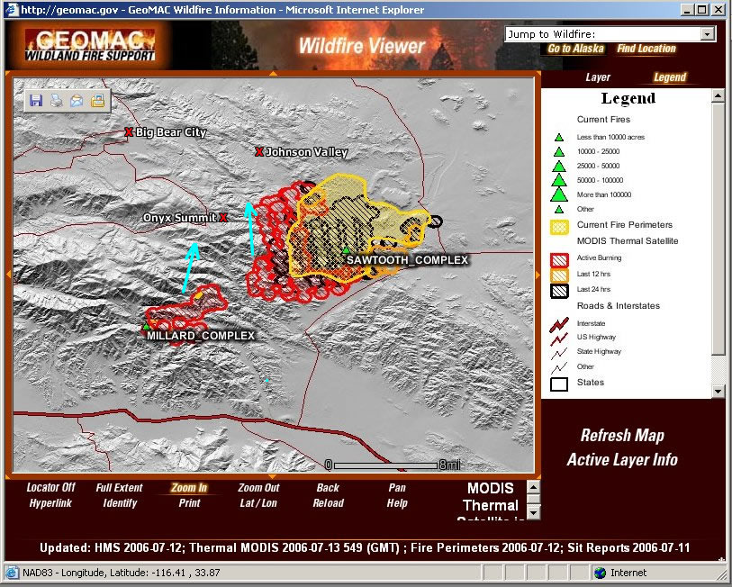
The western flank, or "Branch 2", of the Sawtooth Fire is about 3/4 of a mile east of homes in the Onyx Summit area.
CDF Fire Prevention Specialist Karen Guillemin told the Associated Press this morning that if a fire did make it into the bark beetle and drought ravaged trees, "it will be almost impossible to stop."
The Sawtooth Complex Fire is now 15% contained, according to fire officials. Most of the containment is along the north side near Old Woman Springs Road. Air Attack will resume at 6 AM with a full air assault of nearly twenty aircraft attacking the fire today.
With the western edge of the fire less than a mile from the outlying homes near Onyx Summit, Big Bear and San Gorgonio area residents are urged to start thinking about what they may need if they're asked to evacuate. So far, however, only three children's camps have been evacuated.
http://www.rimoftheworld.net/columns/rotw/fire_nears
9
posted on
07/13/2006 6:51:16 AM PDT
by
Knitting A Conundrum
(Act Justly, Love Mercy, and Walk Humbly With God Micah 6:8)
To: Knitting A Conundrum
10
posted on
07/13/2006 6:53:25 AM PDT
by
Knitting A Conundrum
(Act Justly, Love Mercy, and Walk Humbly With God Micah 6:8)
To: Knitting A Conundrum
Thanks again for keeping us informed.
My thoughts and prayers to all in the paths of these terrible wildfires.
I've been lurking lately as most of my time is being spent nursing a seriously injured pet.
To: moondoggie
oooh. Hope pet is healing...that's always a hard one.
12
posted on
07/13/2006 6:56:41 AM PDT
by
Knitting A Conundrum
(Act Justly, Love Mercy, and Walk Humbly With God Micah 6:8)
To: Knitting A Conundrum
(CBS/AP) Firefighters struggled to keep a 37,000-acre desert wildfire from spreading to the mountain resort community of Big Bear Lake, fighting against winds and blistering heat that kept fanning the flames.
It was worst combination for firefighters, reports CBS News correspondent Steve Futterman (audio): dry brush, hills that haven't burned for years, temperatures over 100, and low humidity.
The fire was moving southwest, pushed by 10 mph winds and gusts between 25 and 40 mph. About 1,000 evacuees from Pioneertown, Burns Canyon, Rimrock, Gamma Gulch, Flamingo Heights and Little Morongo Canyon had not returned to their homes, said Capt. Marc DeRosier of the California Department of Forestry.
The smoke and flames force nearly 1,000 residents to evacuate, reports CBS News correspondent Vince Gonzales. Firefighters worked hard but couldn't stop the blaze from destroying homes, vehicles, and buildings.
Air power was helping to slow the fire down, but the weather continues to heat up.
Fire officials worried if the blaze continued west toward the San Bernardino National Forest, it could grow rapidly and get dangerously close to Big Bear Lake, a community of summer lake resorts, winter skiing and about 5,500 residents. A severe bark beetle infestation has killed many trees in recent years, and would fuel the fire.
"If it starts in there it will be almost impossible to stop," said CDF spokeswoman Karen Guillemin.
The fire, ignited during the weekend by lightning, has destroyed at least 42 houses, 55 other buildings and 91 vehicles around this high desert community 100 miles east of Los Angeles, authorities said.
"Here's the front door over here. This was the living room," one homeowner told Futterman.
Historic buildings that made nearby Pioneertown famous, old western-style saloons and storefronts that once were props for movie cowboys like Gene Autry and Roy Rogers, were spared.
Temperatures hit 108 degrees Wednesday as 2,500 firefighters attacked flames devouring Joshua trees, pinon pines and brush in hills and canyons. Highs in the 100s are forecast for the Pioneertown area through the weekend, with winds 5 to 15 mph. Higher up at Big Bear Lake, temperatures in the mid-80s were forecast for Thursday.
A blanket of smoke darkened the sky over the Mojave Desert north of Yucca Valley.
In the Gamma Gulch area, dead animals littered a property where a home and barn burned. Eight firefighters and two civilians were treated for minor burns or smoke inhalation.
Residents watched nervously in Morongo Valley, where large ranch homes are surrounded by highly combustible greasewood and Joshua trees, pinon pines and brush.
Elsewhere in the West, several new wildfires in southern Montana spread quickly — one to an estimated 10,000 acres — because of windy weather.
At least one house on the Crow Indian Reservation was reported destroyed by a blaze estimated at 4,500 acres, said Jon Kohn, an information officer for the Crow Agency Bureau of Indian Affairs' Forestry division.
There also was a 3,150-acre wildfire west of Columbus, and another burning north of Pompeys Pillar that was estimated at 10,000 acres, said Mary Apple, a spokeswoman with the Bureau of Land Management.
Wildfires have burned more than 4 million acres nationwide, almost twice the 10-year average for this time of year, according to the National Interagency Fire Center.
http://www.cbsnews.com/stories/2006/07/13/national/main1798848.shtml
13
posted on
07/13/2006 7:00:31 AM PDT
by
Knitting A Conundrum
(Act Justly, Love Mercy, and Walk Humbly With God Micah 6:8)
To: Knitting A Conundrum
Sawtooth 15% Contained; However Fires May Merge
Breaking News
By RIMOFTHEWORLD.net
Thursday, July 13, 2006
A spot fire has been reported at the intersection of San Jacinto St and Laurel Dr in Morongo Valley — less than one mile from Highway 62.
Little Morongo Canyon now has a mandatory evacuation. The fire has destroyed 42 homes and 55 outbuildings — about 20 homes were in the Pioneertown area.
The Sawtooth Complex Fire is now 15% contained, according to fire officials. Most of the containment is along the north side near Old Woman Springs Road. Air Attack will resume at 6 AM with a full air assault of nearly twenty aircraft attacking the fire today.
The twin headed monster of the Millard Complex Fire and the Sawtooth Complex Fire will likely combine on Thursday creating a massive single wildfire that will stretch over twenty miles, straining resources as they cope with structure protection and rescues throughout the affected areas. The San Bernardino National Forest has assumed "Unified Incident Command" for both fires, overseeing the efforts of state, county, and local fire agencies.
http://www.rimoftheworld.net/columns/rotw/massive
14
posted on
07/13/2006 7:01:55 AM PDT
by
Knitting A Conundrum
(Act Justly, Love Mercy, and Walk Humbly With God Micah 6:8)
To: Knitting A Conundrum
Montana News:
Incident: Saunders & Shane Ridge Wildland Fires
Released: 2006-07-13 09:16:00
SAUNDERS & SHANE RIDGE FIRES
DAILY INFORMATION FACT SHEET
(406) 254-9536
www.inciweb.org
DATE: Thursday, July 13, 2006, 7 a.m.
The Saunders fire is human-caused fire four miles west & southwest of Columbus, Mont., in Stillwater County. The Shane Ridge fire stared on July 12 from lightning five miles west of Joliet in Carbon County.
INCIDENT COMMANDER (for both fires): Tom Heintz, Lead Public Information Officer: Pat McKelvey
AGENCIES: Local volunteer fire departments, Bureau of Land Management, Forest Service, Montana Department of Natural Resources and Conservation.
CURRENT RESOURCES:
PERSONNEL: 370
ENGINES: 49
BULLDOZERS: 3
HELICOPTERS: 3
CURRENT SITUATION: The Saunders fire was quiet on Wednesday. There were some isolated smokes and some open flames in the fire’s interior. Good progress was made by firefighters on further cooling and building the fire line.
The Saunders fire is now 75% contained. The fire has burned 3150 acres of grass and trees near subdivisions. A front passed through the area on Wednesday between 5:45 and 6:30 p.m. with high winds, lightning, and rain. While the rain was intense, there wasn’t much soaking moisture. Two homes, an old homesteader cabin, and an unoccupied house have been burned down by the Saunders fire. Investigators reported that the fire is human caused, and investigations continue.
Homeowners in the Countryman Creek Ranch Estates have been allowed to return on a limited basis but remain under an evacuation order. Residents of the Yellowstone Ranch Estates remain under an evacuation order. Residents needing more information should contact the Stillwater County Sheriff’s Office.
A public meeting was held in Columbus that 64 people attended.
The Shane Ridge fire has about 125 firefighters from Fromberg, Columbus, Red Lodge, Joliet, and the Saunders fire have this 847-acre fire 40% contained.
ACTIONS PLANNED: Crews and engines on both fires will keep working on control lines. At the Saunders fire mop-up will be done within 200 feet of the perimeter and next to residences.
SPECIAL MESSAGE: In fire-prone areas, it’s vital for homeowners to reduce the amount of grass, needles, and trees that are close to homes. For ideas on making your home safe, go to www.firewise.org.
Fire-truck traffic will be heavy on many narrow roads in the area. Residents should drive with extra caution.
http://inciweb.org/incident/news/article/277/527/
15
posted on
07/13/2006 7:05:46 AM PDT
by
Knitting A Conundrum
(Act Justly, Love Mercy, and Walk Humbly With God Micah 6:8)
To: Knitting A Conundrum
| Last Updated: |
July 13, 2006 7:00 am |
|
| Date/Time Started: |
July 9, 2006 8:30 am |
| Administrative Unit: |
CDF San Bernardino Unit |
| County: |
San Bernardino |
| Location: |
2 miles est of Yucca Valley |
| Acres Burned: |
40,000 |
| Containment |
20% containment |
| Structures Destroyed: |
42 residences and 55 outbuildings destroyed |
| Threatened: |
3,000+structures continue to be threatened in the fire area. |
| Evacuations: |
Mandatory evacuations for Pioneertown, Burns Canyon, Rimrock, Skyline Ranch, Gamma Gulch. Voluntary evacuations for Morongo Valley - West of Big Morongo Canyon to Palo Verde, North of Hwy 62 and Yucca Valley - North of Sunnyslope Drive from Pioneertown Road East to Hwy 247. Evacuations are ongoing within the fire area. |
| Injuries: |
2 civilians and 8 firefighters with minor injuries |
| Cause: |
Lightning |
| Cooperating Agencies: |
CDF, San Bernardino County Fire, U.S. Forest Service, CHP, LA County Fire, CA Dept. of Corrections and Rehabilitation |
| Total Fire Personnel: |
1,342 |
| Fire crews: |
51 (46 CDF) |
| Engines: |
100 (31 CDF) |
| Airtankers: |
9 (7 CDF) |
| Helicopters: |
12 (2 CDF) |
| Dozers: |
5 (3 CDF) |
| Water tenders: |
12 |
| Major Incident Command Team: |
CDF Team #8 |
| Conditions: |
Fire continued to make significant runs. Extremely steep and rocky terrain in some areas of the fire is making access difficult. Evacuation Centers have been set up at the Yucca Valley Community Center and Big Bear Elementary School. A Community Meeting will be held Thursday, July 13, 2006 at 7 pm in the Yucca Valley Community Center located at 57090 Twenty-nine Palms Highway, Yucca Valley, CA 92284. |
| Phone Numbers |
(909) 881-6949 (Sawtooth Complex Fire Information) |
| Phone Numbers |
1 (800) 472-5609 (Animal Evacuation Information (Southern California numbers only)) |
http://cdfdata.fire.ca.gov/incidents/incidents_details_info?incident_id=94
16
posted on
07/13/2006 7:20:32 AM PDT
by
Knitting A Conundrum
(Act Justly, Love Mercy, and Walk Humbly With God Micah 6:8)
To: Knitting A Conundrum
A fire has destroyed two homes and burned 10,000 acres northeast of Billings near Pompey's Pillar.
Officials with the Bureau of Land Management estimate the fire went on a four mile run as 60 mile-per-hour winds kicked up Wednesday night.
One issue fire crews are dealing with a lack of water in the area.
Ground crews are hard at work this morning, and more firefighters are on the way to lend a hand in fighting the flames
The Bundy Railroad Fire was ignited Wednesday morning, and started off as a 15 to 20 acre fire.
http://www.kaj18.com/Global/story.asp?S=5145029&nav=menu227_2
17
posted on
07/13/2006 7:29:28 AM PDT
by
george76
(Ward Churchill : Fake Indian, Fake Scholarship, and Fake Art)
To: Knitting A Conundrum
July 13 - A huge wildfire was edging toward San Bernardino National Forest Thursday, worrying fire officials that it could grow rapidly and get close to the resort community of Big Bear Lake and add to the nearly 100 structures it had already devoured.
A severe bark beetle infestation has killed many trees in the National Forest in recent years, and could provide the Sawtooth Complex fire with substantial fuel.
"If it starts in there it will be almost impossible to stop," said California Department of Forestry spokeswoman Karen Guillemin.
The blistering heat and strong winds that have made firefighting efforts difficult were not letting up, as forecasters expected 100 degree plus temperatures Thursday.
Temperatures hit 108 degrees Wednesday as 2,500 firefighters attacked flames burning greasewood, Joshua trees, pinon pines and brush in hills and canyons. Eight air tankers and 13 helicopters attacked from above. Containment was 16 percent late Wednesday.
The fire, ignited during the weekend by lightning, had destroyed 42 houses, 55 other buildings and 91 vehicles in and around this high desert community 100 miles east of Los Angeles, authorities said. As of late Wednesday, it had burned 37,000 acres.
Luckily, the historic buildings that made nearby Pioneertown famous, old western-style saloons and storefronts that once were props for movie cowboys like Gene Autry and Roy Rogers, were spared.
The fire was moving southwest, pushed by 10 mph winds and gusts between 25 and 40 mph. About 1,000 evacuees from Pioneertown, Burns Canyon, Rimrock, Gamma Gulch, Flamingo Heights and Little Morongo Canyon had not returned to their homes, said Capt. Marc DeRosier of the California Department of Forestry.
Eight firefighters and two civilians were treated for minor burns or smoke inhalation.
Smoke blanketed the sky over the Mojave Desert north of Yucca Valley. In the Gamma Gulch area scores of dead animals littered a property where a home and barn burned.
In Morongo Valley -- where large ranch homes are surrounded by highly combustible greasewood and Joshua trees, pinon pines and fine brush -- residents watched nervously.
An evacuation center was set up at Yucca Valley High School, and horses and other livestock were taken to the town of Landers.
Meanwhile Thursday, four lightning-sparked fires that began in the remote San Gorgonio Wilderness of San Bernardino National Forest had burned a total of 2,000 acres, said U.S. Forest Service spokeswoman Melody Lardner. Two of the small fires were contained, but the 1200-acre Millard Fire blaze was just 5 percent contained late Wednesday.
http://abclocal.go.com/kgo/story?section=state&id=4361816
18
posted on
07/13/2006 7:32:38 AM PDT
by
Knitting A Conundrum
(Act Justly, Love Mercy, and Walk Humbly With God Micah 6:8)
To: Knitting A Conundrum
19
posted on
07/13/2006 7:34:51 AM PDT
by
Knitting A Conundrum
(Act Justly, Love Mercy, and Walk Humbly With God Micah 6:8)
To: Knitting A Conundrum
Man, oh man...if it heads up into the forest towards Big Bear, it's gonna be a whole 'nother ballgame - not good at all.
We're on the other side (south) of the mountains from Yucca Valley - this morning is the first since the weekend that we haven't seen any smoke plume; assume the wind is taking the smoke more northerly. Local weather forecast indicated much less wind today - this is good.
20
posted on
07/13/2006 7:52:11 AM PDT
by
ErnBatavia
(Meep Meep)
Navigation: use the links below to view more comments.
first 1-20, 21-40, 41-60, 61-63 next last
Disclaimer:
Opinions posted on Free Republic are those of the individual
posters and do not necessarily represent the opinion of Free Republic or its
management. All materials posted herein are protected by copyright law and the
exemption for fair use of copyrighted works.
FreeRepublic.com is powered by software copyright 2000-2008 John Robinson