Posted on 10/24/2005 2:18:01 AM PDT by NautiNurse
Category Three Major Hurricane Wilma is barreling toward the Southwest Florida coastline. The storm is packing wind speeds of 125mph, moving NW at 20mph, with an enormous eye 65 miles in diameter. Landfall is anticipated shortly in Collier County between 6:00 and 7:00AM ET.
Storm surge flooding of 9 feet to 17 feet is possible along the coast near and to the south of where Wilma makes landfall. Storm surge of 5 to 8 feet is predicted for the Keys. The storm has spawned tornados throughout the Florida peninsula since yesterday evening.
The following links are self-updating:
Public Advisory Currently published every 3 hours 0500, 0800, 1100 etc. ET
NHC Discussion Published every six hours 0500, 1100, 1700, 2300 ET
Three Day Forecast Track
Five Day Forecast Track
Wilma Forecast Track Archive
Forecast Models
Buoy Data SE Florida
Current Weather Warnings and Watches for Florida
Florida Department of Emergency Management
Images:
Storm Floater IR Loop
Visible Storm Floater Still (only visible during daylight hours)
Color Enhanced Atlantic Loop
Florida Radar/Sat Loop Caution: Broadband users only
Extra Large Miami Radar Broadband only
Extra Large Key West Radar Broadband only
Miami Long Range Radar Loop
Key West Long Range Radar Loop
Miami Radar Still Image w/watches warnings
Melbourne Radar Still Image w/watches warnings
Key West Radar Still Image w/watches warnings
Tampa Bay Radar Still image w/watches warnings
Streaming Video:
WBBH-TV/WZVN-TV Ft. Myers (WMP): http://waterbc.wm.llnwd.net/waterbc_netvideo
WESH-TV/DT Orlando/Daytona Beach (RP): http://mfile.akamai.com/7883/live/reflector:24028.ram
WFTV-TV/DT Orlando (RP): http://mfile.akamai.com/7883/live/reflector:20361.ram
WKMG-TV/DT Orlando (RP): http://mfile.akamai.com/7883/live/reflector:23942.ram
WPBF-TV/DT West Palm Beach (RP): http://mfile.akamai.com/7883/live/reflector:24035.ram
WSVN-TV/DT Miami (WMP): http://216.242.118.140/windowsmedia/asx/wsvn_broadband.asx
WTVJ-TV/DT Miami: http://nbc6.feedroom.com/iframeset.jsp?ord=381015
WPLG-TV/DT Miami (RP): http://mfile.akamai.com/8660/live/reflector:23941.ram
WFOR-TV/DT Miami (WMP): http://wfor.dayport.com/viewer/content/special.php?Art_ID=612&Format_ID=2&BitRate_ID=8&Contract_ID=2&Obj_ID={obj_id}
WTSP-TV/DT St. Petersburg/Tampa (WMP): mms://wmbcast.gannett.speedera.net/wmbcast.gannett/wmbcast_gannett_sep252004_1915_64623
Hurricane City (Real Player) - http://hurricanecity.com/live.ram
ABCNews Now (Real Player) - http://reallive.stream.aol.com/ramgen/redundant/abc/now_hi.rm
Additional Resources:
Pet Friendly Florida Shelter Info
Central Florida Hurricane Center
Hurricane City
CrownWeather.com
| Category | Wind Speed | Barometric Pressure | Storm Surge | Damage Potential |
|---|---|---|---|---|
| Tropical Depression |
< 39 mph < 34 kts |
Minimal | ||
| Tropical Storm |
39 - 73 mph 34 - 63 kts |
Minimal | ||
| Hurricane 1 (Weak) |
74 - 95 mph 64 - 82 kts |
28.94" or more 980.02 mb or more |
4.0' - 5.0' 1.2 m - 1.5 m |
Minimal damage to vegetation |
| Hurricane 2 (Moderate) |
96 - 110 mph 83 - 95 kts |
28.50" - 28.93" 965.12 mb - 979.68 mb |
6.0' - 8.0' 1.8 m - 2.4 m |
Moderate damage to houses |
| Hurricane 3 (Strong) |
111 - 130 mph 96 - 112 kts |
27.91" - 28.49" 945.14 mb - 964.78 mb |
9.0' - 12.0' 2.7 m - 3.7 m |
Extensive damage to small buildings |
| Hurricane 4 (Very strong) |
131 - 155 mph 113 - 135 kts |
27.17" - 27.90" 920.08 mb - 944.80 mb |
13.0' - 18.0' 3.9 m - 5.5 m |
Extreme structural damage |
| Hurricane 5 (Devastating) |
Greater than 155 mph Greater than 135 kts |
Less than 27.17" Less than 920.08 mb |
Greater than 18.0' Greater than 5.5m |
Catastrophic building failures possible |
Previous Threads:
Hurricane Wilma Live Thread, Part III
Hurricane Wilma Part II
Hurricane Wilma Live Thread
Tropical Storm Wilma
Tropical Depression #24
Don Noe on ABC 10 here in Miami said about half an hour ago that at this point, Wilma is worse than Katrina was at landfall.
Take care of yourself down there..
This must make you all worry with family, loved ones, so far away. Really hoping this is the last one of the year. You all have a so much to deal with and worrying about loved ones, dealing with hurricane, must make it nerve wracking. Prayers. Stay safe Old Sarge!
There's a difference or two. One, you guys have Jeb. Two, there's no cities in bowls below sea level.
Eeesh.
Aventura high rises just lost power in a blazing display of blue! (Not even a flicker here yet)
If I lose power again for good, Godspeed to everyone being impacted by this.
When I think of Katrina landfall, the first thing that comes to mind is storm surge in MS. New Orleans doesn't count.
Thank you for the local updates. I hope you aren't too close to the windows...
Thanks for the new thread and all your hard work!
This morning, I am glad to have electricity.
From Steve Lyons/TWC, likely water rises of 12-15 feet in the Everglades, 5-8 in the Keys, 2-5 from Naples north, 1-3 on the east side.
Pookie just uploaded some pics....I hope she fizzles..
Any word for Lake Okeechobee?
Katrina weakened as it made landfall. This one is getting stronger. I'm on the east coast and gusts are already at 50. Hope power stays on as long as possible.
Let me see if I can track it down.
Please check in as often as you can. Keep us updated, and take care.
I am hunkered next to a sliding glass door watching the action but since I am facing North and the winds are coming from the SE, I'm not getting the wind. When that changes > I'll move!
Here we go.
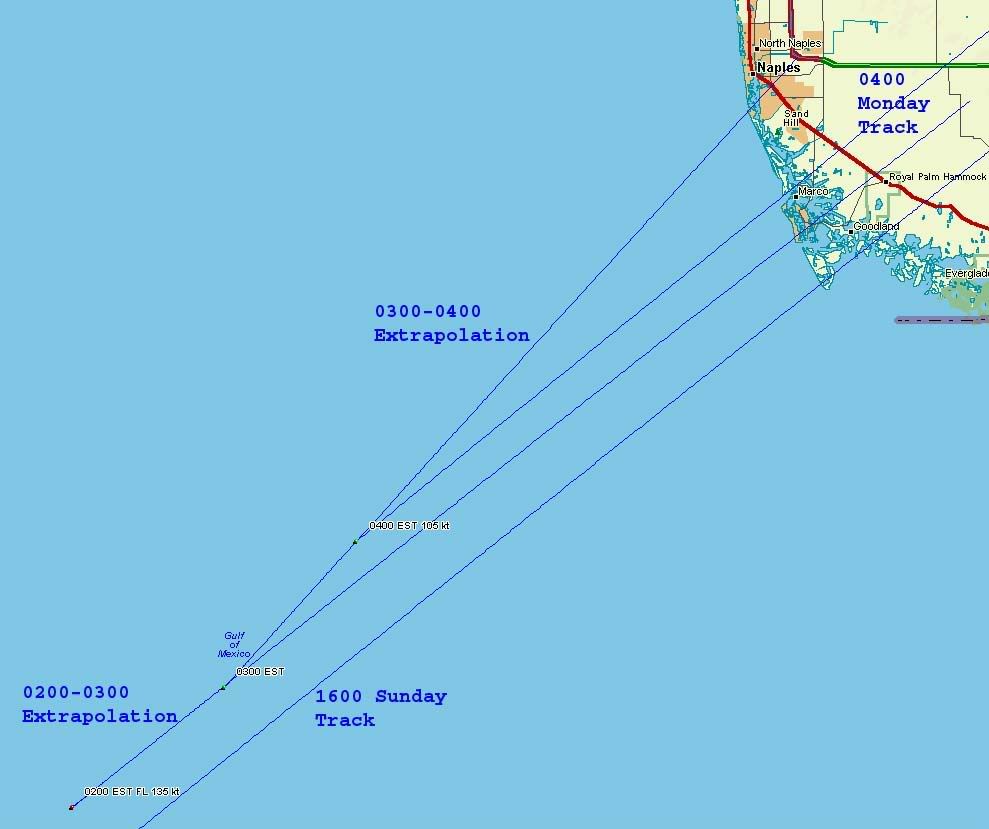
Marco is probably gone. A big part of Naples' future depends on which one of these four lines approximates reality the closest:
http://i4.photobucket.com/albums/y138/jeffers_mz/Wilma/02landfall.jpg
Any post-Charlie bliss for Ft. Myers and Sanibel is about to suffer a hit.
FWIW, the 1600 Sunday track exits Florida at essentially the same place as the 0400 Monday track, halfway between Hobe Sound and Port Salerno, no real changes in course.
FOR LAKE OKEECHOBEE...A STORM SURGE OF 5 TO 7 FEET ABOVE CURRENT LAKE LEVELS IS
EXPECTED FROM EARLY MORNING TO AROUND NOON MONDAY OVER AREAS INSIDE THE DIKE
FROM LAKEPORT TO CLEWISTON...WITH 2 TO 5 FEET ABOVE CURRENT LAKE LEVELS
ELSEWHERE FROM BUCKHEAD RIDGE SOUTH TO LAKEPORT...AND FROM CLEWISTON THROUGH
PORT MAYACA. THIS WILL CAUSE SOME FLOODING OF LOW AREAS OUTSIDE HOOVER DIKE
PROTECTION INCLUDING TORRY...KREAMER AND RITTA ISLANDS AND SOME ACCESS ROADS.
THE LAKE LEVEL ON SUNDAY WAS 15.6 FEET ABOVE MEAN SEA LEVEL.
Disclaimer: Opinions posted on Free Republic are those of the individual posters and do not necessarily represent the opinion of Free Republic or its management. All materials posted herein are protected by copyright law and the exemption for fair use of copyrighted works.