Posted on 10/24/2005 2:18:01 AM PDT by NautiNurse
Category Three Major Hurricane Wilma is barreling toward the Southwest Florida coastline. The storm is packing wind speeds of 125mph, moving NW at 20mph, with an enormous eye 65 miles in diameter. Landfall is anticipated shortly in Collier County between 6:00 and 7:00AM ET.
Storm surge flooding of 9 feet to 17 feet is possible along the coast near and to the south of where Wilma makes landfall. Storm surge of 5 to 8 feet is predicted for the Keys. The storm has spawned tornados throughout the Florida peninsula since yesterday evening.
The following links are self-updating:
Public Advisory Currently published every 3 hours 0500, 0800, 1100 etc. ET
NHC Discussion Published every six hours 0500, 1100, 1700, 2300 ET
Three Day Forecast Track
Five Day Forecast Track
Wilma Forecast Track Archive
Forecast Models
Buoy Data SE Florida
Current Weather Warnings and Watches for Florida
Florida Department of Emergency Management
Images:
Storm Floater IR Loop
Visible Storm Floater Still (only visible during daylight hours)
Color Enhanced Atlantic Loop
Florida Radar/Sat Loop Caution: Broadband users only
Extra Large Miami Radar Broadband only
Extra Large Key West Radar Broadband only
Miami Long Range Radar Loop
Key West Long Range Radar Loop
Miami Radar Still Image w/watches warnings
Melbourne Radar Still Image w/watches warnings
Key West Radar Still Image w/watches warnings
Tampa Bay Radar Still image w/watches warnings
Streaming Video:
WBBH-TV/WZVN-TV Ft. Myers (WMP): http://waterbc.wm.llnwd.net/waterbc_netvideo
WESH-TV/DT Orlando/Daytona Beach (RP): http://mfile.akamai.com/7883/live/reflector:24028.ram
WFTV-TV/DT Orlando (RP): http://mfile.akamai.com/7883/live/reflector:20361.ram
WKMG-TV/DT Orlando (RP): http://mfile.akamai.com/7883/live/reflector:23942.ram
WPBF-TV/DT West Palm Beach (RP): http://mfile.akamai.com/7883/live/reflector:24035.ram
WSVN-TV/DT Miami (WMP): http://216.242.118.140/windowsmedia/asx/wsvn_broadband.asx
WTVJ-TV/DT Miami: http://nbc6.feedroom.com/iframeset.jsp?ord=381015
WPLG-TV/DT Miami (RP): http://mfile.akamai.com/8660/live/reflector:23941.ram
WFOR-TV/DT Miami (WMP): http://wfor.dayport.com/viewer/content/special.php?Art_ID=612&Format_ID=2&BitRate_ID=8&Contract_ID=2&Obj_ID={obj_id}
WTSP-TV/DT St. Petersburg/Tampa (WMP): mms://wmbcast.gannett.speedera.net/wmbcast.gannett/wmbcast_gannett_sep252004_1915_64623
Hurricane City (Real Player) - http://hurricanecity.com/live.ram
ABCNews Now (Real Player) - http://reallive.stream.aol.com/ramgen/redundant/abc/now_hi.rm
Additional Resources:
Pet Friendly Florida Shelter Info
Central Florida Hurricane Center
Hurricane City
CrownWeather.com
| Category | Wind Speed | Barometric Pressure | Storm Surge | Damage Potential |
|---|---|---|---|---|
| Tropical Depression |
< 39 mph < 34 kts |
Minimal | ||
| Tropical Storm |
39 - 73 mph 34 - 63 kts |
Minimal | ||
| Hurricane 1 (Weak) |
74 - 95 mph 64 - 82 kts |
28.94" or more 980.02 mb or more |
4.0' - 5.0' 1.2 m - 1.5 m |
Minimal damage to vegetation |
| Hurricane 2 (Moderate) |
96 - 110 mph 83 - 95 kts |
28.50" - 28.93" 965.12 mb - 979.68 mb |
6.0' - 8.0' 1.8 m - 2.4 m |
Moderate damage to houses |
| Hurricane 3 (Strong) |
111 - 130 mph 96 - 112 kts |
27.91" - 28.49" 945.14 mb - 964.78 mb |
9.0' - 12.0' 2.7 m - 3.7 m |
Extensive damage to small buildings |
| Hurricane 4 (Very strong) |
131 - 155 mph 113 - 135 kts |
27.17" - 27.90" 920.08 mb - 944.80 mb |
13.0' - 18.0' 3.9 m - 5.5 m |
Extreme structural damage |
| Hurricane 5 (Devastating) |
Greater than 155 mph Greater than 135 kts |
Less than 27.17" Less than 920.08 mb |
Greater than 18.0' Greater than 5.5m |
Catastrophic building failures possible |
Previous Threads:
Hurricane Wilma Live Thread, Part III
Hurricane Wilma Part II
Hurricane Wilma Live Thread
Tropical Storm Wilma
Tropical Depression #24
If the governor was bashing the President and the federal response, they would have carried the presser all the way through.
< /sarcasm>
I wonder how much of the response to earlier FL storms was actually due to FEMA under Brown's direction, and how much was due to Jeb. Brown was touting in LA after the disaster his experience in Florida. I wonder if he actually performed in Florida or whether was just along in a support role while Jeb made all the decisions, but the totality of the effort made Brown look good.
On the cleanup, I saw an early morning story on Fox which showed the difference in storm damage in one city on the east coast between an older multistory office building with every floor damaged (broken glass, facades damaged or missing) and a modern multistory condo built after the codes were strengthened after Andrew. No obvious damage at all including windows. Very impressive.
Yea, we were lucky. I must say though, it was more fierce than what was projected. I was scared for the first hour or two. I didn't think it would ever end. Good lesson to be learned. Never underestimate the power of even a cat one hurricane.
Vero is a nice town with some very fine people. Kind of a little know jewel. My son-in-law grew up there.
October 25, 2005
Outage numbers by county
As of 11 am
Affected Counties Out Restored Affected
Alachua - - -
Baker - - -
Bradford - - -
Brevard 10,000 69,500 79,500
Broward 856,900 5,900 862,800
Charlotte 1,600 6,900 8,500
Clay - - -
Collier 126,400 43,200 169,600
Columbia - - -
DeSoto 900 4,000 4,900
Flagler - 200 200
Glades 2,500 900 3,400
Hendry 5,800 2,700 8,500
Highlands 400 - 400
Indian River 39,400 2,200 41,600
Lee 163,600 31,300 194,900
Manatee 2,800 11,800 14,600
Martin 82,200 2,400 84,600
Miami-Dade 908,700 47,800 956,500
Nassau - - -
Okeechobee 14,600 1,300 15,900
Palm Beach 641,800 21,700 663,500
Putnam - 100 100
Sarasota 4,400 14,200 18,600
Seminole - 1,100 1,100
St. Johns - - -
St. Lucie 101,900 1,000 102,900
Suwannee - - -
Union - - -
Volusia 100 9,200 9,300
TOTAL 2,964,000 277,400 3,241,400
http://www.fpl.com/storm/contents/wilma_outage.shtml
I don't have cable tv and since Rosa Parks died our local news is 100% tributes --didn't even get weather or Red Wing highlights last night. I have scoured the online news for, and can't find any, info on:
Singer Island. I have a niece with relatives on the island that no one has heard from.
Flooding between Naples & Marco south of 41 -- Fiddler's Creek in particular. My Dad's stuck in Naples proper & has no idea how his home fared.
Any info would be *greatly* appreciated.
Hurricane Wilma: By the numbers
By Daily News
Tuesday, October 25, 2005
A look at how Hurricane Wilma has affected and will affect our daily lives.
Top Wind Speeds
Naples Airport 121 mph
Everglades City 97 mph
Collier Emergency Operations Center 125 mph
Southwest Florida International Airport 75 mph
Page Field in Fort Myers 68 mph
Bonita Springs 80 mph
Fort Myers Beach 100 mph
Port Charlotte 61 mph
Arcadia 59 mph
WINK-TV in Fort Myers 71 mph
Bellasera Hotel in Naples 86 mph
Cape Coral Elementary 80 mph
http://stormedition.naplesnews.com/news/2005/oct/25/wilma_numbers/
Additional news concerning SW Florida at:
http://stormedition.naplesnews.com/
Atlantic Tropical Weather Outlook TROPICAL WEATHER OUTLOOK NWS TPC/NATIONAL HURRICANE CENTER MIAMI FL 1130 AM EDT TUE OCT 25 2005 FOR THE NORTH ATLANTIC...CARIBBEAN SEA AND THE GULF OF MEXICO... THE NATIONAL HURRICANE CENTER IS ISSUING ADVISORIES ON HURRICANE WILMA... LOCATED ABOUT 570 MILES EAST-NORTHEAST OF CAPE HATTERAS NORTH CAROLINA AND 440 MILES SOUTH-SOUTHWEST OF HALIFAX NOVA SCOTIA. AN AREA OF DISTURBED WEATHER HAS FORMED OVER THE SOUTHWESTERN CARIBBEAN SEA. SOME SLOW DEVELOPMENT OF THIS SYSTEM IS POSSIBLE DURING THE NEXT DAY OR SO. ANOTHER AREA OF DISTURBED WEATHER...ASSOCIATED WITH A WESTWARD- MOVING TROPICAL WAVE...IS LOCATED ABOUT 550 MILES EAST OF THE SOUTHERN WINDWARD ISLANDS. UPPER-LEVEL WINDS ARE NOT CURRENTLY FAVORABLE FOR DEVELOPMENT. ELSEWHERE...TROPICAL STORM FORMATION IS NOT EXPECTED THROUGH WEDNESDAY. FORECASTER BEVEN
Just read that Bonita Springs got nailed. I see that you haven't posted since before Wilma landed.
You okay?
Hopefully you're aware that this is pure dumb luck; Charley was a very narrow storm with limited surge that struck north of you, and the exact center of Wilma went a hair south of you, meaning you missed the right-side surge of the storm.
Eventually Marco Island will be wiped clean; just a matter of time.
I am so glad you are ok and I am sorry to hear about any damage to your propery. It was not very bad here N. of Orlando except for tornadoes. Glad everyone is helping one another there.
"Hurricane season is over."
Marak wrote:
"The expected surge on Marco did not occur, just as it has not in any of the previous hurricanes."
Four things protected Marco Island from Wilma's surge.
1. Wilma was accelerating as she made landfall, which can leave much of the surge behind. Very sparse anecdotal evidence tends to support this.
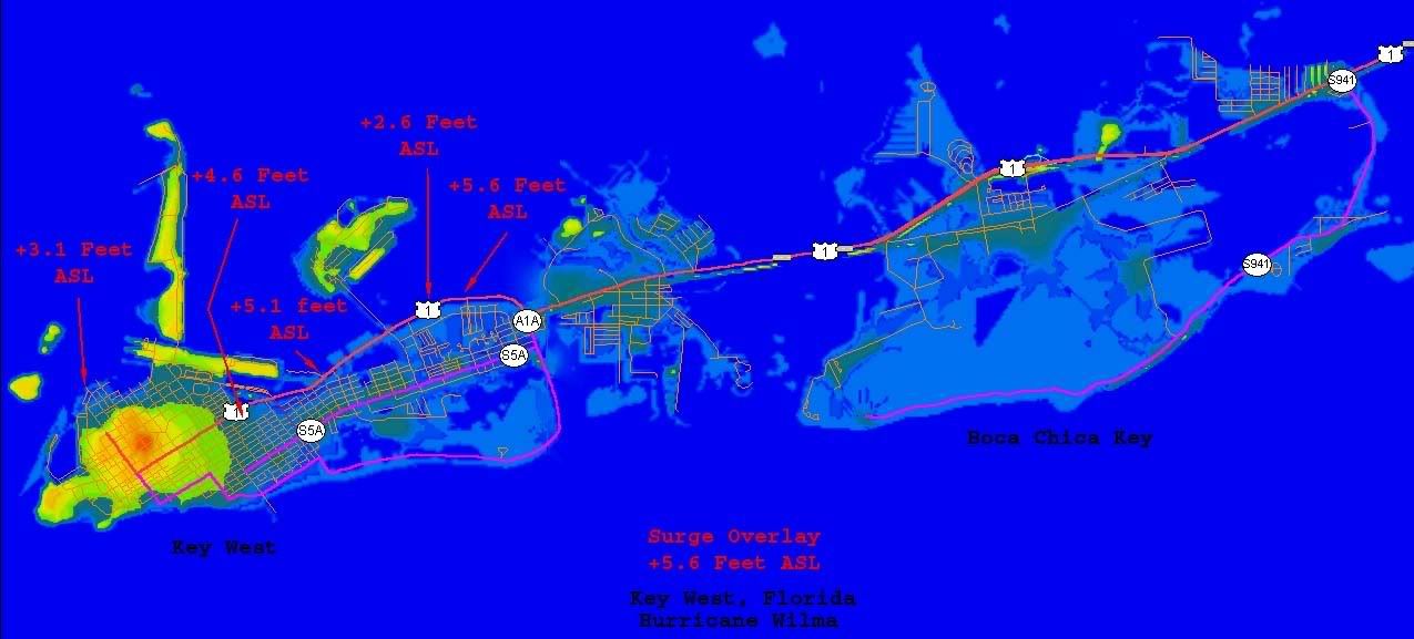
2. Wilma was strengthening as she made landfall. With Katrina, which was weakening at landfall, a Cat-5 surge accompanied a Cat-3 storm. Wilma demonstrated the opposite, a Cat-1 surge with a Cat-3 storm. The highest surge levels documented from anywhere in the Florida area was +5.6 feet ASL, nowhere near the projected 9 to 18 foot surges from pre-storm estimates. Wind accumulates and dissipates faster than water.
3. Wilma made a last second right hook just at landfall, placing Marco Island on the clean side of the storm. The strike geometry was especially beneficial with the curve of Wilma's right front quadrant perfectly matching Florida's concave coastlaine between Marco Island and Flamengo. As the outer eyewall made landfall, it ran inshore and parallel to the coastline all along the most dangerous arc of the storm. It couldn't push water onto the land, because it wasn't over ocean to begin with.
4. The old legend which protects Marco Island is still in effect, and now, will never die.
From Florida Power & Light's Website:
FPL currently has a restoration team in the field of 6,000 -- including approximately 2,500 out-of-state contractors and utility workers. However, it is possible that customers will not see them working as they will be spread across the 22,000 square-mile territory that was hit by the hurricane.
FPL began assessment of damage to its electric grid yesterday and will continue today, but it will take days to complete the assessment effort.
There is extensive damage to FPL’s transmission lines and substations. Our primary focus in the early part of the restoration effort is to get these repaired. Concurrently, FPL is working to restore service to critical infrastructure to facilitate the work of those who provide for community health, safety and public welfare – such as hospitals, police, fire, communications and water, sanitary and transportation providers. FPL already has been in contact with all county emergency operations centers that have been activated as a result of the storm. FPL will maintain these communications with our community partners to be sure vital services are restored as quickly as possible.
FPL is asking customers to NOT call to report an outage. Please call only if there is a situation that presents a clear and imminent danger. Also please do not call again if you have already reported such a condition. Because of the wide swath of damage from Wilma, FPL is aware of many downed lines, so it may be days before restoration crews can get to all of them.
FPL thanks our customers for their patience and understanding as the FPL team works around the clock to restore power and help our communities get back to normal.
FPL Group, with annual revenues of more than $10 billion, is nationally known as a high quality, efficient, and customer-driven organization focused on energy-related products and services. With a growing presence in 26 states, it is widely recognized as one of the country's premier power companies. Its principal subsidiary, Florida Power & Light Company, serves 4.3 million customer accounts in Florida. FPL Energy, LLC, an FPL Group wholesale electricity generating subsidiary, is a leader in producing electricity from clean and renewable fuels. Additional information is available on the Internet at www.FPLGroup.com, www.FPL.com and www.FPLEnergy.com.
I've put up some images displaying accumulated post Wilma data.
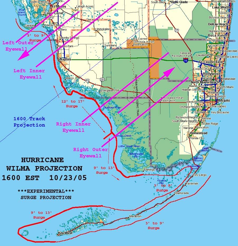
For comparison purposes, this is what was predicted before the storm:
http://i4.photobucket.com/albums/y138/jeffers_mz/Wilma/01Projection.jpg
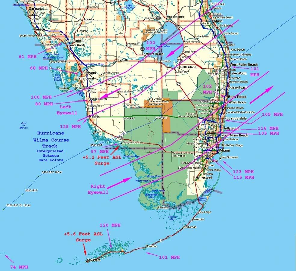
This is what we actually got:
http://i4.photobucket.com/albums/y138/jeffers_mz/Wilma/03assessment2.jpg
Special thanks to NautiNurse and Flaattorney for links to surge and windspeed data.
The storm track displayed on the above image ignores the 0600 NHC datapoint located due north of Everglades City. I believe this plot was derived from radar interpretation of a very ragged eye and was placed inaccurately. Both radar and satellite data from the landfall period support this conclusion. It is possible (probable in my opinion) that the eye center dropped even further south than shown. Radar and satellite imagery indicated that the inner radius of Wilma's eyewall early exactly matched Florida's concave shoreline south of Marco Island at 0502 EST:
http://i4.photobucket.com/albums/y138/jeffers_mz/Wilma/05eyewall.jpg
It is possible that the center of circulation at 0500 was actually as much as 15 miles SSE of the NHC position. There were data anomalies with the 0400 plot, which was released, retracted, then re-released as discussed in this thread, and the 0600 plot is well out of line with the wobble recovery indicated by the 0400, 0500 and 0700 plots.
With significant questions surrounding the 0400 and 0600 plots and the data from other sources, I conclude that the 0500 plot is inaccurate. I used it for this image because it does not significantly affect the true landfall or eyewall locations.
Windspeeds indicated on this image are partly official measured gusts, and partly unofficial measured gusts. Keep in mind that many anemometers failed before registering peak sustained or gust speeds when attempting to reconstruct Wilma's windfields.
http://i4.photobucket.com/albums/y138/jeffers_mz/Wilma/03subassessment1.jpg
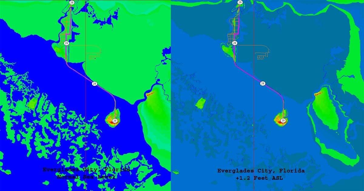
This image was rendered from 3 meter per pixel Digital Elevation Models and shows normal sea levels and artificially induced sea levels at Everglades City. The artificial level is at 1.2 feet ASL to demonstrate the normal elevation for Everglades City. This, in conjunction with anecdotal reports of four foot deep surge at that location during the height of the storm, was used to derive the final figure used in the overall assessment image.
http://i4.photobucket.com/albums/y138/jeffers_mz/Wilma/04subassessment2.jpg
This image was rendered from 10 meter per pixel Digital Elevation Models and shows Key West and the adjacent Boca Chica Key at artificial surge levels of +5.6 feet ASL. This represents the maximum surge level derived from anecdotal reports, which are indicated by the red arrows.
I strongly suspect that higher surge levels occurred between Everglades City and Key West, but am so far unable to document or estimate them. I'm in the process of statistically modelling surge distribution profiles for various storm parameters and hope to have that completed in time for next year's hurricane season.
I'm also working on modelling the frequent circulation center "right hooks" at landfall demonstrated by this year's storms so as to be able to indicate them or at least the potential for them on pre-storm projection imagery in the future.
If anyone is waiting for me to admit the pre-storm map includes projections that did not actually take place, I hereby so admit.
I was wrong. I apologize for that, and for any negative benefits that may have resulted from those errors.
I will also admit that given the same conditions, I would post those projections again, even with the benefit of hindsight. Those projections are based on the best available data at the time, and I believe their utility outweigh the possible consequences of error. Use them accordingly.
That's not to say I'm comfortable with error, I'm not. I know what elements were accurate, which ones turned out to be inaccurate, and am working on improving the shortfalls.
I seriously doubt that our predictive ability will ever be perfect, but that's no reason not to try.
Thanks for your concern. I have not heard of any injuries yet from the Marco Island area, so maybe we were blessed.
I was fortunate enough to have my daughter and two of her friends come down from Orlando to help us prepare the house for Wilma's onslaught. Without their help I probably would have lost the house.
...and the sound of chainsaws is comforting music after a storm.
"It's! ..." [cue "Monty Python's Flying Circus" intro theme music]
...forget it, I can't even begin to say the "B" word...
"I was wrong. I apologize for that"
I think it was you that posted the storm surge map for Collier county. That's what finally got my dad out of his one-story condo between the coast & the everglades.
Thanks. Better safe than floating. No apology necessary.
Disclaimer: Opinions posted on Free Republic are those of the individual posters and do not necessarily represent the opinion of Free Republic or its management. All materials posted herein are protected by copyright law and the exemption for fair use of copyrighted works.