| This thread has been locked, it will not receive new replies. |
|
Locked on 10/24/2005 2:24:18 AM PDT by Jim Robinson, reason:
New thread: http://www.freerepublic.com/focus/news/1508056/posts |
Posted on 10/22/2005 1:25:10 PM PDT by NautiNurse
Hurricane Wilma slowly drifts toward the Southeast Gulf of Mexico after relentlessly pounding Cozumel and Cancun for more than 24 hours. Early reports indicate extensive wind and flood damage to Mexico's resort-studded Mayan Riviera. Mexican officials said about 20,000 tourists were at shelters and hotels on the mainland south of Cancun and an estimated 10,000-12,000 were in Cancun itself. About 50 hotels were evacuated.
In preparation for Hurricane Wilma's anticipated Florida landfall, a Hurricane Watch and mandatory evacuation have been issued for the Florida Keys and Florida Bay. Mandatory evacuations for Marco Island and much of Naples are in effect, as well as high surf advisories and high risk of rip currents along Florida's panhandle and Big Bend coasts. Bus services are available for Monroe Co. and other counties for residents who do not have transportation. Additional storm watches for the Florida peninsula are expected later today.
The 2005 hurricane season altered the record books again today with the formation of Tropical Storm Alpha south of Hispanola. Preliminary forecasts indicate TS Alpha will not affect the U.S. mainland.
The following links are self-updating:
Public Advisory Currently published every 3 hours 0500, 0800, 1100 etc. ET
NHC Discussion Published every six hours 0500, 1100, 1700, 2300 ET
Three Day Forecast Track
Five Day Forecast Track
Wilma Forecast Track Archive
Forecast Models
Buoy Data SE Florida
Current Weather Warnings and Watches for Florida
Florida Department of Emergency Management
Images:
Storm Floater IR Loop
Visible Storm Floater Still (only visible during daylight hours)
Color Enhanced Atlantic Loop
Florida Radar/Sat Loop Caution: Broadband users only
Extra Large Miami Radar Broadband only
Extra Large Key West Radar Broadband only
Miami Long Range Radar Loop
Key West Long Range Radar Loop
Miami Experimental Radar Still Image
Key West Experimental Radar Still Image
Streaming Video:
WBBH-TV/WZVN-TV Ft. Myers (WMP): http://waterbc.wm.llnwd.net/waterbc_netvideo
WESH-TV/DT Orlando/Daytona Beach (RP): http://mfile.akamai.com/7883/live/reflector:24028.ram
WFTV-TV/DT Orlando (RP): http://mfile.akamai.com/7883/live/reflector:20361.ram
WKMG-TV/DT Orlando (RP): http://mfile.akamai.com/7883/live/reflector:23942.ram
WPBF-TV/DT West Palm Beach (RP): http://mfile.akamai.com/7883/live/reflector:24035.ram
WSVN-TV/DT Miami (WMP): http://216.242.118.140/windowsmedia/asx/wsvn_broadband.asx
WTVJ-TV/DT Miami: http://nbc6.feedroom.com/iframeset.jsp?ord=381015
WPLG-TV/DT Miami (RP): http://mfile.akamai.com/8660/live/reflector:23941.ram
WFOR-TV/DT Miami (WMP): http://wfor.dayport.com/viewer/content/special.php?Art_ID=612&Format_ID=2&BitRate_ID=8&Contract_ID=2&Obj_ID={obj_id}
WTSP-TV/DT St. Petersburg/Tampa (WMP): mms://wmbcast.gannett.speedera.net/wmbcast.gannett/wmbcast_gannett_sep252004_1915_64623
Hurricane City (Real Player) - http://hurricanecity.com/live.ram
ABCNews Now (Real Player) - http://reallive.stream.aol.com/ramgen/redundant/abc/now_hi.rm
Additional Resources:
Pet Friendly Florida Shelter Info
Central Florida Hurricane Center
Hurricane City
CrownWeather.com
| Category | Wind Speed | Barometric Pressure | Storm Surge | Damage Potential |
|---|---|---|---|---|
| Tropical Depression |
< 39 mph < 34 kts |
Minimal | ||
| Tropical Storm |
39 - 73 mph 34 - 63 kts |
Minimal | ||
| Hurricane 1 (Weak) |
74 - 95 mph 64 - 82 kts |
28.94" or more 980.02 mb or more |
4.0' - 5.0' 1.2 m - 1.5 m |
Minimal damage to vegetation |
| Hurricane 2 (Moderate) |
96 - 110 mph 83 - 95 kts |
28.50" - 28.93" 965.12 mb - 979.68 mb |
6.0' - 8.0' 1.8 m - 2.4 m |
Moderate damage to houses |
| Hurricane 3 (Strong) |
111 - 130 mph 96 - 112 kts |
27.91" - 28.49" 945.14 mb - 964.78 mb |
9.0' - 12.0' 2.7 m - 3.7 m |
Extensive damage to small buildings |
| Hurricane 4 (Very strong) |
131 - 155 mph 113 - 135 kts |
27.17" - 27.90" 920.08 mb - 944.80 mb |
13.0' - 18.0' 3.9 m - 5.5 m |
Extreme structural damage |
| Hurricane 5 (Devastating) |
Greater than 155 mph Greater than 135 kts |
Less than 27.17" Less than 920.08 mb |
Greater than 18.0' Greater than 5.5m |
Catastrophic building failures possible |
Previous Threads:
Hurricane Wilma Part II
Hurricane Wilma Live Thread
Tropical Storm Wilma
Tropical Depression #24
naw the fish are wet anyway.
I say new thread, might as well, now that it is about to make meaningful landfall (no disrespect meant to the Keyes), it would probably be a good idea to have a fresh thread.
My plot shows a slight shift to the left / north with that last position but the direction of 50 degrees should bring that back to the right. The 1800z estimate in the 5AM has Wilma exiting at Jupiter, Fl. Looks like closest approach to casa NVA is about 100 miles. That would be fine if this witch wasn't spitting out tornadoes in the neighborhood. :)
http://www.intellicast.com/Local/USLocalWide.asp?loc=usflct24906&seg=LocalWeather&prodgrp=RadarImagery&product=RegionalRadarLoop&prodnav=none&pid=none
Getting ready for a touchdown! :-)
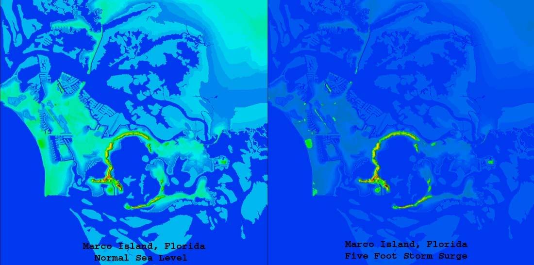
What do you think the storm serge will be on Marco Island?
Stupid Cantore tricks - Jungle Jim's doing his reports from a moored fishing boat in Key Largo now.
Speaking of stupid Cantore tricks, Stephanie Abrams pretty much tops him; she's still out on the docks in Naples as the outer eyewall looks to be coming in. Even the ducks don't want any part of this one.
Please don't. I really have had it with people downplaying this and claiming things that have no relation to the reality. I'm not in the mood for it.
Hey - how are you holding up?
That's a tough call, because on the current track, Marco is right near the left edge of max surge, where it starts falling off rapidly. Same spot in Katrina saw 15 feet, while elsewhere saw 30+.
With forecasts still calling for 17 foot on the upper end, Marco could see half that as a minimum. This slight left shift we're seeing right now could put that up to 13 to 15 easily.
Here's what Marco Island will look like with a five foot surge:
http://i4.photobucket.com/albums/y138/jeffers_mz/Wilma/marcoplus5.jpg
Was Stephanie Abrams the hamburger wind story teller on CNN?
Lack of sleep got to me a while back, as if I just hit a wall. Not in a good mood at all.
Al Rokker was still in Naples as of last night too.
I'm hoping we don't have to stomach Katie chatting back and forth with Al while he clings to a telephone pole.
Hi laz,
Praying you stay safe! (o:
-LR
I know this is minor but we're getting rain here in Charleston from Wilma. The coastal rain from Wilma runs all the way up well into North Carolina.
I heard on ABC Miami a few minutes ago that they're predicting up to 18 feet.
Check this out, awesome shear on the western face of the inner eyewall. It's been there for two frames now, so it might not be an artifact.
http://www.intellicast.com/Local/USLocalWide.asp?loc=kbyx&seg=LocalWeather&prodgrp=NEXRADimagery&product=RadialVelocity&prodnav=none
076
URNT12 KNHC 240859
VORTEX DATA MESSAGE
A. 24/08:39:50Z
B. 25 deg 29 min N
  082 deg 19 min W
C. 700 mb 2684 m
D. NA  kt
E.     deg     nm
F. 208 deg 123 kt
G. 135 deg 040 nm
H.         953 mb
I.   9 C/ 3032 m
J.  14 C/ 3042 m
K.  13 C/ NA
L. CLOSED WALL
M. C60
N. 12345/ 7
O. 0.02 / 3  nm
P. AF302 2524A WILMA        OB 10
MAX FL WIND 123 KT SE QUAD 08:28:30 Z
MAX FL TEMP 15 C, 134 / 30NM
Movement from the first AF302 fix at 3:47 - 75 degrees at 20 mph. Movement from the last AF305 fix at 2:59 - 53 degrees at 24 mph.
Disclaimer: Opinions posted on Free Republic are those of the individual posters and do not necessarily represent the opinion of Free Republic or its management. All materials posted herein are protected by copyright law and the exemption for fair use of copyrighted works.