| This thread has been locked, it will not receive new replies. |
|
Locked on 10/24/2005 2:24:18 AM PDT by Jim Robinson, reason:
New thread: http://www.freerepublic.com/focus/news/1508056/posts |
Posted on 10/22/2005 1:25:10 PM PDT by NautiNurse
naw the fish are wet anyway.
I say new thread, might as well, now that it is about to make meaningful landfall (no disrespect meant to the Keyes), it would probably be a good idea to have a fresh thread.
My plot shows a slight shift to the left / north with that last position but the direction of 50 degrees should bring that back to the right. The 1800z estimate in the 5AM has Wilma exiting at Jupiter, Fl. Looks like closest approach to casa NVA is about 100 miles. That would be fine if this witch wasn't spitting out tornadoes in the neighborhood. :)
http://www.intellicast.com/Local/USLocalWide.asp?loc=usflct24906&seg=LocalWeather&prodgrp=RadarImagery&product=RegionalRadarLoop&prodnav=none&pid=none
Getting ready for a touchdown! :-)
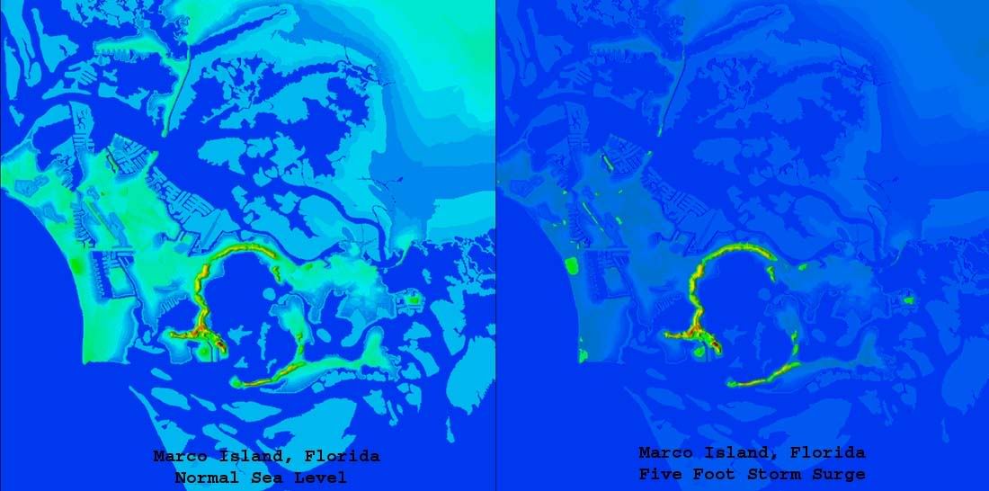
What do you think the storm serge will be on Marco Island?
Stupid Cantore tricks - Jungle Jim's doing his reports from a moored fishing boat in Key Largo now.
Speaking of stupid Cantore tricks, Stephanie Abrams pretty much tops him; she's still out on the docks in Naples as the outer eyewall looks to be coming in. Even the ducks don't want any part of this one.
Please don't. I really have had it with people downplaying this and claiming things that have no relation to the reality. I'm not in the mood for it.
Hey - how are you holding up?
That's a tough call, because on the current track, Marco is right near the left edge of max surge, where it starts falling off rapidly. Same spot in Katrina saw 15 feet, while elsewhere saw 30+.
With forecasts still calling for 17 foot on the upper end, Marco could see half that as a minimum. This slight left shift we're seeing right now could put that up to 13 to 15 easily.
Here's what Marco Island will look like with a five foot surge:
http://i4.photobucket.com/albums/y138/jeffers_mz/Wilma/marcoplus5.jpg
Was Stephanie Abrams the hamburger wind story teller on CNN?
Lack of sleep got to me a while back, as if I just hit a wall. Not in a good mood at all.
Al Rokker was still in Naples as of last night too.
I'm hoping we don't have to stomach Katie chatting back and forth with Al while he clings to a telephone pole.
Hi laz,
Praying you stay safe! (o:
-LR
I know this is minor but we're getting rain here in Charleston from Wilma. The coastal rain from Wilma runs all the way up well into North Carolina.
I heard on ABC Miami a few minutes ago that they're predicting up to 18 feet.
Check this out, awesome shear on the western face of the inner eyewall. It's been there for two frames now, so it might not be an artifact.
http://www.intellicast.com/Local/USLocalWide.asp?loc=kbyx&seg=LocalWeather&prodgrp=NEXRADimagery&product=RadialVelocity&prodnav=none
076
URNT12 KNHC 240859
VORTEX DATA MESSAGE
A. 24/08:39:50Z
B. 25 deg 29 min N
  082 deg 19 min W
C. 700 mb 2684 m
D. NA  kt
E.     deg     nm
F. 208 deg 123 kt
G. 135 deg 040 nm
H.         953 mb
I.   9 C/ 3032 m
J.  14 C/ 3042 m
K.  13 C/ NA
L. CLOSED WALL
M. C60
N. 12345/ 7
O. 0.02 / 3  nm
P. AF302 2524A WILMA        OB 10
MAX FL WIND 123 KT SE QUAD 08:28:30 Z
MAX FL TEMP 15 C, 134 / 30NM
Movement from the first AF302 fix at 3:47 - 75 degrees at 20 mph. Movement from the last AF305 fix at 2:59 - 53 degrees at 24 mph.
Disclaimer: Opinions posted on Free Republic are those of the individual posters and do not necessarily represent the opinion of Free Republic or its management. All materials posted herein are protected by copyright law and the exemption for fair use of copyrighted works.