
Posted on 11/30/2025 7:19:53 PM PST by Red Badger
The idea of nations as neatly bordered spaces can be traced partly to medieval maps of biblical Israel.
In A Nutshell
Medieval Christian maps showing the twelve tribes of Israel featured clear boundary lines centuries before most other maps depicted political borders
These religious maps, created to illustrate spiritual inheritance, inadvertently became the model that Renaissance cartographers followed when drawing territorial boundaries on secular maps
By the 1600s, the visual language of bordered territories had become so normalized that English scholars began interpreting biblical texts as describing precisely surveyed nation-states, even though those passages originally made different points
The relationship worked both ways: biblical maps influenced how Europeans drew political borders, while the spread of border-focused maps changed how people read and understood the Bible itself
==================================================================
Medieval Christians drawing boundaries around ancient Israelite tribes on Holy Land maps had no idea they were influencing how later mapmakers would depict political power. Those red ink lines, meant to show spiritual inheritance, became an important model for how nations would mark their territories for centuries to come.
A study published in The Journal of Theological Studies reveals that Christian maps of biblical Israel played a significant role in the development of nations with fixed borders. Nathan MacDonald, a University of Cambridge researcher, traced how tribal territories drawn on medieval religious maps became a template for marking political boundaries on maps of European countries, eventually spreading across atlases worldwide.
The discovery adds a twist to the usual story about the origins of bordered nation-states. Most scholars credit the rediscovery of ancient Greek geographer Ptolemy’s work in the 1400s for introducing boundary lines to European cartography. MacDonald found that mapmakers were already drawing clear borders on Holy Land maps based on medieval Christian traditions, and these religious maps helped set the standard that secular maps eventually followed.
From Sacred Borders to Political Boundaries
Medieval Christians created detailed maps showing where the twelve tribes of Israel supposedly lived, with red ink marking the borders between tribal territories. These weren’t meant to show political power but rather to illustrate the spiritual inheritance that Christians believed they had received from the biblical Israelites.
When Renaissance scholars started producing modern atlases in the late 1400s, they copied these Holy Land maps and included them alongside newly updated maps of contemporary Europe and Asia. The 1482 Ulm printing of Ptolemy’s Geography featured Pietro Vesconte’s grid map of the Holy Land with all twelve tribal territories clearly marked.
The tribal boundary lines on these religious maps started influencing how cartographers thought about depicting any territory. In 1570, just 45 percent of maps in Abraham Ortelius’s Theatrum atlas included boundaries. By 1658, that figure had jumped to 98 percent in Nicolas Sanson’s atlas of French provinces. Maps of the Holy Land, which had been showing boundaries all along, led the way.
The Medieval Monk Behind the Holy Land Maps
German Dominican monk Burchard of Mount Sion created an influential description of the Holy Land in the late 1200s. More than 60 manuscript copies of his work circulated across medieval Europe.
Venetian statesman Marino Sanudo later used Burchard’s geographical descriptions in his early 1300s appeal for a new crusade, the Liber Secretorum Fidelium Crucis. Sanudo provided detailed instructions for producing a grid map with tribal territories marked. Italian mapmaker Pietro Vesconte, working closely with Sanudo, turned these instructions into actual maps around 1300.
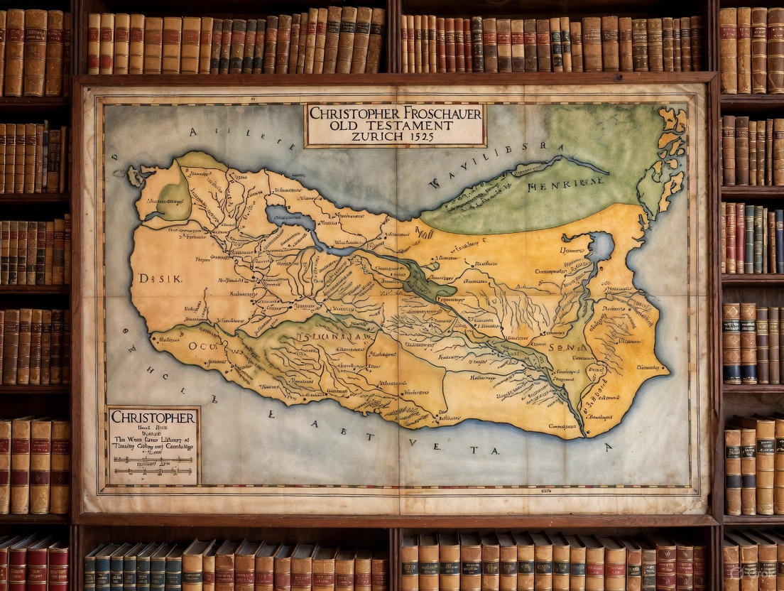
Vesconte’s maps spread throughout Europe and later appeared in the first modern atlases. Protestant Bibles also adopted this mapping tradition. A 1525 Bible published in Zurich by Christopher Froschauer included a map of the Holy Land by Lukas Cranach showing both the wilderness wanderings and the tribal division of the Promised Land. By the mid-1500s, maps of tribal territories became standard features in Protestant Bibles.
The earliest surviving map in the Burchard-Sanudo-Vesconte tradition, dating to around 1300, stretches more than five feet wide and shows mountains, towns with battlements, and tribal territories marked with red boundary lines.
The tribal boundaries on these maps weren’t based on extensive geographical knowledge. Medieval Europeans had limited information about the actual geography of ancient Israel. Instead, mapmakers followed biblical descriptions and the work of first-century Jewish historian Josephus, who had simplified the complicated tribal allotments described in the Book of Joshua.
For medieval Christians, these tribal territories carried deep religious meaning. Burchard’s description begins by explaining that “the land which we call ‘holy,’ which fell to the lot of the twelve tribes of Israel” was later divided into the kingdoms of Judah and Samaria. The tribal territories represented Christian claims to inherit the sacred landscape of the Bible.
When Burchard wrote about the crusader fortress of Safed falling to Muslim forces in 1188, he lamented the loss not just of physical territory but of “the land of the tribes Zabulun, Naphtali, Asher, Issachar, and Manasseh, and the whole land as far as Acre, Tyre, and Sidon.” Invoking the tribal names communicated that this land was the rightful Christian inheritance.
Medieval Christian theology interpreted the Israelites’ conquest and division of the Promised Land as foreshadowing the salvation brought by the Gospel. Just as the biblical figure Joshua led the Israelites into their inheritance, Christians believed Jesus (the same name in Hebrew) led believers into spiritual inheritance. The tribal territories on maps weren’t about political sovereignty but about visualizing eternal promises.
But as these maps moved from religious contexts into general atlases, their meaning transformed. Lines that once symbolized spiritual inheritance began representing political sovereignty.
How Biblical Interpretation Changed With Maps
MacDonald tracked this transformation by analyzing how English scholars interpreted the biblical “Table of Nations” in Genesis 10, which describes how Noah’s descendants spread across the earth after the great flood.
In the late 1500s, English chroniclers understood this passage as describing broad continental divisions. Noah’s son Japheth’s descendants populated Europe, Ham’s descendants settled Africa, and Shem’s descendants occupied Asia. The chroniclers didn’t imagine precise territorial borders between different peoples, and biblical commentator Andrew Willet in 1633 acknowledged that the division was messy, with “some of each were intermingled.”
By the mid-1600s, that interpretation had changed dramatically. Legal scholar John Selden, in his influential 1635 treatise arguing that nations could claim sovereignty over surrounding seas, interpreted Genesis 10 as describing a precise division of the world into bounded territories. Selden wrote that Noah’s descendants “settled themselves as private Lords, and appointed Bounds according to the number of their Families from the River Tanais even as far as the Atlantick Sea.”
Selden imagined Noah’s descendants conducting land surveys and drawing boundary lines. He even interpreted biblical references to the Mediterranean Sea as the western boundary of the Promised Land as describing “a strait line drawn from the entrance of Nilus to the Promontorie of Mount Hor,” cutting through the sea itself to mark Israel’s territorial waters.
By the early 1700s, English biblical scholar Matthew Henry described the division of lands among Japheth’s sons as being “solemnly, by lot, after a survey, divided among them, and probably this island of ours among the rest.” Another commentator, Joseph Mede, explained in 1672 that the allocation “could be done no otherwise but by instituting an orderly Division” with “portions border’d out according to the number of their Nations.”
MacDonald argues that the relationship between maps and biblical interpretation worked both ways. Medieval Christian maps of tribal territories helped spread the visual language of bounded political space to other maps. But as that visual language became normal, it changed how people read the Bible, making boundary-focused interpretations seem natural even in passages where borders weren’t the original point.
Maps and the Birth of Modern Nationalism
For medieval Christians like Burchard of Mount Sion, tribal boundaries represented the timeless presence of biblical history in the landscape of Israel. For early modern legal theorists like Selden, those same tribal boundaries provided biblical precedent for the modern system of territorial nation-states.
One revealing detail: the earliest Jewish maps of the land of Israel from the medieval period showed schematic borders of the overall territory but didn’t emphasize individual tribal boundaries. That focus was distinctively Christian, related to claims about spiritual inheritance rather than political sovereignty. Jewish legal scholars cared about the land’s borders because certain religious laws only applied within those boundaries, not because of political theories about statehood.
MacDonald’s research suggests a nuanced picture. The Bible genuinely influenced early modern political thinking about territorial sovereignty and national boundaries. But readers were simultaneously projecting contemporary ideas about bordered nation-states back onto biblical texts that were actually making different points about divine promises and spiritual inheritance.
Maps both reflected and accelerated political change. When Renaissance cartographers included Vesconte’s medieval Holy Land map in their editions of Ptolemy’s Geography alongside maps of contemporary Europe, they were combining two different systems of understanding space. The Holy Land map showed spiritual geography with clear boundaries. The other maps initially showed political geography without clear boundaries. Over time, the secular maps adopted the boundary-marking style of the religious maps.
Protestant Bibles played a major role in spreading these boundary-focused maps beyond scholarly circles. By the mid-1500s, Protestant publishers regularly included maps of the tribal division of the Promised Land, typically placed at Joshua 15 to illustrate the biblical text describing how the land was allocated to the twelve tribes.
For Bible readers, the maps suggested that the Book of Joshua, despite its contradictions and textual difficulties, could be understood as a coherent account that divided the land of Israel into twelve distinct, contiguous territories. The biblical text took on features of a Renaissance geography text, with complicated verbal descriptions that could be transformed into a map.
The research draws on analysis of maps from major collections including multiple editions of Ptolemy’s Geography from 1482 onward, medieval manuscript maps, early Protestant Bibles, and Renaissance atlases by famous cartographers. MacDonald also examined biblical commentaries and legal treatises from England between the 1500s and 1700s to track how interpretations of biblical geography changed alongside cartographic developments.
Ping!............
I’m not completely sure what I am looking at?
A map of the Israelite’s division of the Land of Canaan...........
The biblical descriptions of the tribe allotments are very specific and detailed. When reading the text, it’s as though one is looking at a map.......................
Practically every Bible I own has some form of maps in the back.
One has the divisions of the land among the tribes, the voyages of Paul, the world after the Flood, etc...........
I don’t believe north is up.
I looked the best I could but I did not see Judah.
It’s in LATIN!...............
IVDA...............
The Jews resided in Judah.
Septentrio = North
fake map. where’s palestine?
/sarcasm
On the map, the tribal names are written in Latin. Judah is IVDA in Latin...................
Indeed. Maybe AI could deal with this. I asked Grok: Can you access this image and recreate it as the locations would be named today: https://studyfinds.org/wp-content/uploads/2025/11/Christopher-Froschauer_Old-Testament_Zurich-1525_The-Wren-Library_Trinity-College_-Cambridge_Credit_The-Master-and-Fellows-of-Trinity-College_Cambridge-1200x885.jpg.webp
It provided:
Grok helped, but it is not there yet. paging SunkenCiv
Perplexity.ai said:
It’s not possible to reliably read and transcribe the place‑names from that specific image via this interface, so the image itself can’t be faithfully “recreated” with updated modern labels.
However, maps like the one you linked (a 1525 Old Testament map by Christoph Froschauer) typically show the main biblical/ancient regions, which correspond roughly to these modern areas:
Israel / Judah → modern Israel and Palestinian territories
Philistia → coastal Israel and Gaza area
Phoenicia → Lebanon (coast) and parts of coastal Syria
Aram / Syria → modern Syria
Ammon, Moab, Edom → modern Jordan and parts of southern Israel / northwest Saudi Arabia
Assyria → northern Iraq, parts of northeastern Syria, southeastern Turkey
Babylonia / Chaldea → central and southern Iraq
Media / Persia → western and central Iran
Egypt → modern Egypt (mainly Nile valley / delta)
Arabia / Arabia Deserta / Felix → Arabian Peninsula (Saudi Arabia, Yemen, Oman, UAE, etc.)
Asia Minor → modern Türkiye
Mesopotamia → Iraq plus parts of Syria and southeastern Turkey
If you can give a list of the specific historical names you see on the map (or a cropped close‑up of the labels), a one‑to‑one table mapping each to its closest modern country/region name can be created.
It’s the Middle East; the blue splashes are I suspect Lake Van etc, the NW-to-SE rivers are the Euphrates/Tigris/etc, running to the Persian Gulf. Probably this is a 16th c interpretation of surviving Byzantine/Roman texts and maps that haven’t made it to our time.
bump
Oh, a thousand pardons.
No problem! I had to look myself!...............
Thx.
Disclaimer: Opinions posted on Free Republic are those of the individual posters and do not necessarily represent the opinion of Free Republic or its management. All materials posted herein are protected by copyright law and the exemption for fair use of copyrighted works.