
link
Posted on 07/18/2012 7:13:03 AM PDT by marshmallow
Buildings of different purposes, rising out of lakes and rivers, submerged in gallons of water - the places where people once lived and worked, a homes to weeds and fishes now. These buildings were flooded and drowned by men's own doing, in their hurry to change nature's path for dams and reservoirs. Churches, monasteries, palaces and fortresses are usually occur as partly-submerged structures, which are popular among photographers and tourists.
1. St. Nicholas Church, Macedonia
The church of St. Nicholas in Mavrovo, Macedonia was built in 1850 and stood for a 153 years until it was decided an artificial lake was needed in the village. At one point the church was fully submerged, but it keeps rising again, especially in summer with the droughts of the 21st century. [link, map]
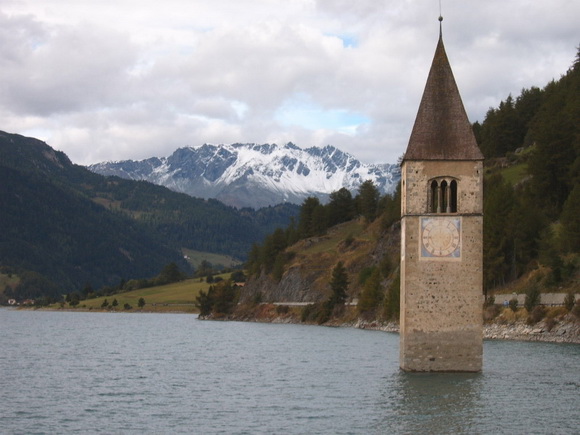
2. Church Of Altgraun In Lake Reschen, Italy
Planning for a man made lake in this area began in the 1920’s by the Montecatini company, who wanted to build the reservoir for electricity. This proved difficult as they could not get proper support and met strong resistance from all towns involved.
After years of delays and appeals to government officials, the villages of Graun and Reschen were submerged in 1950. A total of 163 homes were lost, including the famous church, whose clock tower still stands above 20 feet (6 m) of water, and has become a main attraction of the area. [link, map]
(Excerpt) Read more at theworldgeography.com ...
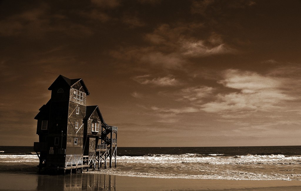
I took this picture a few summers ago at Cape Hatteras. It's the house from the movie "Nights in Rodanthe". After filming, a tropical storm or hurricane (I forget which) took some of the beach out from under the house, leaving it in the water.
Later, they came in and actually moved the house to the sound side of Hatteras Island.
I first became interested when, as a younger man, I'd hustle house painting contracts for good, quick money, and the first funeral home I painted really drilled home to me the (lost) art of a coping saw.
The word 'gingerbread' perfectly describes the intricate (sometimes functional) decorations under the eaves.
THAT started me looking at churches and the masonry involved.
By that time I was hooked.
NOW I see so much that I know, "Some man's hands did that .. and those hands are dead, and no one cared enough to learn what those hands did"
Thanx marshmallow for this fascinating bit of history.
Knarf you should consider writing/documenting these things. So much craft has been lost. You may have insights that are valuable and interesting to others?
Apparently there are parts of the coast of England which have subsided over many centuries and various small towns and churches are now under the waves.
If you posted your comment as-is, it would look like ...
If you posted your comment as-is, it would look like ... Towns disincorporated
The Massachusetts Quabbin Reservoir’s creation in the 1930s required the flooding, and thus the disincorporation, in April 1938, of four towns: Dana (located in Worcester County), Enfield, Greenwich, and Prescott (all located in Hampshire County). The land remaining from the disincorporated towns was added to surrounding municipalities, including Belchertown, Pelham, New Salem, Petersham, Hardwick and Ware. One additional town on the reservoir is Shutesbury, in Franklin County. Because of New Salem’s annexation of the Prescott Peninsula, a large wedge of land shifted from Hampshire County to Franklin County. Today, the majority of the reservoir lies in either New Salem or Petersham.
In addition, thirty-six miles of the Boston and Albany Railroad’s Athol Branch were abandoned (originally the Springfield, Athol and Northeastern Railroad). Route 21, formerly reaching Athol, was truncated to the south side of the reservoir, and new roads—now US 202 and Route 32A—were built on each side.
When the buildings in the towns flooded by the reservoir were destroyed, the cellars were left intact. Old roads that once led to the flooded towns can be followed to the water’s edge. Not all elements of the towns were flooded, however. Town memorials and cemeteries in the four towns were moved to Quabbin Park Cemetery, located on Route 9 in Ware, just off the Quabbin’s lands. Many other public buildings were moved to other locations. For example, the Prescott First Congregational Church was moved to South Hadley. [4]
Three student housing facilities at Hampshire College in Amherst are named after the discontinued towns of Greenwich, Prescott, and Enfield. In addition, Hampshire College named another facility on its campus Dana House after the other discontinued town of Dana.
Four residence halls at nearby the Eagle Hill School are also named for the four towns - Greenwich, Prescott, Dana and Enfield. Posted on 07/18/2012 8:36:34 AM PDT by pabianice ( ) To: (use semi-colons to separate multiple recipients) Your Reply: (HTML auto-detected, see help for more information) Tagline: (optional, printed after your name on post): I have already previewed or do not wish to preview this composition. Please: NO profanity, NO personal attacks, NO racism or violence in posts. Posting HTML This forum allows optional use of most HTML tags. If your post does not contain HTML, it will be converted to HTML when posted, retaining paragraphs as typed. This conversion is not performed if you have anything resembling an HTML tag in your text.
Posted on 07/18/2012 8:37:23 AM PDT by pabianice ( )
Auto-preview in effect. Click Post again to submit your comment.
To: (use semi-colons to separate multiple recipients)
Your Reply: (HTML auto-detected, see help for more information)
Tagline: (optional, printed after your name on post):
I have already previewed or do not wish to preview this composition.
Loose lips sink ships.
Posting HTML
This forum allows optional use of most HTML tags. If your post does not contain HTML, it will be converted to HTML when posted, retaining paragraphs as typed. This conversion is not performed if you have anything resembling an HTML tag in your text.
I just spent over an hour on that site looking through the slide shows (Worlds deepest lakes etc....)It has some amazing photos on it.
thanks for posting!
I probably messed up your whole morning!
For home perusement.


True story,,,a town near columbus ohio was flooded when they built a local damn.I used to tell me cousins storys about the flooded town.There was an old road that you could walk on right until it went underwater.They were supposed to move the graveyards,caskets etc.I would tell them that all they moved were the tombstones and left behind the bodies to save money.They thought it was just a ghost story.But 20 years later caskets with bodies started floating to the surface.
I love that Hatteras shot.
15 years or so ago, we vacationed just up the road from Hatteras in Nags Head, and we had the one house (at least that we could see from where we were) that was on the ocean side of the dunes. High tide had the water up under the front half of the house.
Ahh, the town of Oakland Mills, Maryland, submerged beneath the Liberty reservoir.
I walk the fire roads with my dogs ... most of them are remnants of the roads that existed prior to the reservoir. Hard not to be intersted in the history.
Disclaimer: Opinions posted on Free Republic are those of the individual posters and do not necessarily represent the opinion of Free Republic or its management. All materials posted herein are protected by copyright law and the exemption for fair use of copyrighted works.
