Posted on 10/09/2024 6:09:13 PM PDT by TBP
Not that many people lived in Florida before 1970 so it wasn’t a big deal if a hurricane hit Florida back then.

“Oldtimers” know the deal. Unfortunately, we have a society run by village idiots born after 2000.
Just look where palm trees and live oaks are most populated.
Palm trees are more abundant where the winds can be bad because they are growing with the right structure to withstand high winds.
Live oaks are not very wind resistant, at least compared to palms and takes a long time to reach maturity.
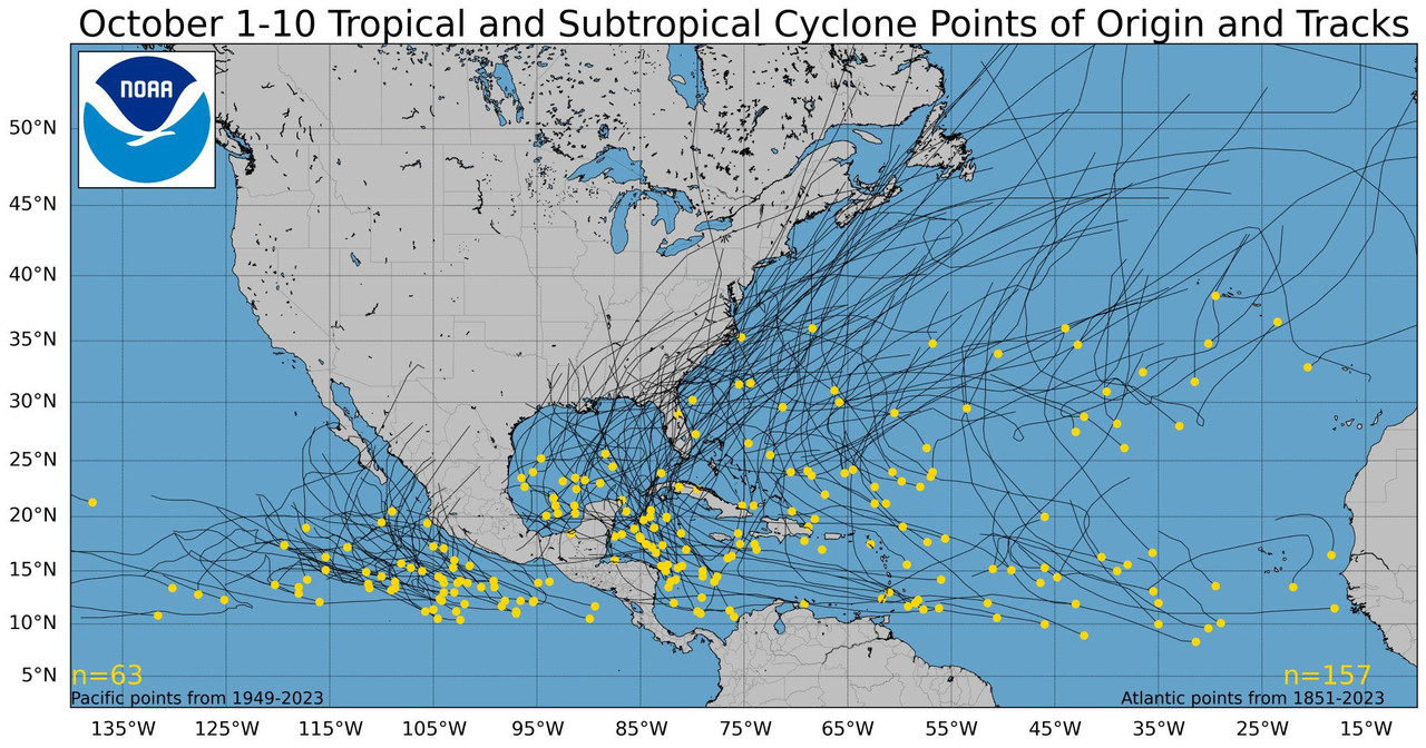
Did a three year old get a hold of this map behind the meteorologists back?😜😜
Live oaks are highly wind resistant.
The deadliest hurricane in US history did not hit Florida. It was the hurricane that hit Galveston, TX in 1900. Estimated death toll was 4000, plus it almost totally wiped out the City of Galveston. It also changed the course of Texas history. Prior to this hurricane, Galveston was the busiest and most important port in Texas, but port activity moved almost completely to Houston due to damage to Galveston.
It is clear from that map that the Deep State has been controlling the direction of hurricanes since 1949.
And they really hate Florida!
What happens to the man eating alligators. Do they get killed or survive like cockroaches being displaced in the flood waters of the neighborhoods
Let me toot my deceased Dad's horn for him. He managed parts of the Nimbus satellite program which put the very first earth-facing environmental satellite in orbit. I don't recall if he worked on Nimbus after the first two were launched.
The Nimbus satellites were second-generation U.S. robotic spacecraft launched between 1964 and 1978 used for meteorological research and development. The spacecraft were designed to serve as stabilized, Earth-oriented platforms for the testing of advanced systems to sense and collect atmospheric science data. Seven Nimbus spacecraft have been launched into near-polar, Sun-synchronous orbits beginning with Nimbus 1 on August 28, 1964. On board the Nimbus satellites are various instrumentation for imaging, sounding, and other studies in different spectral regions. The Nimbus satellites were launched aboard Thor-Agena rockets (Nimbus 1–4) and Delta rockets (Nimbus 5–7).Then Dad went on to manage the Earth Resources Technology Satellite ("ERTS") which was later renamed to "Landsat."Over a 20-year period from the launch of the first satellite, the Nimbus series of missions was the United States' primary research and development platform for satellite remote sensing of the Earth. The seven Nimbus satellites, launched over a fourteen-year period, shared their space-based observations of the planet for thirty years.
The Landsat program is the longest-running enterprise for acquisition of satellite imagery of Earth. It is a joint NASA / USGS program. On 23 July 1972, the Earth Resources Technology Satellite was launched. This was eventually renamed to Landsat 1 in 1975. The most recent, Landsat 9, was launched on 27 September 2021.The instruments on the Landsat satellites have acquired millions of images. The images, archived in the United States and at Landsat receiving stations around the world, are a unique resource for global change research and applications in agriculture, cartography, geology, forestry, regional planning, surveillance and education, and can be viewed through the U.S. Geological Survey "EarthExplorer" website. Landsat 7 data has eight spectral bands with spatial resolutions ranging from 15 to 60 m (49 to 197 ft); the temporal resolution is 16 days. Landsat images are usually divided into scenes for easy downloading. Each Landsat scene is about 115 miles long and 115 miles wide (or 100 nautical miles long and 100 nautical miles wide, or 185 kilometers long and 185 kilometers wide).
later
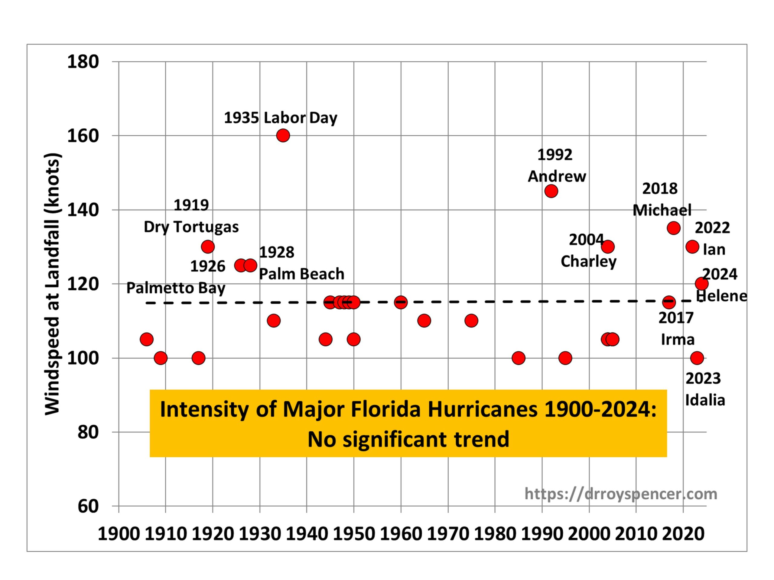
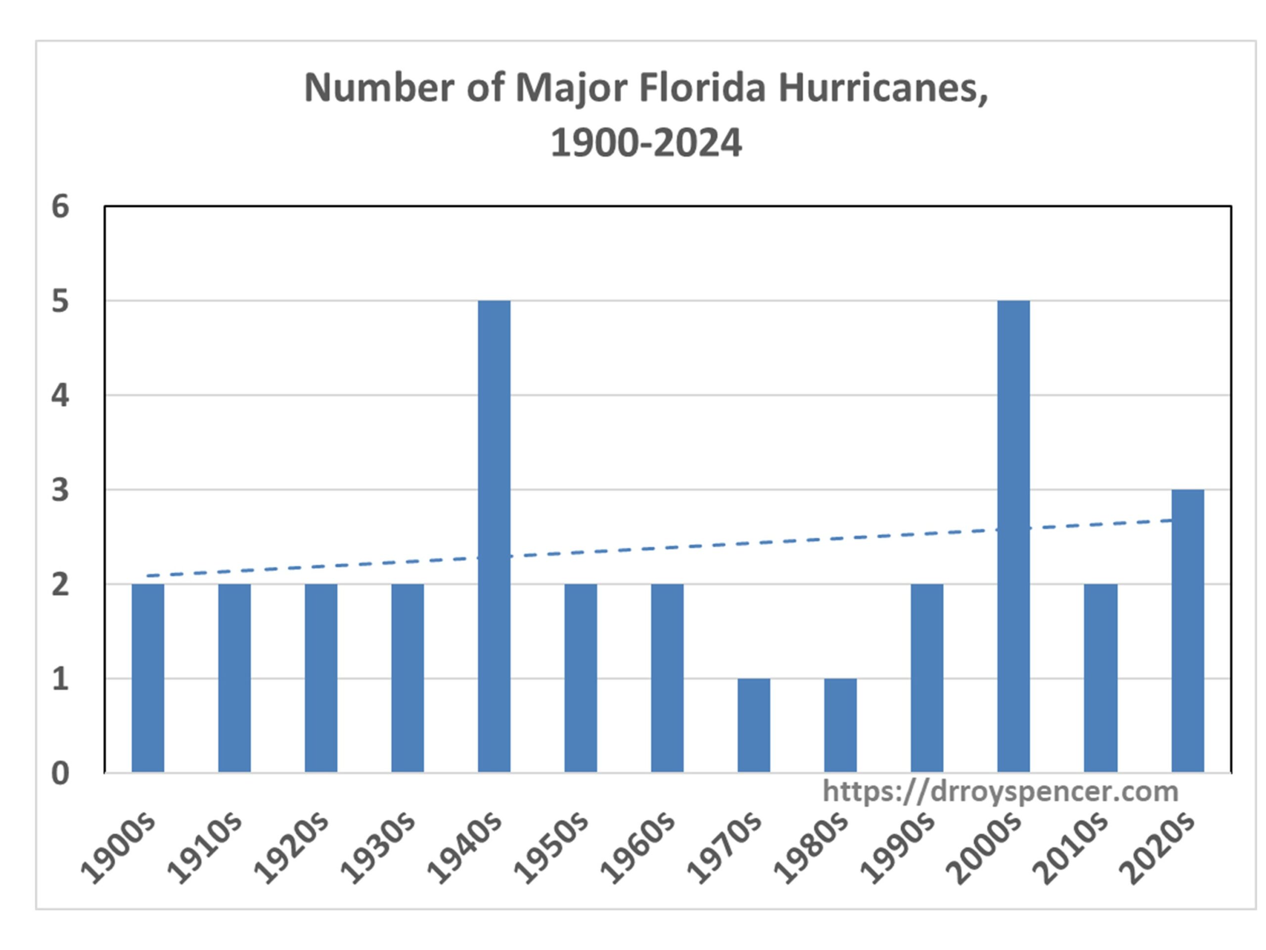
Are the graphs big enough for you?
Holy Moley — those stats are huge!

Better?

Precede the usual "img src" html with "img height = 400".
Scaling is easy once you get the hang of it.
I recall our good FRiend, TBP, having similar issues of magnitude in the past. Or perhaps it was a Great Wall of Text... lol
90% of what I know about html coding I learned on FReep.
And it took me about 15 years to FINALLY learn how to do image scaling.
Disclaimer: Opinions posted on Free Republic are those of the individual posters and do not necessarily represent the opinion of Free Republic or its management. All materials posted herein are protected by copyright law and the exemption for fair use of copyrighted works.