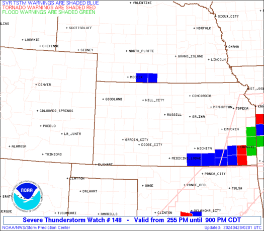
RED = Tornado Warrning
Posted on 04/19/2023 8:47:46 PM PDT by Paul R.
Live coverage of the April 19th, 2023 severe weather event!
(Excerpt) Read more at youtube.com ...
VIDEO: Large and dangerous tornado on the ground doing damage in Shawnee, OK as it crossed I-40 near the mall
https://rumble.com/v2jbgdc-large-and-dangerous-tornado-on-the-ground-doing-damage-in-shawnee-ok.html

RED = Tornado Warrning
Plenty of TV coverage has been coming out of Oklahoma City TV stations too. More damage reports coming in, pics of hail nearly the size of baseballs.
One fatality in Cole, OK, so far, LEO is saying due to the damage they are seeing, there may well be more, LEO’s working to get people out of shelters they are trapped in.
Of note is that the reporters are saying OK has a system to register shelters with the state. That sounds like a REALLY good idea. I am thinking that in states without such a system, maybe it is possible to advise one’s Sheriff or local police of such?
OBU (Christian University in Shawnee, OK) has some damage, some students wandering around unable to go back in dorms apparently? It’s very hard to say with pics @ night, but I’d say there’s some F2 damage, at least one dorm brick wall was seriously dsmaged.
Interesting rehash @ the TV link above. Notable were at least a couple storms the moved initially as expected, from the SW, but then turned & went North or even a bit NNW.
“damaged”

Prayers Up for my good FRiends in Tulsa.
Bookmarking.
Hope the tornadoes skip over Glenpool and Kiefer.
It looks like the big supercell is staying south of Tulsa and now beginning to lose some strength. Thank goodness!
Prayers up for everyone, especially my great-grandchildren in Glenpool and their relatives in Kiefer, and Bixby.
At present it looks like the big supercell should stay south of Glenpool and Kiefer. It seems to be losing some strength, and hopefully will stay that way...
Thank you for that.
Maybe I will be able to sleep tonight.
No prob. That supercell IS still drawing in moisture from the south, so it could well hang in there until it gets to Arkansas. If I had to guess I’d say the worst of it will pass just to the south of Muskogee, tracking just to the north of I-40.
The hailers in Kansas look weaker too, but are not dead yet, and are still generating severe t-storm warnings.
Thanx for the link & report
Disclaimer: Opinions posted on Free Republic are those of the individual posters and do not necessarily represent the opinion of Free Republic or its management. All materials posted herein are protected by copyright law and the exemption for fair use of copyrighted works.