
Posted on 09/09/2018 8:01:18 AM PDT by NautiNurse
September 10 is the statistical peak of the Atlantic Tropical Storm season, and the conga line of storms dancing across the Atlantic is not disappointing historical data. The Governors of NC and SC have declared states of emergency for a potential major hurricane landfall, while Hurricane Florence is slowly creeping westward. Florence is predicted to increase forward motion and intensity Monday. Hurricanes Hazel (1954) and Hugo (1989) are two notorious major hurricanes to make landfall in NC and SC, respectively. North Carolina has prior experience with "F" named hurricanes. Hurricanes Fran (1996) and Floyd (1999) caused widespread flooding and damage in the Tar Heel state.
The NHC has been issuing Public Advisories for Florence since August 30. The five day "Cone of Uncertainty" archive progression since Aug. 30 may be found here.
Isaac is a small storm. Isaac is predicted to steadily strengthen during the next few days as the storm remains over warm waters and in a low wind shear environment in the short term. The NHC predicts Isaac will reach hurricane status within 2 days.
Helene is expected to reach hurricane status in the short term. However, Helene is not anticipated to threaten U.S. interests. The forecast track turns north into the mid-Atlantic.
Click on the images below to enlarge

I post this article because there is a 34 item 'prep list' contained within the article.
I think of this eye wall grinding along the coast from this point to the southwest and I hope everyone goes to Kentucky today.


Amazing photo—and beautiful in a scary way.

I had a professional friend whose home was hit by Katrina in Gulfport Miss.
It also completely totaled his business and records.
Finally, he had a vacation home in New Orleans, also destroyed.
He struggled for two years to try to put his life together, and then committed suicide, leaving a wife and family.
Great guy. Big loss for his family.
down to cat 3.... BUT huge
Hurricane Florence Intermediate Advisory Number 53A
NWS National Hurricane Center Miami FL AL062018
200 PM EDT Wed Sep 12 2018
...FLORENCE’S PEAK WINDS HAVE DECREASED SLIGHTLY BUT THE SIZE OF THE
WIND FIELD HAS INCREASED...
...LIFE-THREATENING STORM SURGE AND RAINFALL EXPECTED ACROSS
PORTIONS OF THE CAROLINAS...
SUMMARY OF 200 PM EDT...1800 UTC...INFORMATION
Prayers....
Trump needs to have a conference call with all the state governors and record him telling them to not wait to declare a state of emergency, and that they will be responsible for any delay in tge federal response. Then relaese it to tge media
Up to 200 people decided to stay on Ocracoke Island, NC. There is no road to the island, ferry service has now stopped, emergency response has now stopped. They have decided to stay on an island that might go underwater. Don't be that person.
-- Jamie Mitchem (@DrMitchem) September 12, 2018

On/Off Hurricane List Mash Here--> 
The large construction company I was with did hundreds of millions in work on the Gulf Coast after Katrina. I was down there to bid on work in that area. I was in Gulf Port a few weeks after Katrina but way up on the interstate. The motel we met in had drywall that had been wet to 32” above floor level. This was up on Interstate 10.
I’ve posted on another thread about this. This storm has an Ike feel to it.
It’s going to sit and spin and pile up surge for days. All that rainfall along the coast will have nowhere to go. Total nightmare situation for anyone lower than 30’ above sealevel at the coast. And just about anyone lower than 2nd or 3rd floor inland.
Harvey + Ike would be disaster.
IMO this is Harvey+Ike+Matthew. Stalling out. Bad rain. Bad surge. Hugging the coast.

Up to 200 people decided to stay on Ocracoke Island, NC. There is no road to the island, ferry service has now stopped, emergency response has now stopped. They have decided to stay on an island that might go underwater. Don't be that person.
11:37 AM - Sep 12, 2018 - 87 - 75 people are talking about this
https://twitter.com/DrMitchem/status/1039915826831388677
Gotta hope that is wrong. Wikipedia shows avg. elevation @ 3 ft., with many structures built on pilings / posts. These people want to join Blackbeard?
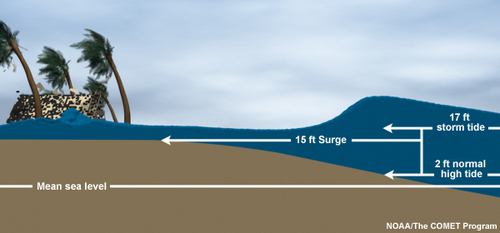
To find peak water height (NOT the same as "inundation") I believe one adds storm surge to normal high tide and then add something for waves -- but if the wave is a breaker... ???
Eh, beat me to it!


Disclaimer: Opinions posted on Free Republic are those of the individual posters and do not necessarily represent the opinion of Free Republic or its management. All materials posted herein are protected by copyright law and the exemption for fair use of copyrighted works.


