Puerto Rico Ping! Please Freepmail me if you want on or off the list.

Posted on 09/12/2017 9:44:45 AM PDT by cll
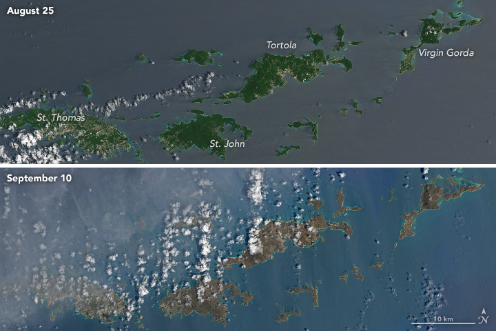
Hurricane Irma churned across the Atlantic Ocean in September 2017, battering several Caribbean islands before moving on to the Florida Keys and the U.S. mainland. As the clouds cleared over places like the Virgin Islands, the destruction became obvious even from space.
These natural-color images, captured by the Operational Land Imager (OLI) on the Landsat 8 satellite, show some of Irma’s effect on the British and U.S. Virgin Islands. The views were acquired on August 25 and September 10, 2017, before and after the storm passed. They are among the few relatively cloud-free satellite images of the area so far.
The most obvious change is the widespread browning of the landscape. There are a number of possible reasons for this. Lush green tropical vegetation can be ripped away by a storm’s strong winds, leaving the satellite with a view of more bare ground. Also, salt spray whipped up by the hurricane can coat and desiccate leaves while they are still on the trees.
Irma passed the northernmost Virgin Islands on the afternoon of September 6. At the time, Irma was a category 5 storm with maximum sustained winds of 185 miles (295 kilometers) per hour. According to news reports, the islands saw “significant devastation.”
East Island Excursions. Telephone (U.S.) 787-860-3434. http://www.eastislandpr.com/
Puerto Rico Ping! Please Freepmail me if you want on or off the list.
Hurricanes are a fact of life in the Caribbean.
Learn to deal with it and prepare.
I was in Tortola, Antigua & Barbuda, and St. Maartin/St. Martin in January of last year. All the sites I remember are now gone, and possibly some of the people I met. Very, very sad.
How do you prepare for brown?
wow...
are there any people left alive there?
Plant a garden.
I wonder if Google Earth and Street View can be updated to show recent changes like this?
Google Earth is overhead satellite imagery. I don’t know for sure but I suspect there’s a subscription service that would provide recent images.
Street scenes are made by a google car with the crazy camera on the roof. At best it’s updated annually in major cities.
Leaves are blown-off the trees. I would imagine that most of them will grow back. Meanwhile, CO2 in the air will increase and cause more global warming, no doubt.
They use cars with roof mounted fish eye type lenses to do the street views so it will probably be several years for updates by which time it will be rebuilt or maybe not. Its a “throwing good money after bad” kind of decision.
So, we’re all gonna die?
Irma devastation ping (Virgin Islands).
Eventually ;’}
What crops were there readying for harvest are gone.
Your link now has its own thread.
We had friends on St. Martin during the hurricane - 95% of the island was destroyed. Took a C130 to get them off the island. It went from a lush, tropical paradise to third world devastation in the blink of an eye.
That looks really bad, like all of the foliage was literally stripped off of those islands.
And guess what? Soon they’ll be green again, just like after every other Hurricane that has come before.
Disclaimer: Opinions posted on Free Republic are those of the individual posters and do not necessarily represent the opinion of Free Republic or its management. All materials posted herein are protected by copyright law and the exemption for fair use of copyrighted works.