Posted on 09/07/2017 8:09:47 AM PDT by NautiNurse
Dangerous Category 5 Hurricane Irma had a devastating impact on islands in the Caribbean.
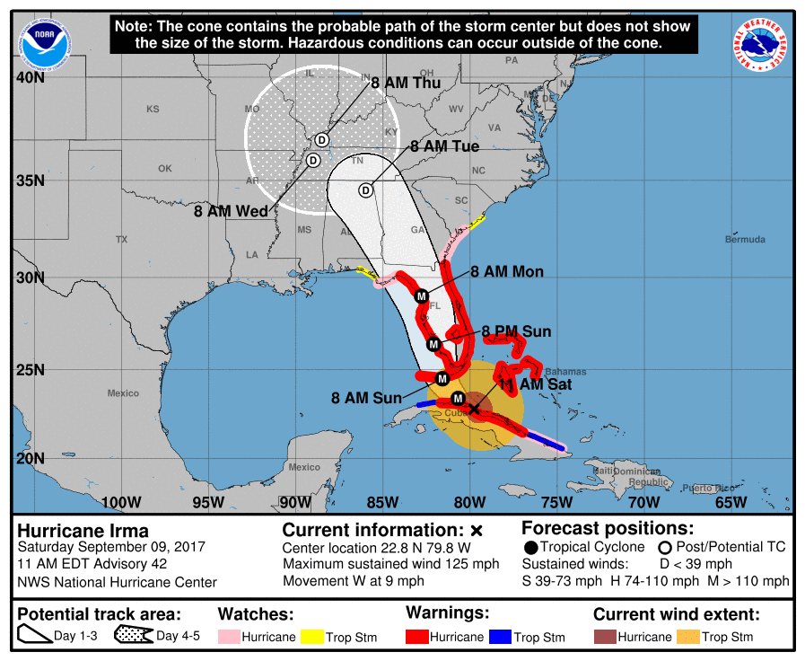
Hurricane and Storm surge watches were issued Thursday morning for South Florida. The Florida Keys began evacuating visitors and residents, followed by flood zones in Miami and Miami Beach. Sarasota FL declared a local state of emergency Thursday morning.
Polk County FL Sheriff Grady Judd said Wednesday that law enforcement authorities would check the identities of people who turn up at shelters--and take to jail anyone found to have an active arrest warrant. “If you go to a shelter for Irma and you have a warrant, we’ll gladly escort you to the safe and secure shelter called the Polk County Jail... “If you have a warrant, turn yourself in to the jail — it’s a secure shelter.” Judd also posted that sex offenders and sex predators would not be admitted to the shelters. "We cannot and we will not have innocent children in a shelter with sexual offenders & predators. Period." Judd's statements unleashed a liberal firestorm via Twitter.

Mash image to find lots of satellite imagery links
Public Advisories
NHC Discussions
NHC Local Weather Statements/Radar Miami, FL
NHC Local Weather Statements/Radar Melbourne, FL
NOAA Local Weather Statements/Radar Jacksonville, FL
NHC Local Weather Statements/Radar Charleston, SC
NHC Local Weather Statements/Radar Wilmington, NC, FL
NHC Local Weather Statements/Radar Morehead City, FL
NHC Local Weather Statements/Radar Norfolk, VA
Buoy Data Caribbean
Buoy Data SE US & GOM
Buoy Data NC/SC/GA
Hebert Box - Mash Pic for Tutorial
Credit: By J Cricket - Modification of map from Wiki
The Weather Channel is holding to their original tracking. The eye is west of Miami but they just showed a graphic of it turning around to head back east to hit Miami.
Heh, just a few hours ago I made the same observation in a text to my cousin. "Right out of Hell, I SAW it..."
Here we are hoping for a more movement west .
It’s a odd storm with many surprises .
To date, they have been very good. They predicted Harvey's landfall near Corpus Christie and they were off by only 50 miles...not too shabby, as well as, accurately predicting 50 inches of rain. And so it was.
Thanks - cool image, but what I actually want is a plot of the center’s track, maybe in 30 minute increments...
That applies all too well...
Still winds at 125mph
Still moving west along the coast of Cuba.
sees to be undergoing gan eye wall replacement again..winds down a bit
LOCATION...23.3N 80.8W
ABOUT 30 MI...45 KM ENE OF VARADERO CUBA
ABOUT 110 MI...175 KM SE OF KEY WEST FLORIDA
MAXIMUM SUSTAINED WINDS...120 MPH...195 KM/H
PRESENT MOVEMENT...WNW OR 290 DEGREES AT 7 MPH...11 KM/H
MINIMUM CENTRAL PRESSURE...932 MB...27.52 INCHES

And NOAA radar out of Key West shows the same trend. Look like Irma has finally made its turn.
Just found two tweets from meteorologists independently suggesting the feared rapid/explosive intensification is now underway.

That's my house it's moondancing around for 3 days in that big circle (worse: Nashville will be flooded, big time).
Dang it... wrong browser window!
~~~~~~~~~~
With "tens of millions of dollars of supercomputers", you just get more garbage out -- faster...
That is one of the major problems with "Climate Change": an infinitesimal error in starting assumptions (or ignoring a single other influencing factor) yields mountainous error after projection. And, the farther out you try to project, the worse the error and divergence gets.
~~~~~~~~~~~~
Nobody (with "tens of millions of dollars of supercomputers") can predict where that huge hurricane will be one day from now. What makes them think that "tens of millions of dollars of supercomputers" can help them forecast the effect of an infinitesimally small change in the infinitesimally small fraction of the atmosphere that is CO2 -- and extend that asinine forecast out across DECADES?
That's especially true when they start with the asinine assumption that a minuscule micro-fraction of a single gas in the entire atmosphere actually affects the whole in any measurable manner -- without tracking the effects of every other possible atmospheric component -- at the same time..
MOOSAKE!!!
Physical chemist sends...
blah...blah...blah
They were only 50 miles incorrect with Harvey and they accurately forecasted 50 inches of rain, but there is always someone who wants to pretend they are smarter and loves to trash someone or a group that actually makes a difference.
Thank you for your prayers. The US military flew Americans to Puerto Rico ahead of the arrival of hurricane Jose. We are all very relieved.
Freeper Travis McGee, an author himself, named himself after the main character in the John MacDonald books.
Disclaimer: Opinions posted on Free Republic are those of the individual posters and do not necessarily represent the opinion of Free Republic or its management. All materials posted herein are protected by copyright law and the exemption for fair use of copyrighted works.