Skip to comments.
Hurricane Irma Live Thread Part II
NHC/NOAA ^
| NHC/NOAA
| NHC/NOAA
Posted on 09/07/2017 8:09:47 AM PDT by NautiNurse
Dangerous Category 5 Hurricane Irma had a devastating impact on islands in the Caribbean.
Hurricane and Storm surge watches were issued Thursday morning for South Florida. The Florida Keys began evacuating visitors and residents, followed by flood zones in Miami and Miami Beach. Sarasota FL declared a local state of emergency Thursday morning.
Polk County FL Sheriff Grady Judd said Wednesday that law enforcement authorities would check the identities of people who turn up at shelters--and take to jail anyone found to have an active arrest warrant. “If you go to a shelter for Irma and you have a warrant, we’ll gladly escort you to the safe and secure shelter called the Polk County Jail... “If you have a warrant, turn yourself in to the jail — it’s a secure shelter.” Judd also posted that sex offenders and sex predators would not be admitted to the shelters. "We cannot and we will not have innocent children in a shelter with sexual offenders & predators. Period." Judd's statements unleashed a liberal firestorm via Twitter.


Mash image to find lots of satellite imagery links
Public Advisories
NHC Discussions
NHC Local Weather Statements/Radar Miami, FL
NHC Local Weather Statements/Radar Melbourne, FL
NOAA Local Weather Statements/Radar Jacksonville, FL
NHC Local Weather Statements/Radar Charleston, SC
NHC Local Weather Statements/Radar Wilmington, NC, FL
NHC Local Weather Statements/Radar Morehead City, FL
NHC Local Weather Statements/Radar Norfolk, VA
Buoy Data Caribbean
Buoy Data SE US & GOM
Buoy Data NC/SC/GA
Hebert Box - Mash Pic for Tutorial
Credit: By J Cricket - Modification of map from Wiki
Hurricane Irma Live Thread I
TOPICS: Breaking News; Extended News; Front Page News; US: Florida; US: Georgia; US: North Carolina; US: South Carolina
KEYWORDS: hurricane; hurricaneirma; hurricanejose; hurricanekatia; irma; livehurricaneirma
Navigation: use the links below to view more comments.
first previous 1-20 ... 1,221-1,240, 1,241-1,260, 1,261-1,280 ... 2,661-2,667 next last
To: alancarp
Slight wobble towards the Cuban coast:

To: nutmeg
1,242
posted on
09/08/2017 1:58:05 PM PDT
by
daniel1212
(Trust the risen Lord Jesus to save you as a damned and destitute sinner + be baptized + folllow Him)
To: dirtboy
Try again....

1,243
posted on
09/08/2017 2:01:12 PM PDT
by
metmom
( ...fixing our eyes on Jesus, the Author and Perfecter of our faith..)
To: NautiNurse
Hannity (radio) just said Joe Bastardi at the bottom of the hour (1/2 hour from now). (Pat Buchanan up next.)
1,244
posted on
09/08/2017 2:01:32 PM PDT
by
snarkpup
(The swamp is draining; and the alligators are allegating.)
To: Oldeconomybuyer
With all due respect to Joe, he is all alone on that one.
1,245
posted on
09/08/2017 2:01:39 PM PDT
by
RightGeek
(FUBO and the donkey you rode in on)
To: alancarp
Didn’t the UKMET have that track early on?
1,246
posted on
09/08/2017 2:01:48 PM PDT
by
thouworm
("To anger a conservative, lie to him. To anger a liberal, tell him the truth"---Theodore Roosevelt)
To: dirtboy
Slight wobble towards the Cuban coast: Oh please! Oh please!
To: abb; abbi_normal_2; aberaussie; abner; AbsoluteGrace; alancarp; Alas Babylon!; Alia; ...
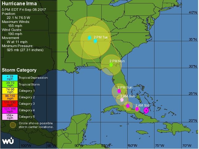
WATCHES AND WARNINGS
--------------------
CHANGES WITH THIS ADVISORY:
The Hurricane Warning has been extended northward for east coast of
Florida to Sebastian Inlet, and along the west coast of the
peninsula northward to Anna Maria Island.
The Hurricane Watch has been extended northward along the west coast
of Florida to Suwannee River.
A Storm Surge Watch has been issued north of Venice to the Anclote
River, including Tampa Bay, and from Ponce Inlet to the Flagler/
Volusia County Line.
SUMMARY OF 0500 PM Advisory...
----------------------------------------------
Location...22.1N 76.5W
About 195 MI...E OF CAIBARIEN CUBA
About 345 MI...SE of Miami FL
Maximum Sustained Winds...155 MPH
Present Movement...W OR 280 DEGREES AT 12 MPH
Minimum Central Pressure...925 MB...27.32 Inches
Hurricane-force winds extend outward up to 70 miles from
the center and tropical-storm-force winds extend outward up to 185
miles. 
On/Off Hurricane List Mash Here--> 
1,248
posted on
09/08/2017 2:03:18 PM PDT
by
NautiNurse
(Tear down the Mexican Carrier plant and use the materials to build the wall)
To: dfwgator
Well, with it making landfall on the western side, that means the worst side of the storm, the right side, with the highest winds and propensity to produce tornadoes, is going up the middle of the state.
1,249
posted on
09/08/2017 2:03:55 PM PDT
by
metmom
( ...fixing our eyes on Jesus, the Author and Perfecter of our faith..)
To: daniel1212
Jose is forecast to loop around and make another try at the Keys.
I am not sure we’ve seen the last of that one.
1,250
posted on
09/08/2017 2:04:51 PM PDT
by
metmom
( ...fixing our eyes on Jesus, the Author and Perfecter of our faith..)
To: NautiNurse
^^^ Forward motion slowing to 12 from 14 mph; still heading West. The storm surge estimates are tremendous for SE Florida.
1,251
posted on
09/08/2017 2:05:33 PM PDT
by
alancarp
(George Orwell was an optimist.)
To: 4everontheRight
On the plane... a few planes ahead of, should take off pretty soon!
To: NautiNurse
Oh,man-—I’ve been to Anna Maria Island-——a lovely place.
.
1,253
posted on
09/08/2017 2:06:23 PM PDT
by
Mears
To: Qiviut
Excellent info for post-storm return home—thank you for the post!
1,254
posted on
09/08/2017 2:07:22 PM PDT
by
NautiNurse
(Tear down the Mexican Carrier plant and use the materials to build the wall)
To: onemiddleamerican
Palm Bay, Fla is in Central Florida
I use to live there!
To: All
my sister was in Homestead when Andrew hit. They were staying at the million dollar home of her husbands boss.
The roof caved in on them and they were all running for a tiny concrete shed in backyard, in the middle of the storm. 4 adults and 4 children, one being a newborn.
After the storm, that little concrete shed built up 2 feet from ground, was the only thing standing.
To: metmom
Well, with it making landfall on the western side, that means the worst side of the storm, the right side, with the highest winds and propensity to produce tornadoes, is going up the middle of the state.Where it's mostly Everglades.
1,257
posted on
09/08/2017 2:08:04 PM PDT
by
PJ-Comix
(Waiting for 2024 Total Eclipse)
To: NautiNurse
If you’re in a mandatory evac zone and stay put, be sure to write your SSN on an arm & a leg with permanent marker.
1,258
posted on
09/08/2017 2:08:06 PM PDT
by
AdmSmith
(GCTGATATGTCTATGATTACTCAT)
To: longtermmemmory
1,259
posted on
09/08/2017 2:09:28 PM PDT
by
exit82
(The opposition has already been Trumped!)
To: NautiNurse
Navigation: use the links below to view more comments.
first previous 1-20 ... 1,221-1,240, 1,241-1,260, 1,261-1,280 ... 2,661-2,667 next last
Disclaimer:
Opinions posted on Free Republic are those of the individual
posters and do not necessarily represent the opinion of Free Republic or its
management. All materials posted herein are protected by copyright law and the
exemption for fair use of copyrighted works.
FreeRepublic.com is powered by software copyright 2000-2008 John Robinson
