Posted on 09/07/2017 8:09:47 AM PDT by NautiNurse
Dangerous Category 5 Hurricane Irma had a devastating impact on islands in the Caribbean.
Hurricane and Storm surge watches were issued Thursday morning for South Florida. The Florida Keys began evacuating visitors and residents, followed by flood zones in Miami and Miami Beach. Sarasota FL declared a local state of emergency Thursday morning.
Polk County FL Sheriff Grady Judd said Wednesday that law enforcement authorities would check the identities of people who turn up at shelters--and take to jail anyone found to have an active arrest warrant. “If you go to a shelter for Irma and you have a warrant, we’ll gladly escort you to the safe and secure shelter called the Polk County Jail... “If you have a warrant, turn yourself in to the jail — it’s a secure shelter.” Judd also posted that sex offenders and sex predators would not be admitted to the shelters. "We cannot and we will not have innocent children in a shelter with sexual offenders & predators. Period." Judd's statements unleashed a liberal firestorm via Twitter.

Mash image to find lots of satellite imagery links
Public Advisories
NHC Discussions
NHC Local Weather Statements/Radar Miami, FL
NHC Local Weather Statements/Radar Melbourne, FL
NOAA Local Weather Statements/Radar Jacksonville, FL
NHC Local Weather Statements/Radar Charleston, SC
NHC Local Weather Statements/Radar Wilmington, NC, FL
NHC Local Weather Statements/Radar Morehead City, FL
NHC Local Weather Statements/Radar Norfolk, VA
Buoy Data Caribbean
Buoy Data SE US & GOM
Buoy Data NC/SC/GA
Hebert Box - Mash Pic for Tutorial
Credit: By J Cricket - Modification of map from Wiki
Very cool observation—did you give them a thumbs up?
Irma’s prime energy comes from water vapor condensing, from gas to liquid. 80 Calories per gram. (not calories...Kcal)
Simplistically, peak diurnal energy comes from a point ahead of the storm, not shaded by cloud cover or cooled by the storm’s passage.
Typically, further south equals warmer, so a spot a certain distance from the center, at say, 10 o’clock radially, starts “super-convecting” as soon as the sun’s high enough in the sky, and continues till evening. Left front quadrant.
A look at the damage path of one vortex in a multi-vortex tornado explains why this is also a quick route to the core.
Ignoring all else, this make the hurricane a pulse engine. A series of outputs from that one spot, wrapping serially into the eyewall.
Irma grabbed a chance, strong pulse, between Haiti and Cuba, simply by being there at the right time of day. That, I believe, will “tide her over” while the hotspot is near or over Cuba this afternoon.
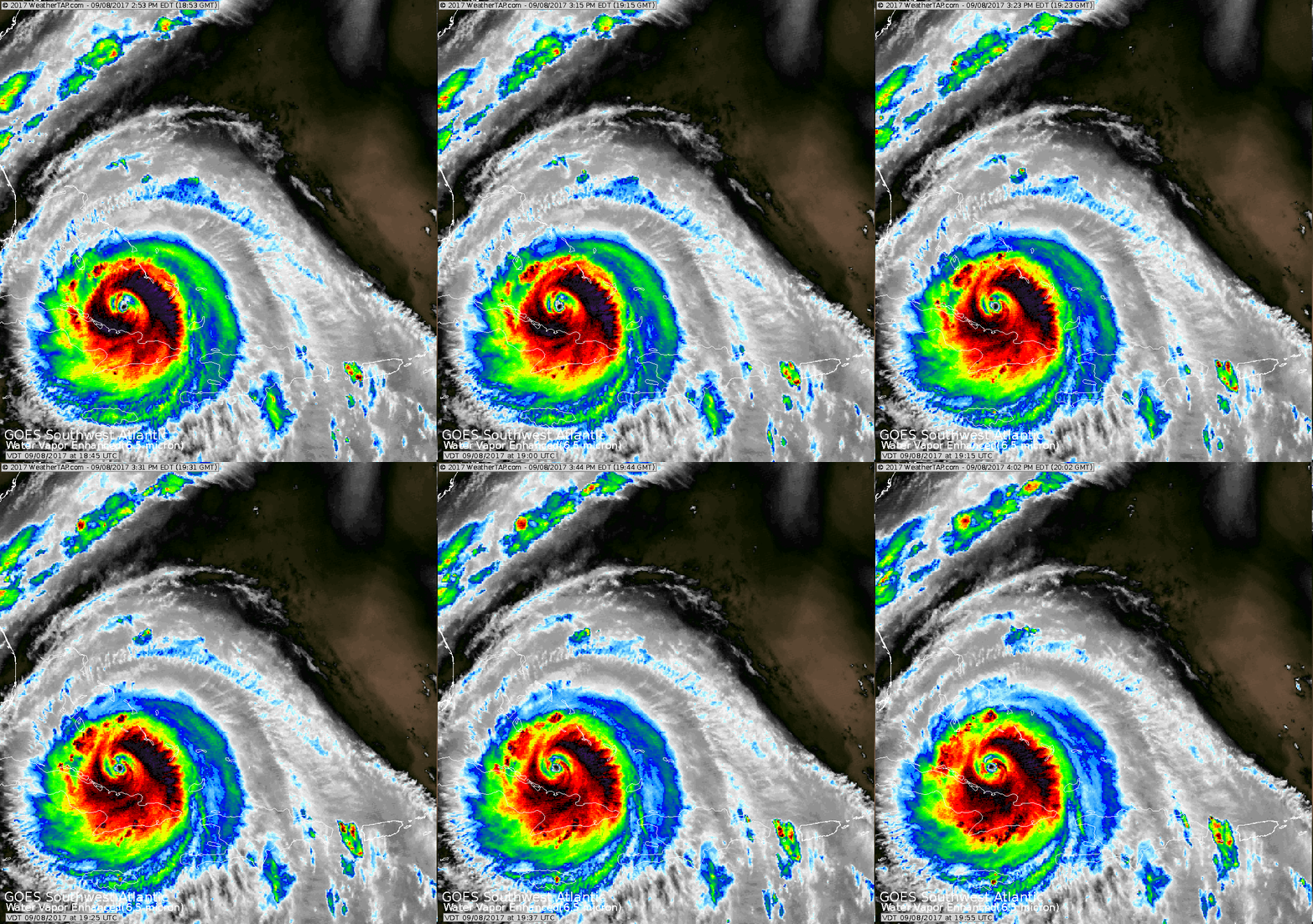
You see it on this graphic, north and west of the eye. “Yesterday’s pulse” is, I believe, out east of the eye, and closer in.
http://www.ssd.noaa.gov/PS/TROP/floaters/11L/imagery/20170908_1815Z-rbtop.gif
Maybe an odd question. How quickly after the hurricane passes would you expect roads heading back into Orlando to be packed with people returning? Do people rush back, or do they come back in a staggered fashion?
Also, if someone had a flight scheduled back to Orlando wednesday night, would you expect there to be difficulty with that, assuming no major damage to the airport?
Because the eye will be west of Miami, that puts the entire Miami metro area and areas south of it that was devastated by Andrew in 1992 under very serious threat, because the east side of a hurricane is usually the most intense and dangerous in terms of high winds and rainfall.
There are Americans stranded in St. Maarten, the Dutch side of the island. There is widespead looting and no security at the hotel where my relative was transported from an even smaller island. For unknown reasons, the US Government declined the offer of the Dutch military to evacuate Americans before Irma hit. Now Jose is barreling down on them. Please pray for him and all people in danger.
Errands to run. Skater momentum equations, converted to 3D inter-cranial animations, likely to impede list item capture.
I prayed for you.Please keep us updated.
Up thread, when I posted that some of my family is in Tampa Bay, you talked about your preparations.
My family has prepared their property the best they can and is ready to move to a nearby safe haven in an enclosed concrete elevated structure. We all appreciate your starting and maintaining this thread but please know that it will be okay if you are totally away from the thread as your needs require.
Right now, NOT on the NHC forecast but on the HMON model, the eye goes over Tampa after coming on shore at Marco Island. All of these models are nothing because with will have a major bend and Cuba glancing blow in the next 24 hours that is almost like a pool ball shot angle bouncing off a bumper. We may guess or model but we don’t scientifically know what the track is going to be tomorrow after the turn.
Please everyone, prepare no matter where you are in relation to this storm.
Very cool indeed but I hope he kept his eyes closed. :)
Yes but no wing dip response :-)
Whoever is responsible for that stupidity needs to be abandoned at sea. Prayers up for your relatives.
I’m a large-ish, cranky former Marine and I have had many of them, because I like cats a lot. I get them, they get me, we get along.
Prayers for all on St Martin/Maarten island.
Bastardi has posted that he will be on Hannity radio (1 interview in each hour), FBN at 5pm, and Hannity Show tonight. No doubt much that he says will be redundant, but 5pm and 10pm should include his updates, if any.
Agree that the best and most current info has been on this thread. So far, I’ve avoided TV (don’t live in any affected areas...yet).
Bastardi on Hannity radio:
“1935 Labor Day Hurricane...literally, the salt and wind and rain literally blasted clothes off people. That’s how strong that kind of wind is.”
“I don’t think people understand what this storm is capable of. We did some calculations here and we came up with this: We believe that the highest wind gusts in the Miami area Sun afternoon will be 100-120mph.
“When you are talking about Naples, Bonito Springs (sp?), Marco Island, it may go over 150 mph. Same thing in the Fla Keys.
“When you get up to Tampa, Orlando, Daytona Beach—that area—it looks like 100mph peak gusts probably coming Sunday night.
“Jacksonville—I’m bringing it up the coast—Monday morning, peak wind gusts 80-100mph.
“Atlanta and Savannah, Monday afternoon, peak wind gusts around 80mph.
“Charleston, 60mph Monday night.
” So, you have a timeline on when the worst of this will be moving up the coast.
“This storm is ferocious at its core where it hits. You’re going to see it move due west tonight; it may get into Cuba for awhile. When it comes out of Cuba and it starts making that turn...this system...will be intensifying coming into the Keys and Southwest Fla, so even though it’s a 4 right now...this system may indeed be up to a 5———
Sheesh...sorry...I lost my connection, but this is probably enough to get Bastardi’s meteorological point of view.
Another data point: Disney World is closing down for a few days. They are hoping to re-open tuesday morning. Giving full refunds for everybody impacted. They have a general policy that if there is a hurricane, you can get refunded for hotels and tickets.
My daughter has a long-scheduled trip to Disney starting with a tuesday morning drive, so we’ll see how that goes.
Just got a note from Jeff Piotrowski that says he will be covering Irma live from South Florida. Hope he stays safe. I had to stop watching the Harvey event...
Best practice is to follow local reports and to determine whether roads are passable all along your route. Then, you must know whether you have enough gasoline for a possible round trip back to where you sheltered if the damage makes a home uninhabitable.
Local Emergency Management Ops will have most of the neighborhood info.
If local damage is extreme, LEO will likely not allow anyone into the area until SAR has cleared the area. If local damage allows for return, have documents for proof of residence to the locattion, and be prepared for power out, water contaminated. Now--do you have enough fuel to get back to a location for shelter.

Disclaimer: Opinions posted on Free Republic are those of the individual posters and do not necessarily represent the opinion of Free Republic or its management. All materials posted herein are protected by copyright law and the exemption for fair use of copyrighted works.