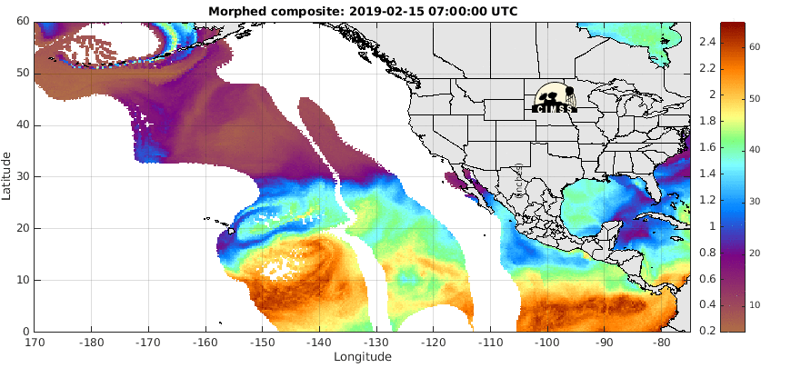
This illustrates the 'atmospheric river'. It's dissipated a bit, and is based on the low pressure system spinning counter-clockwise to the North, which is 'fetching' the river.
Posted on 02/12/2017 4:26:47 PM PST by janetjanet998
Edited on 02/12/2017 9:33:58 PM PST by Admin Moderator. [history]
The Oroville Dam is the highest in the nation.
“... auto-correct screws with me all the time ...”
-
You know you can turn that crap off, right?
OMG.
I’d post some atmosphere .gifs, but I don’t want to slow anyone down.
The same mistake darned-near took out Glen Canyon dam in 1983 (not a spillway, the entire dam).
I’ll take the Tailfeather please. It’s important to remain fashionable.
Post them!
So much for Moonbeam Brown’s, “Oh well, stuff happens...”
http://www.sacbee.com/news/weather/article133714379.html
“Two hours south in the San Joaquin Valley, locals nervously were watching the swollen San Joaquin River. The river at a critical measuring station near Vernalis southeast of Tracy had filled to “danger stage” Saturday night. That’s the point that emergency officials say water could over-top levees.
“We’re bracing for flooding,” said Jenny Rich, a spokeswoman for San Joaquin County. “We’re anticipating it happening.”
Low lying areas around the river, which passes by Manteca, Lathrop, Stockton and Tracy, are all are at risk. But Rich said most of the troubles are likely to occur in southern San Joaquin County.”
thank you :-)
The truth Must be CORRECTED!
I’m seeing the pictures and watching the feed
https://www.facebook.com/FoxNews/?hc_ref=NEWSFEED
It looks like the spillway is broken in two places now? That bottom section is going to be gone shortly.
This illustrates the 'atmospheric river'. It's dissipated a bit, and is based on the low pressure system spinning counter-clockwise to the North, which is 'fetching' the river.
1. Here is an Original "Artist Conception" of the Oroville dam. These renditions are done in consultation with engineers and was used to promote the project to the public. Notice the "wing shaped" Main Spillway design. Also notice that the spillway was irregular going down the mountain as if it were cutting into natural rock (could have been a "liberty" of the artist).

2. There are indications that initial construction & grading of the "saddle" spillway area had the option of implementing a "wing shaped" Main Spillway (denoted in red shading in this Google Earth view). Also, test drill locations tend to support the thinking of a "wing shape" option.

3. Special 1:78 and 1:42 scale working models were built and carefully tested in a lab environment. The scale models show it became obvious that ideal "laminar flow" was the design of choice. This meant that the additional "wing" portion would have been too turbulent at a focus region in the spillway chute.


4. If the initial grading was performed to facilitate a "winged" section, but not ultimately used, then the Emergency Spillway Wier would need to account for the grade differential - thus the higher section near the Main Spillway Gate Structure area. These effects resulted in a focused wash basin topology that ultimately initiated the extreme gash erosion from the overspill flow.

5. Engineers were wise to have concerns about this focused wash basin. They "armored" the side area berm of the access road (see where concrete boom truck is covering a layer of placed rock in the image). They did this work before the storm overtopped the spillway. Also notice that they did some moderate grading of the hillside & removed vegetation - in an attempt to maintain a laminar flow (light emphasis on "attempt" & "laminar flow").

Same thing, just in Water Vapor white and blues. You can't pick out the actual spinning lows with the cloud deck.

Forecast thru the 22nd.
I use a feather touch hitting post, but I've been double-posting so much lately I'm afraid to gunk up the thread with duplicate .gifs.
Well, it happened AFTER Trump got elected so by default, it's his fault.
I like the included multiple comets in the artist’s ‘conception’. :0
DOOM ON.... no wait... these are reflections...
Comets.... maybe the artist knew the future... :-)
Disclaimer: Opinions posted on Free Republic are those of the individual posters and do not necessarily represent the opinion of Free Republic or its management. All materials posted herein are protected by copyright law and the exemption for fair use of copyrighted works.