The turbulence might be caused by water flowing over the retaining wall near the gate.
There is a small berm or ledge atop part of the retaining wall and appears to be what is sticking out of the water in the circled area of the photo in #1320
Posted on 02/12/2017 4:26:47 PM PST by janetjanet998
Edited on 02/12/2017 9:33:58 PM PST by Admin Moderator. [history]
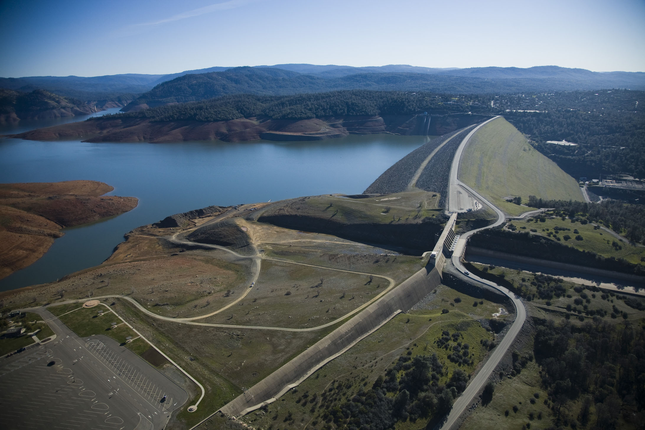
The Oroville Dam is the highest in the nation.
>>Just curious what you actually did to come to your confident conclusion.<<
To do any accurate analysis you need a very high resolution system DPI & high color true 32 bit per pixel resolution (and a very large display).
This is very clear on my system. There are may high resolution image analysis controls to identify any slight influences that could result in an artificial change. Thus, using precision sliding “real time display control” of exposure, contrast, saturation, temperature, tint, sepia, and sharpness, you see if there are any combinations that can cross match ALL of the colors in each image to transition it to a copy of the other.
There is a “real time spectral display” in the software to also reveal the composite high resolution result. IN all cases of testing, there was no “cross match” combinational condition. So the only way this could be artificial is if the original camera system had a non-linear response to only certain areas of the CCD bias & color translation. This is equivalent to saying precise areas of the camera CCD hi-def pixel array equally altered itself in perfect alignment to the flow of the water (sections) - but left the rest of the hi-def pixel array unaltered.
Highly unlikely.
The turbulence might be caused by water flowing over the retaining wall near the gate.
There is a small berm or ledge atop part of the retaining wall and appears to be what is sticking out of the water in the circled area of the photo in #1320
Great picture, thanks.
It gives a perspective that I had not seen before.
>>Would be nice to know the times of capture as well... if this was while they were reducing the flow rate, would not the flow velocity come down a bit as well?<<
Between the two images, the plume volume, shape, outline, and “marker” flow around the rocks indicate a concise match in a volume flow. With a concise match in volume flow, the only way to get a sudden coloration change is through an injection of a material (such as soil).
The best answer to this question likely will be revealed as a possible landslide. The increased waterflow on the left side of the spillway is coming from the blowout area upstream. This left side blowout area is near the electrical transmission tower(s). There are images of landslide erosion on that hillside that is likely going to threaten the closer tower. My best estimate would be that is the place to look for in a before/after hillside comparison.
Bookmark
Dam design construction blueprints show this incoming waterflow channel as the "approach channel". The far side wall of this waterway "approach channel" is the "Cut escarpment".
This enlarged image shows trees growing in the berm/embankment that what looks like a concrete wall that joins to the upside down "J" of the curved "approach wall" inlet.
What is of note is that the composition of this apron, with trees growing in a "soil or aggregate/soil" base is not a protected surface if turbulence were to occur (notice the grooving in the berm from equipment).
This turbulence, brown discoloration in other images, and the soil/aggregate design of this inlet has been the source of heated discussions in whether there is a risk of an "erosion scouring" at the entrance to the Main Spillway inlet (approach wall). This would be a serious condition.
Of course, the huge "bubbles" that were caught by the Fox10 helicopter crew overflight in front of the Emergency Spillway weir suggests that there is a porosity potential via the soil -in front of - and the now known layer of "fractured rock" that the ES rests upon.
The approach channel likely has this same substructure. Laminar flow is very important to prevent scouring with any non-armored surfaces.

Right, they can’t open the power station water gates.
KC Burke, earthresearcher,
what is that dark rectangle ? Some large piece of concrete slab?
I saw the pics and explanation, so its not a big slab of concrete....?
I guess what y’all are saying is that something could block the main spillway and thus all the water would go over the weir?
>>what is that dark rectangle ?<<
That is a good question. The two trees in post image 1,320 align with the trees in post image 1,346 - which aligns with the left image side edge of the “dark rectangle”. Why it is so dark is a good question. What is also of note is that the curved “J” part of the “approach wall” doesn’t really show itself in the turbulent profile in post image 1,320.
When/if things dry out and the inlet water levels are lower may clues be answered. (The coloration of the top of the wetted far concrete wall on the main spillway has a similar color). Just not enough information to answer well.
It’s difficult to tell from the photo but it looks like the approach wall ends near where the berm’s equipment scarring begins. I think it’s not an earthen berm but a rocky ledge, a piece of the escarpment the channel cuts through. From the end of the approach wall the ledge decreases in height above the channel floor in the upstream direction, and toward the gate it rises above the wall then abruptly ends at the “J” wall. In the photo water is flowing around all but the highest parts of the ledge. Due to the way the escarpment hooks around in front of the approach channel water enters the channel at an angle, some of the water entering directly toward the gate and some flowing over the submerged rising ledge and entering the channel nearly perpendicular to the main flow. Both the ledge and the confluence of the flows causes turbulence. I agree it might be causing some scouring, particularly since the approach channel floor appears to be aggregate.
I’ve read several comments about bubbles but haven’t seen any photos.
I’ve been thinking about the rock bags dumped in the holes at the far corner of the parking lot. Where did that water go? There appears to be a seasonal, or perhaps now defunct due to the dam, stream about 2000 feet away. Perhaps there is a seam the water followed. A few days ago there was a small earthquake about 200 feet underground where the stream joins the river. It’s marked on this map https://www.google.com/maps/place/39%C2%B032’31.4%22N+121%C2%B030’35.4%22W/@39.5432017,-121.5071578,1356m/data=!3m1!1e3!4m5!3m4!1s0x0:0x0!8m2!3d39.54206!4d-121.50984 I mention this because it supports the “rotten rock” concerns.
There’s usually scouring on the downstream side of boulders. The ledge and wall are in essence boulders. I would be surprised is there was not some scouring at the base of the ledge.
That is a massive dam...reassuring ...The Spillway migt go ouy buy yhjr fsm eill dutvivr.Downstream stuff will get damaged of course.
Whoops forgot to spell check.
That is a massive dam...reassuring ...
The Spillway might go out but the dam Will survive .
Downstream stuff will get damaged of course.
I douby any official will admit to such a thing...
Here is an image that shows soil erosion colored brown waterflow on the left while the main spillway is white (not brown). Contrast this with the image(s) in post 1,326. The "browning" is from sediment material via erosion entering into a waterflow. The waterflow on the outside edge of the sidewall is white at the time of this photo.

But it makes sense...
In this pre-failure stage of the Main Spillway, brown water signaled the undermining of the concrete slabs in the main spillway. Notice the tremendous side flow of brown water on the outside edge of the containment wall.
The importance of this image is that "brown water" in the main flow could indicate a source in the main spillway that injected a burst of substrate material. However, the more likely case is an injection of material at/near the main spillway blowout.

Disclaimer: Opinions posted on Free Republic are those of the individual posters and do not necessarily represent the opinion of Free Republic or its management. All materials posted herein are protected by copyright law and the exemption for fair use of copyrighted works.