Posted on 02/28/2009 7:29:54 AM PST by ETL
US Strategic Command is still cataloguing debris from the Feb. 10th satellite collision over northern Siberia. "The count is now at 109 catalogued fragments for Iridium 33 and 245 for Kosmos 2251," says satellite observer Daniel Deak, who has prepared some 3D maps of the debris for readers of spaceweather.com. Click on the image to view a snapshot of Kosmos fragments on Feb 26th: (see the provided spaceweather.com link)
A similar image shows Iridium 33 debris, and other views are available, too: #1, #2, #3, #4, #5. (see the provided spaceweather.com link)
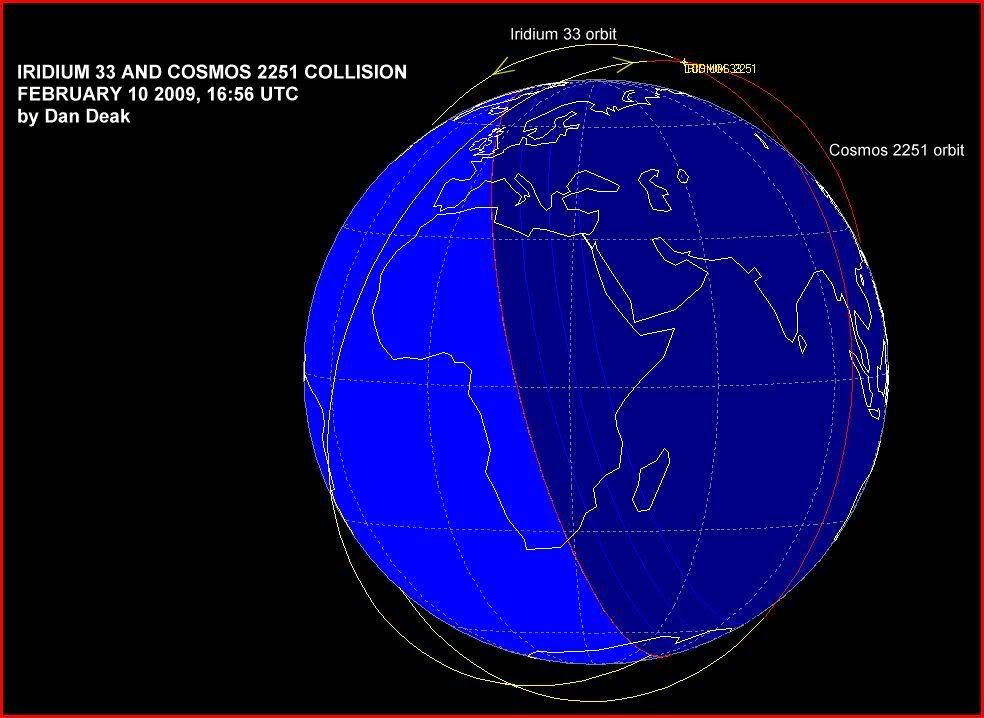
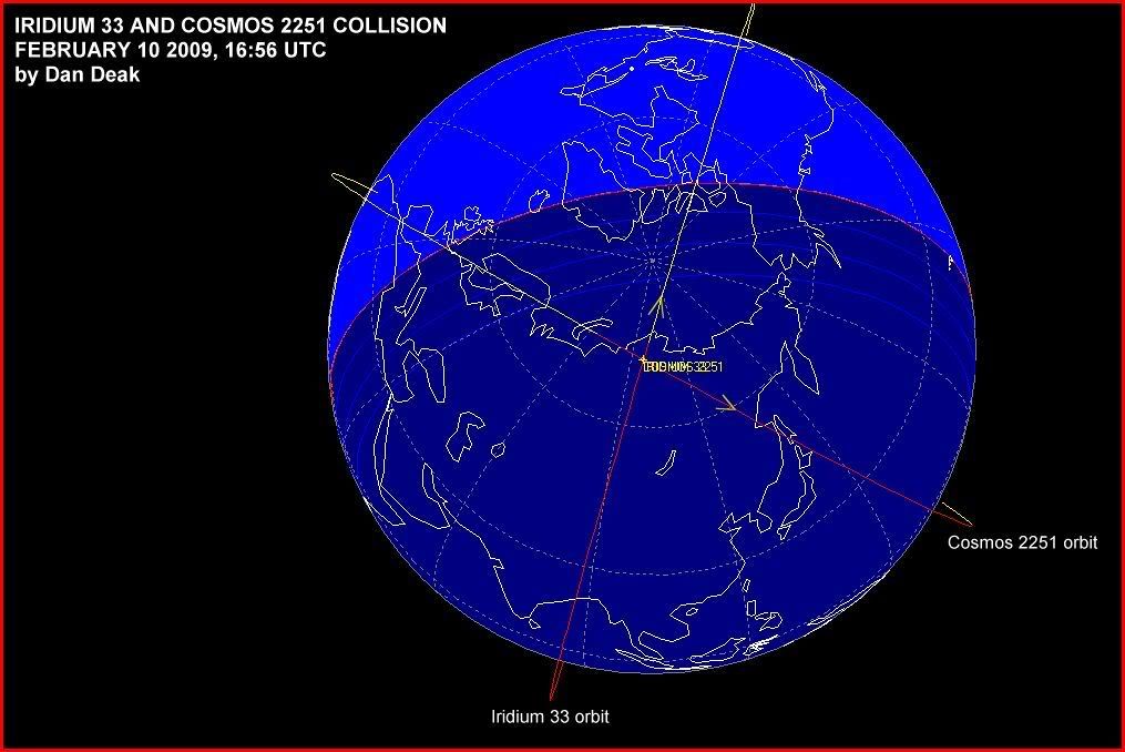
These maps reveal in full what earlier, less complete maps strongly hinted: Kosmos debris is scattered more widely than Iridium. "Kosmos fragments range in altitude from 250 km to 1690 km," says Deak. For comparison, "Iridium fragments range only from 525 km to 1092 km." Kosmos fragments descend all the way down to the 350 km orbit of the ISS. The space station is in little danger, however; most of the Kosmos scatter is over the Antarctic where the ISS does not go.
The fragment count now stands at 354. Says Deak, "there are surely more to come."
**FEB 28th UPDATE: Since these maps were posted on Feb. 26th, the catalogued fragment count has jumped from 354 to 414. Stay tuned for updated maps.
Source: spaceweather.com for Saturday, Feb 28, 2009: http://www.spaceweather.com/
I still say that only a fool would completely discount intent in this case. There’s a heck of a lot of technology we don’t know about. And Iridium IS a military system.
“The Iridium satellites are relatively small telecommunications satellites in a low Earth orbit. They are part of a world-wide system for mobile communications operated by the Iridium LLC Corporation. When complete, there will be a total of 66 satellites in 6 orbit planes, at an altitude of around 780km.
As can be seen from the diagram opposite, each satellite has three main mission antennas (MMAs), which are flat, highly reflective surfaces, that can reflect the Sun’s rays to an observer on the ground when the geometry is correct. The satellite’s attitude is controlled so that the long axis remains vertical, with one MMA always pointing forwards. Given this knowledge of the attitude, together with the orbital position of the satellite and the Sun and observer’s location, it is possible to calculate the angle between the direction to the observer from the satellite and the line of a perfect reflection of the Sun. This is the so-called “mirror angle” and determines the magnitude of the flare.
An Iridium Flare The photo on the right of two Iridium flares was taken by Porter Kier on January 11th, 1999. It shows Iridiums 20A (Mag. -2) and 22 (Mag. -7) above the Chesapeake Bay, Virginia area. For more information on the photo, and a full size version, just click on the image.”
http://heavens-above.com/iridiumhelp.asp
/mark for later
More info from the Iridium company’s website:
Company Profile
Based in Bethesda, Maryland, U.S.A., Iridium Satellite LLC, a privately held company, is the only provider of truly global satellite voice and data communications solutions with complete coverage of the entire Earth including oceans, airways and even Polar Regions. Iridium delivers reliable, secure, real-time, mission-critical communications services to and from areas where landlines and terrestrial-based wireless services are either unavailable or unreliable.
Iridium’s constellation consists of 66 low-earth orbiting (LEO), cross-linked satellites operating as a fully meshed network and supported by multiple in-orbit spares. It is the largest commercial satellite constellation in the world.
The Iridium service is ideally suited for industries such as maritime, aviation, government/military, emergency/humanitarian services, mining, forestry, oil and gas, heavy equipment, transportation and utilities. For example, tens of thousands of aircraft are currently equipped with Iridium-based systems and nearly half of the traffic on the Iridium network comes from international waters. Iridium provides service to subscribers from the U.S. Department of Defense (DoD), as well as other civil and government agencies around the world. The company also designs, builds and sells its products, solutions and services through a worldwide network of hundreds of partners.
Iridium manages several operations centers including those in Tempe, Arizona and Leesburg, Virginia, U.S.A. In addition, through its own gateway in Hawaii, the U.S. DoD relies on Iridium for global communications capabilities.
The company supplies both voice and data connections. Voice services are provided via dedicated handsets, or through a variety of installed communications systems onboard ships, aircraft and land-based vehicles. Increasingly incorporated into hundreds of applications, Iridium’s 9601 short burst data (SBD) transceiver provides packet data connections to every corner of the Earth, transferring location information, weather reports, email, or any other data requiring a reliable, global, two-way connection. Iridium’s most rapidly expanding business segment is the machine-to-machine sector, in which the Iridium constellation provides mobile data links for asset tracking and other monitoring applications.
Iridium is a profitable company and has been since 2004. Business is growing at an impressive rate with the constant acquisition of new customers and partners both domestically and abroad in some of the furthest reaches of the planet. These individuals recognize the value of a system that is global, secure and guaranteed to work.
Iridium is also planning for the future sustainability of its constellation, making major investments in network enhancements and launching the Iridium NEXT initiative, its next generation satellite constellation, which will be fully operational by 2016.
http://www.iridium.com/about/about.php
Thanks for the Photos!
Take that, Russkies. Our satellite won.
“As can be seen from the diagram opposite, each satellite has three main mission antennas (MMAs), which are flat, highly reflective surfaces, that can reflect the Sun’s rays to an observer on the ground when the geometry is correct. The satellite’s attitude is controlled so that the long axis remains vertical, with one MMA always pointing forwards. Given this knowledge of the attitude, together with the orbital position of the satellite and the Sun and observer’s location, it is possible to calculate the angle between the direction to the observer from the satellite and the line of a perfect reflection of the Sun. This is the so-called “mirror angle” and determines the magnitude of the flare.”
Catch a *Flaring/Glinting Iridium:
http://www.satobs.org/iridium.html
For a visible Iridium Flare pass schedule for your area, see:
http://heavens-above.com/
ping
I thought they were launched by Motorola to provide satellite phone service.
They are private, but the vast majority of their business is military.
>>>Take that, Russkies. Our satellite won.
Our satellite was apparently lost by gross negligence. That’s no win. Absent additional information, this was an historic screwup.
The Russian satellite was in a parking orbit. Unless we receive information it corrected its orbit and intercepted the Comsat, which we have not, then it appears the Iridium program managers failed to keep track of the obstacles that menaced their bird and correct their own orbit accordingly.
To put it in simpler terms, a charted abandoned floating barge and a powered boat with a helmsman collide. Who gets their papers pulled by the Coast Guard.
yeah but most of the service is used by the military
It's not about the papers, it's about the fireworks beforehand.
I'm having some trouble wrapping my brain around the proposition that most of the Kosmos scatter is over the Antarctic where the ISS does not go. What am I missing about this?
The pieces that used to be Kosmos were in orbit before the collision and will continue to be in orbit afterwards (albeit in different orbits than the original one). Perhaps the inclination of the orbit(s) is polar, which would account for the "over the Antarctic" remark, however the stuff is not just going to sit there in a mass over the Antarctic - rather, it will still zip up towards the equator and beyond, up to the north polar region, before returning to the south. And it will repeat that path, possibly every couple hours or so, give or take a bit, depending on the actual orbital altitude. So conceivably the path of some of the debris could intersect with the orbit of the space station (which has a much lower inclination).
Maybe the Kosmos debris orbits are highly elliptical, with apogee over the southern pole, so that the portion of the orbit where the debris is at the same altitude as the space station only occurs at high northern latitudes that the space station never reaches. Conceivably it could be in such an elliptical orbit that most of the orbital period would occur over the lower Southern Hemisphere, and the portion of the orbit when the debris finally whips up to and around the northern polar region is relatively short. However the claimed maximum/minimum altitudes of 250 km to 1690 km do not appear to indicate extreme ellipticity (if you take that to be the characterization of a single orbital parameter - I suppose that it could also be interpreted to mean that the debris orbits are roughly circular, but that the debris ended up in lots of different orbits at lots of different altitudes rather than a dense mass of debris all with roughly the same elliptical orbit - however I am not a rocket scientist, so what do I know). Otherwise, I don't see how that statement makes sense...
Sorry, don’t have time at the moment to really think about your question. Perhaps these links might help...
ISS orbital data:
http://heavens-above.com/orbit.aspx?satid=25544&lat=0&lng=0&loc=Unspecified&alt=0&tz=CET
(former) Cosmos 2251 orbital data:
http://heavens-above.com/orbit.aspx?satid=22675&lat=0&lng=0&loc=Unspecified&alt=0&tz=CET
(former) Iridium 33 orbital data:
http://heavens-above.com/orbit.aspx?satid=24946&lat=0&lng=0&loc=Unspecified&alt=0&tz=CET
Thanks... Evidently the pre-collision Cosmos 2251 orbit was nearly circular. It did have a fairly high inclination. How that would translate into likely debris field orbital parameters is beyond my knowledge of physics, however...
/
Disclaimer: Opinions posted on Free Republic are those of the individual posters and do not necessarily represent the opinion of Free Republic or its management. All materials posted herein are protected by copyright law and the exemption for fair use of copyrighted works.