Posted on 08/30/2008 3:25:36 AM PDT by HAL9000
Thanks
no kidding
i worked in Beaumont in 80 and would drive home to Jackson Miss frequently and on Friday afternoons I-10 was awful
like bumper to bumper from Houston to Baton Rouge and Hammond
I-40 in TN is like that now
you have probably been deluged with private freepmails by all the scalawag men on this forum now...;>)
/s
the plane just found flight level winds of 165MPH
so the surface winds are likley 140 MPH which would make this is CAT 4
pressure 944 mb
May weaken somewhat over Cuba, but check out the water temps for the Gulf as of right now, it seems to be baking...
http://www.weather.com/maps/geography/oceans/gulfcaribbeanseasurfacetemps_large.html
Good point. Better stock up now because Mason Williams was wrong - there ARE empty Tabasco Sauce bottles.
DATA FROM AN AIR FORCE RECONNAISSANCE AIRCRAFT INDICATE THAT
GUSTAV HAS CONTINUED TO STRENGTHEN AND NOW HAS MAXIMUM WINDS
NEAR 145 MPH...230 KM/HR WITH HIGHER GUSTS.  THIS MAKES GUSTAV AN
EXTREMELY DANGEROUS CATEGORY FOUR HURRICANE ON THE SAFFIR-SIMPSON
HURRICANE SCALE.  A SPECIAL ADVISORY WILL BE ISSUED AT ABOUT 200 PM
EDT TO MODIFY THE INITIAL AND FORECAST INTENSITIES.  THE SPECIAL
PUBLIC ADVISORY WILL TAKE THE PLACE OF THE INTERMEDIATE PUBLIC
ADVISORY PREVIOUSLY SCHEDULED FOR THAT TIME.
WTNT62 KNHC 301718
TCUAT2
HURRICANE GUSTAV TROPICAL CYCLONE UPDATE
NWS TPC/NATIONAL HURRICANE CENTER MIAMI FL AL072008
120 PM EDT SAT AUG 30 2008
Data from an air force reconnaissance aircraft indicate that
gustav has continued to strengthen and now has maximum winds
near 145 mph...230 km/hr with higher gusts. This makes Gustav an
extremely dangerous CATEGORY FOUR Hurricane on the Saffir-Simpson
hurricane scale. A special advisory will be issued at about 200 PM
EDT to modify the initial and forecast intensities. The special
public advisory will take the place of the intermediate public
advisory previously scheduled for that time.
$$
Forecaster Knabb
One of the more important models (The UKMET) just shifted drastically east, from no landfall at all and curving SW near Texas, to a landfall in Southeast Louisiana.
The stupid thing about that is that the Superdome was a fine place to keep people. Only one or two people died there, and they may have died anyway from natural causes.
Nobody starved, everybody was clothed and fed, and they all survived a really bad hurricane.
They did much better than those who foolishly decided to stay in their homes 20 feet below sea level in a town surrounded by water held back by big walls.
A Cat 2 would be a strong storm, but Katrina was much stronger. La can handle a Cat 2 storm. There also won’t be the same storm surge as Katrina, which was a cat 5 at one point pushing the water to the coast.
Both Katrina and Rita hit as Cat 3s.

Quote
“A Cat 2 would be a strong storm, but Katrina was much stronger. La can handle a Cat 2 storm. There also won’t be the same storm surge as Katrina, which was a cat 5 at one point pushing the water to the coast.”
Ummm no. Not hardly. Katrina was no where near a 5 when she hit the land. You are 100% incorrect on this statement.
A cat 2 hitting New Orleans would indeed be a disaster. If this system is a Cat 3/4/5 across the GOM then the storm surge damage will be done, regardless of what it is at landfall.
This is a very bad situation. Don’t downplay it.

Now CAT 4 Storm with prediction it will be CAT 5 storm.
NHC/NOAA 2 PM DISCUSSION:
000
WTNT42 KNHC 301823
TCDAT2
HURRICANE GUSTAV SPECIAL DISCUSSION NUMBER 24
NWS TPC/NATIONAL HURRICANE CENTER MIAMI FL AL072008
200 PM EDT SAT AUG 30 2008
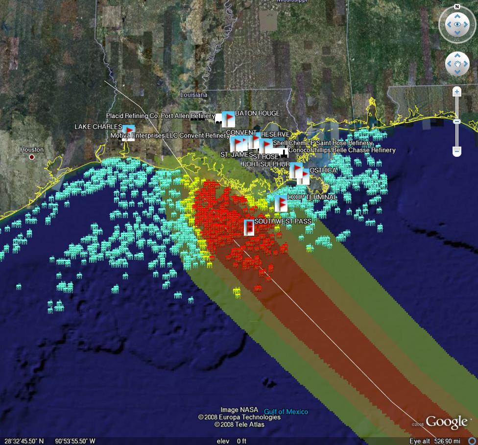
SO MUCH FOR A SLOWDOWN IN THE INTENSIFICATION RATE OF GUSTAV. YESTERDAY AT THIS TIME WE CONVEYED THAT RAPID INTENSIFICATION OVER THE NORTHWESTERN CARIBBEAN WAS POSSIBLE...BUT THIS IS A LITTLE MORE THAN WHAT WE HAD IN MIND IN SUCH A SHORT TIME. THE HURRICANE HAS REACHED CATEGORY FOUR STATUS WITH AN INTENSITY OF 125 KT...HAVING BEEN A STRONG TROPICAL STORM JUST ABOUT 24 HOURS AGO. THE MAXIMUM SURFACE WIND VALUE IS BASED ON A FLIGHT-LEVEL WIND AT 700 MB OF 141 KT...SINCE THE 90 PERCENT ADJUSTMENT TO THE SURFACE USUALLY WORKS RATHER WELL FOR INTENSIFYING MAJOR HURRICANES. THE AIRCRAFT FIXES INDICATE THAT A NORTHWESTWARD MOTION HAS RESUMED...AND THE INITIAL MOTION ESTIMATE IS 315/12...RIGHT ALONG THE PREVIOUS ADVISORY TRACK. NO CHANGES TO THE 1500 UTC FORECAST TRACK HAVE BEEN MADE...BUT THE INTENSITY FORECAST HAS BEEN ADJUSTED UPWARD THROUGH 96 HOURS. GUSTAV COULD INTENSIFY SOME MORE DURING THE NEXT FEW HOURS OVER WATER...AND ONE CANNOT RULE OUT CATEGORY FIVE INTENSITY BEFORE CROSSING CUBA. THE FORECAST NOW CALLS FOR A PEAK AT 140 KT...CATEGORY FIVE INTENSITY...OVER THE SOUTHERN GULF WHERE OCEAN HEAT CONTENT WILL STILL BE HIGH...FOLLOWED BY A VERY GRADUAL WEAKENING OVER THE NORTHERN GULF WHERE OCEAN HEAT CONTENT IS LESS.
FORECAST POSITIONS AND MAX WINDS
INITIAL 30/1800Z 21.6N 82.5W 125 KT
12HR VT 31/0000Z 22.5N 83.5W 135 KT...OVER WESTERN CUBA
24HR VT 31/1200Z 24.3N 85.4W 140 KT
36HR VT 01/0000Z 26.0N 87.3W 135 KT
48HR VT 01/1200Z 27.8N 89.2W 125 KT
72HR VT 02/1200Z 30.5N 92.5W 80 KT...INLAND
96HR VT 03/1200Z 31.5N 94.0W 50 KT...INLAND
120HR VT 04/1200Z 32.0N 95.5W 30 KT...INLAND
$$
FORECASTER KNABB
Be advised storm is updgraded to CAT 4 and is expected to reach CAT 5 strength -- per National Hurricane Center forecast special alert 2pm EDT.
Maybe title can be changed since it is in BREAKING NEWS Category...
Never seen this before. Cool.
LOL!!!
Disclaimer: Opinions posted on Free Republic are those of the individual posters and do not necessarily represent the opinion of Free Republic or its management. All materials posted herein are protected by copyright law and the exemption for fair use of copyrighted works.