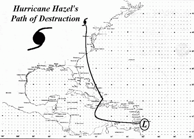
Check the loony track it made.

Posted on 09/12/2006 7:42:58 AM PDT by SoFloFreeper
ZCZC MIATCPAT3 ALL TTAA00 KNHC DDHHMM BULLETIN TROPICAL DEPRESSION EIGHT ADVISORY NUMBER 1 NWS TPC/NATIONAL HURRICANE CENTER MIAMI FL AL082006 1100 AM EDT TUE SEP 12 2006
...EIGHTH TROPICAL DEPRESSION OF THE SEASON FORMS OVER THE FAR EASTERN TROPICAL ATLANTIC...
SHIP REPORTS AND SATELLITE IMAGES INDICATE THAT A TROPICAL DEPRESSION HAS FORMED FROM THE TROPICAL WAVE THAT MOVED OFF THE WEST COAST OF AFRICA YESTERDAY.
AT 1100 AM EDT...1500Z...THE CENTER OF TROPICAL DEPRESSION EIGHT WAS LOCATED NEAR LATITUDE 12.5 NORTH...LONGITUDE 23.0 WEST OR ABOUT 185 MILES...295 KM...SOUTH-SOUTHEAST OF THE SOUTHERNMOST CAPE VERDE ISLANDS.
THE DEPRESSION IS MOVING TOWARD THE WEST NEAR 18 MPH AND THIS GENERAL MOTION IS EXPECTED TO CONTINUE FOR THE NEXT 24 HOURS.
MAXIMUM SUSTAINED WINDS ARE NEAR 30 MPH...45 KM/HR...WITH HIGHER GUSTS. SOME STRENGTHENING IS FORECAST DURING THE NEXT 24 HOURS...AND THE DEPRESSION COULD BECOME A TROPICAL STORM WITHIN THE NEXT DAY OR SO.
ESTIMATED MINIMUM CENTRAL PRESSURE IS 1007 MB...29.74 INCHES.
REPEATING THE 1100 AM EDT POSITION...12.5 N...23.0 W. MOVEMENT TOWARD...WEST NEAR 18 MPH. MAXIMUM SUSTAINED WINDS...30 MPH. MINIMUM CENTRAL PRESSURE...1007 MB.
THE NEXT ADVISORY WILL BE ISSUED BY THE NATIONAL HURRICANE CENTER AT 500 PM EDT.
$$ FORECASTER PASCH
I guess New Orleans got all the press (still getting it, for that matter), but it's true that other areas were much harder hit in terms of storm intensity.
I'm going to go out on a limb here and call 'Fish' on this one too...
Check the loony track it made.

Please oh please can't we just get s little death and destruction from one of these? All we ask is for a city to be destroyed, just a small city, preferably in the South.
Last year my DH and I were on a cruise in the Eastern Caribbean with Rita, then we were on a cruise in the Western Caribbean with Wilma, sailing out of Galveston. Next week we will be cruising to Bermuda with Gordon. We sure know how to pick vacations.
Isn't that the map from last year?
In the short term, there is a lot of dry air around it, and that has been the bane of intensification all season.
Looks like my vessel, will stay on the hard for another week. Had it hauled out and blocked for Florence. Ready to go now, but the seas are 6-9 ft for the ride back to the marina, exiting St. Lucie Inlet and entering Ft. Pierce. A tad too much for me....
As of this hour, the only model runs I've been able to find are the extremely simplistic ones, pretty much based on the historical tracks. Their "guidance" shows nearly what you see on post#14, and as well as I understand it, are based on precisely that data. The SHIPS intensity model (which has been spectacularly incorrect this year) is the only more "modern" model that has been run so far, has it running up to Cat.1 in 2 days, and Cat.3 in 4 days... so it's looking like it wants to be "historical", too.
Looks like the NHC has backed off hyping the expected intensity from that "favored" model, though, possibly based on the earlier failures this year.
I hate it when you think you are out of trouble, then they turn right for you. 2 hits by the same storm is a new one on me, though.
St. Lucie Inlet has long had a reputation for being tricky and dangerous under certain conditions. Don't know about the one at Ft. Pierce.
What scared plenty of people on Guam was when Pamela II came through in the mid 80s. There wasn't much damage but the Joint Typhoon Warning Center decided to retire any name of a deadly or damaging storm because of the alarm the name caused. I think the National Hurricane Center followed suit, so you may never see a Hurricane named Katrina ever again.
![]()
That's a fair amount of movement to the north. Hopefully this will be another recurve.
Statement as of 5:00 PM EDT on September 12, 2006
Satellite images show that the depression is gradually becoming more organized with fairly prominent banding features over the western and southern portions of the circulation. However the center is still rather broad and elongated...and the area of convection to the west of the center is moving westward and becoming more separated from the center of the cyclone. A ship report from a vessel with call sign ovzv2 of northerly winds of 36 kt and a pressure of 1008.7 mb some 180 N mi northwest of the estimated center of the tropical cyclone. This wind observation was in convection...probably a localized squall...and not representative of the strength of the circulation. Moreover...a quality control check of this ship by the ocean prediction center indicated that its wind measurements were a few knots too high and its pressure has been running 1-2 mb low. Having said all that...the system is nearing tropical storm status and will probably be named tonight or on Wednesday. Modest easterly shear currently prevails over the area...and since the sea surface temperatures are fairly warm... strengthening seems likely in the short term. Global models differ in the details of the evolution of an upper-level trough near 40-45w north of 15n...but in general they suggest that it will become less influential in several days. The SHIPS model...using the GFS forecast fields as input...shows weak shear through the forecast period. I am not totally confident that the upper-level environment will remain so favorable...so the official intensity forecast is more conservative than the SHIPS output and just slightly below the consensus of the guidance.
A slight southward relocation of the center has been done for this package...consistent with microwave imagery...and the forward speed has been adjusted to be a little slower. Current motion is estimated to be 270/13. Dynamical guidance indicates an increase in forward speed over the next couple of days...suggesting a strengthening of the mid-level ridge to the north of the cyclone. By day 3 however...the guidance indicates that the system will respond to a weakness in the ridge near or just west of 50w...and begin to turn toward the right. The latest GFS...U.K. Met office...NOGAPS...and ECMWF global models are in better agreement on the track at days 4 and 5. The official track forecast has been shifted southward from the previous one for the first couple of days but is adjusted a little to the north in the latter part of the forecast period. This is near the left edge of the track guidance envelope.
Forecast positions and Max winds
initial 12/2100z 12.0n 23.9w 30 kt
12hr VT 13/0600z 12.0n 26.3w 40 kt
24hr VT 13/1800z 12.3n 29.5w 45 kt
36hr VT 14/0600z 12.6n 33.1w 50 kt
48hr VT 14/1800z 13.3n 36.7w 60 kt
72hr VT 15/1800z 15.5n 42.0w 70 kt
96hr VT 16/1800z 17.5n 46.0w 85 kt
120hr VT 17/1800z 20.0n 50.0w 95 kt
$$
forecaster Pasch
Weather guy in Houston says this one will follow Florence and Gordan...most likely.
I would agree at this point, but it is a long, long ways out and a lot can happen. But since it's a long, long, long ways out, no point worrying too much about it for at least a week or so.
It's about 10 days out, so it's definitely time to worry about it in 5 days, unless it's begun the recurve and no models show a ridge forming to keep it moving west.
This one came off fairly high off the African coast and that almost guarantees that it won't get into the Gulf. Worst case scenario is an eastern seaboard storm, although it looks TONIGHT as if it probably won't be a threat to land at all.
Models are notoriously wrong five days out. 10 days out they probably approach random ability. What I think is a pretty good bet is that we'll have Hurricane Helene later this week. And there's stuff lined up behind her.
Thread title needs to be changed to TS Helene. Thanks.
Disclaimer: Opinions posted on Free Republic are those of the individual posters and do not necessarily represent the opinion of Free Republic or its management. All materials posted herein are protected by copyright law and the exemption for fair use of copyrighted works.