To: abb; abbi_normal_2; aberaussie; Alas Babylon!; Alia; Alice in Wonderland; alnick; Amelia; asp1; ...
Florida Freepers: The Storm track has shifted again... A Tropical Storm Warning is being issued for Florida from Vero Beach southward on the East Coast...from south of Chokoloskee southward on the West Coast...for Lake Okeechobee...and for all of the Florida Keys from Ocean Reef to the Dry Tortugas. These areas also remain under a Hurricane Watch.

On/Off Hurricane Ping list, mash --->  .
.
268 posted on
08/28/2006 1:51:38 PM PDT by
NautiNurse
(Leroy Collins and Bill Nelson are both pro-abortion rights candidates)
To: NautiNurse
We have a tropical storm warning superimposed on a hurricane watch.
Looks like Toronto could get a rainy tag end of it in a fortnight or so.
273 posted on
08/28/2006 1:55:23 PM PDT by
Clive
To: NautiNurse; dirtboy
Tropical Storm Ernesto Discussion Number 17
Statement as of 5:00 PM EDT on August 28, 2006
The center is not well defined on high-resolution visible images and
synoptic surface observations from Cuba show little evidence of a
center. But based on observations from an Air Force hurricane
hunter aircraft flying along the north coast of Cuba...the center
is just inland of the north coast. The system became quite
disorganized... with most of the deep convection left behind near
the eastern tip of Cuba. Some of this disorganization may be due
to the influence of a small upper low just to the north-northwest
of Ernesto. Recently...however...some new cells of deep convection
are now developing near the estimated center. We expect some
re-strengthening to occur after Ernesto moves over the Atlantic
waters to the north of Cuba. However since the inner core has been
disrupted by the cyclone's passage over land...it is not
anticipated that this strengthening will be rapid. In fact...the
SHIPS-based rapid intensification index shows a less than 20
percent chance for rapid strengthening. The official forecast GOES
with a blend of the SHIPS...GFDL...and FSU superensemble guidance
and keeps the system just below hurricane strength before the
forecast landfall in southern Florida. A Tropical Storm Warning is
being issued for portions of Florida and the northwestern Bahamas
at this time. However...since there is still a chance for Ernesto
to reach hurricane status during the next 36 hours...the Hurricane
Watch remains in place for the warned areas in Florida and the
northwestern Bahamas.
The motion...310/11...is uncertain but appears to be a little faster
and slightly to the left of the previous estimate. A mid-level
high over the southeastern U.S. Is forecast to shift
east-southeastward over the next couple of days as a trough moves
in from the lower Mississippi Valley. Some of the track guidance
such as the GFS have shifted slightly westward while others have
changed little since the previous run. The official track forecast
for this package is slightly faster but otherwise about the same as
that from the previous advisory through 48 hours...and very close
to the GFDL prediction. In 3-5 days the official track has been
shifted westward in accordance with the latest model consensus.
Forecast positions and Max winds
initial 28/2100z 21.3n 76.9w 35 kt
12hr VT 29/0600z 22.5n 78.0w 45 kt
24hr VT 29/1800z 24.3n 79.7w 55 kt
36hr VT 30/0600z 26.1n 80.5w 60 kt...inland
48hr VT 30/1800z 27.8n 80.8w 50 kt...inland
72hr VT 31/1800z 32.5n 80.0w 70 kt
96hr VT 01/1800z 36.0n 78.0w 30 kt...inland
120hr VT 02/1800z 40.0n 78.0w 20 kt...remnant low
$$
forecaster Pasch
http://www.weatherunderground.com/tropical/at200605.disc.html
283 posted on
08/28/2006 2:02:26 PM PDT by
MikefromOhio
(aka MikeinIraq - Go Bucks!!!)
To: NautiNurse
I saw my first ever tornado this morning, and I used to live in Texas. It was off Delray Beach, north of Linton Boulevard.
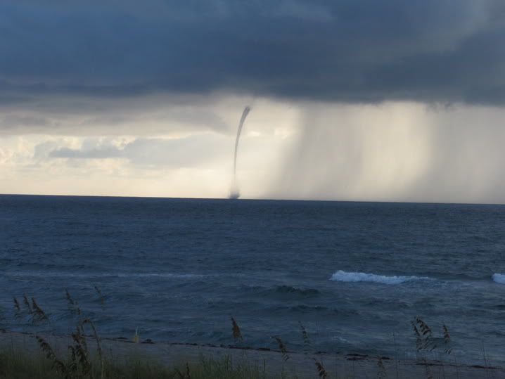
Not my picture.
442 posted on
08/28/2006 5:13:49 PM PDT by
sig226
(There are 10 kinds of people in the world: those who understand binary and those who do not.)
To: NautiNurse; All
618 posted on
08/28/2006 9:27:54 PM PDT by
SheLion
("If you're legal, you can fly with the Eagle!" - Michael Anthony)
FreeRepublic.com is powered by software copyright 2000-2008 John Robinson
