Note tropical storm warning at north end of the Lesser Antilles and tropical storm watch at Puerto Rico.
Note tropical storm warning at north end of the Lesser Antilles and tropical storm watch at Puerto Rico.

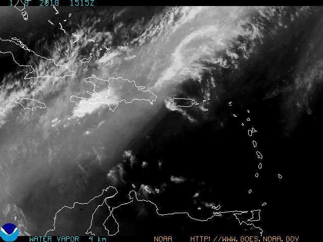
This image and the image in FlJoePa's reply 3 will periodically update automatically.
12 days and counting till the Kentucky and South Carolina Coleman's head out for their Walt Disney World vacation. This time of year was not my 1st, 2nd, or 3rd choice.
Thanks for the thread. Will keep a watchful eye to the skies.
I'll bet gas prices jump a nickel just on the news that a storm has been named.

My feeling now is that Chris should remain a significant tropical cyclone throughout the 120-h forecast period...which is in contrast to all of the global models and the GFDL model.
Forget all these dang compooters, I got me a FEELIN' !!!
Too early to tell but, this one could be headed for the Gulf. Weather guys in Austin already mentioning the possibility. We could really use the rain.
Aug 1st, right on schedule. It seems every year right at this time, the storms come out from hiding. Karl Rove must have his weather machine back from its spring overhaul.
...CHRIS HEADED TOWARD THE NORTHERN LEEWARD ISLANDS...
A TROPICAL STORM WARNING IS IN EFFECT FOR THE ISLANDS OF ANTIGUA...BARBUDA...ANGUILLA...ST. KITTS... NEVIS...SABA...ST. EUSTATIUS...ST. BARTHELEMY...ST. MARTIN...AND ST. MAARTEN. A TROPICAL STORM WARNING MEANS THAT TROPICAL STORM CONDITIONS ARE EXPECTED WITHIN THE WARNING AREA WITHIN THE NEXT 12 TO 24 HOURS.
A TROPICAL STORM WATCH IS IN EFFECT FOR PUERTO RICO AND THE U.S. VIRGIN ISLANDS...AND FOR THE BRITISH VIRGIN ISLANDS. A TROPICAL STORM WATCH MEANS THAT TROPICAL STORM CONDITIONS ARE POSSIBLE WITHIN THE WATCH AREA...GENERALLY WITHIN 36 HOURS.
FOR STORM INFORMATION SPECIFIC TO YOUR AREA...INCLUDING POSSIBLE INLAND WATCHES AND WARNINGS...PLEASE MONITOR PRODUCTS ISSUED BY YOUR LOCAL WEATHER OFFICE.
AT 800 AM AST...1200Z...THE CENTER OF TROPICAL STORM CHRIS WAS LOCATED NEAR LATITUDE 16.8 NORTH...LONGITUDE 59.8 WEST OR ABOUT 135 MILES...215 KM...EAST OF ANTIGUA.
CHRIS IS MOVING TOWARD THE WEST-NORTHWEST NEAR 9 MPH...15 KM/HR... AND THIS GENERAL HEADING IS EXPECTED TO CONTINUE OVER THE NEXT 24 HOURS. ON THE FORECAST TRACK...CHRIS IS EXPECTED TO MOVE OVER OR NEAR THE NORTHERNMOST LEEWARD ISLANDS LATER TONIGHT OR EARLY WEDNESDAY MORNING.
MAXIMUM SUSTAINED WINDS ARE NEAR 40 MPH...65 KM/HR...WITH HIGHER GUSTS. SOME STRENGTHENING IS FORECAST DURING THE NEXT 24 HOURS. AN AIR FORCE RESERVE RECONNAISSANCE AIRCRAFT IS SCHEDULED TO INVESTIGATE THE TROPICAL STORM THIS AFTERNOON TO PROVIDE A MORE ACCURATE ESTIMATE OF THE STRENGTH AND LOCATION OF CHRIS.
TROPICAL STORM FORCE WINDS EXTEND OUTWARD UP TO 35 MILES...55 KM FROM THE CENTER.
THE ESTIMATED MINIMUM CENTRAL PRESSURE IS 1009 MB...29.80 INCHES.
RAINFALL AMOUNTS OF 3 TO 5 INCHES...WITH ISOLATED HIGHER AMOUNTS TO NEAR 8 INCHES...ARE POSSIBLE OVER THE NORTHERN LEEWARD ISLANDS IN ASSOCIATION WITH CHRIS.
REPEATING THE 800 AM AST POSITION...16.8 N...59.8 W. MOVEMENT TOWARD...WEST-NORTHWEST NEAR 9 MPH. MAXIMUM SUSTAINED WINDS...40 MPH. MINIMUM CENTRAL PRESSURE...1009 MB.
THE NEXT ADVISORY WILL BE ISSUED BY THE NATIONAL HURRICANE CENTER AT 1100 AM AST.
$$
FORECASTER PASCH
According to the last year's season archive (at http://www.nhc.noaa.gov/2005atlan.shtml) we were already at nine storm/hurricanes in the Atlantic at about this time. They were:
Tropical Storm Arlene
Tropical Storm Bret
Hurricane Cindy
Hurricane Dennis
Hurricane Emily
Tropical Storm Franklin
Tropical Storm Gert
Tropical Storm Harvey
Hurricane Irene
This year we have so far only had three tropical storms: Alberto, Beryl and now Clyde.
Now the NOHC predicted in May (http://www.publicaffairs.noaa.gov/releases2006/may06/noaa06-056.html) that we would have a very active hurricane season and many in the press were reporting this as "doom and gloom".
So far (knock on wood), this season has been rather mild in the Atlantic. I am hoping that it stays this way but I guess the question is if it does "what happened"?
Another good thing right now is that Natural Gas production is doing quite well.
In fact, because of heat and high oil prices, there was good demand for Natural Gas, which is cheaper than oil right now and is cleaner burning.
Finally, there is an increase from about 306,000 producing natural gas wells in 1999 to about 402,000 producing natural gas wells in the United States.
Any shut in of natural gas is not the same impact as last year - there is considerably more natural gas in underground storage.
If anything, oil prices have propped up natural gas prices this summer.
I just hope TS Chris heads for Cuba or gets chewed by a large land mass before going elsewhere so that it is not a very powerful storm. The West Indies can take a lot of a hurricane if the TS keeps hitting the Carribean Islands on its path westward... My two cents worth...
http://orca.rsmas.miami.edu/wximages/jet/1_05/anis.html
It looks like Chris is heading straight north along longitude 65W north of the Lesser Antilles.
It also looks like it is losing whatever cohesion it had when this thread was started.