Skip to comments.
Is LA Governor Blanco Hiding "Imaginary" Levees? (4 x 100 KB images)
Posted on 09/14/2005 4:39:47 PM PDT by jeffers
Several media sources have reported that LA Governor Kathleen Blanco resisted and delayed federal efforts to send aid and relief to southern Louisiana, expressing concern that if the federal government became involved, they would lay all the blame on state and local officials. This is a matter of public record. What has yet to come to light are any details which might explain Governor Blanco's apparant insecurity.
This article from The New Orleans Times-Picayune, dated June 23, 2002, notes the following significant points:
1. The New Orleans area's last line of defense against hurricane flooding is a 475-mile-long system of levees, locks, sea walls and floodgates averaging about 16 feet high. The Army Corps of Engineers says the system will protect the city and suburbs from a Category 3 hurricane that pushes in enough seawater to raise Lake Pontchartrain 11.5 feet above sea level -- high over the head of anyone standing on the other side of a levee.
That margin of error is critical because a storm that pushes the lake any higher can force water over the top of the levees and inundate the city. The water could quickly rise 20 feet or higher. People would drown, possibly in great numbers.
The corps doesn't know what that safety margin is anymore. Generally speaking, the corps says the powerful, slow-moving storms capable of overwhelming the system are rare and the levees are safe. But corps engineers say their own safety estimates are out of date, and an independent analysis done for The Times-Picayune suggests some levees may provide less protection than the corps maintains.
2. Measuring the risks of disaster is a technical feat that few understand. But such exercises are critical to the future of New Orleans. If the new corps study confirms that protection is less than previously thought, the answers could have major effects on issues such as flood insurance rates, future levee expansions, emergency planning, evacuation and long-term business decisions.
3. The landscape also is changing because of coastal erosion, sinking and even levee building.
4. Levee heights along the Mississippi River-Gulf Outlet and Intracoastal Waterway in the area range from 17.5 to 19 feet. Butler's estimates put the 100-year flood level at 16.3 feet above sea level, meaning waves on top of that would wash over the top and flood areas inside.
The historical record tends to confirm these results, Butler said. "All along the levee, there has been very high water measured there for several storms, certainly in Betsy. If you had the right kind of storm come in there, you'd really be in trouble."
http://homepages.uc.edu/~maynarjb/105/NewOrleans/NewOrleans_hurricanes.htm
In 1999, NASA launched shuttle mission STS-99, a 17 day effort which mapped over 80% of planet Earth, to a resolution of 1 meter per pixel or better, a flight more commonly referred to by computer mapping specialists as SRTM-99, short for Shuttle Radar Tomography Mission, 1999.
The 1 meter per pixel datasets are highly classified by the US military, however, the 10 meter per pixel and 30 meter per pixel datasets have been released into the public domain. These are available for download here, among other places:
http://data.geocomm.com/
Digital Elevation Models (DEMs) indicate that in 1999, levees east of St. Bernard Parish were not then at their originally specified heights above sea level. While it is possible that those sections fell victim to equipment malfunction or image resolution averaging, the following composite images demonstrate that any such failure would have had to have been highly selective.
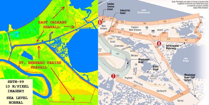
The image above shows elevation data for St. Bernards Parish as of 1999, using mapping software calibrated to a normal sea level. Relevent levee systems are artificially highlighted in red.
In the next image below, sea level has been digitally increased to six feet above normal.
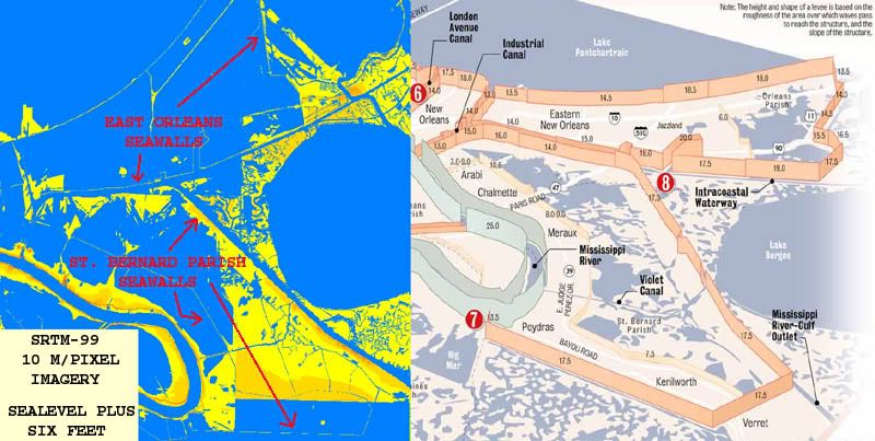
In the above image, nearly all major sections of the levee/seawalls are still visible, as they should be if they are indeed 17 feet above sea level. However, the following two images clearly show that at sea levels of eight feet above normal, large sections of the St. Bernards Parish seawall/levee system are no longer visible.
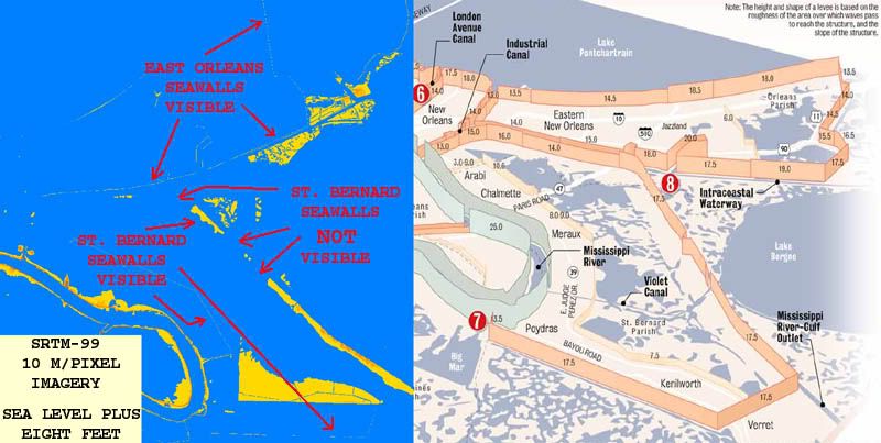
Note missing levee sections above.
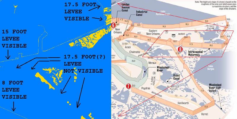
A closer view of selected portions of image three.
These disturbing images leave no choice but to raise the following questions:
1. How often were these sections of the levee seawall system inspected?
2. Have they been inspected since 1999?
3. What method(s) were used during post 1999 levee inspections to determine the actual height of these structures? GPS? Laser level circuit from a known and tested benchmark? Optical transit or dumpy level circuit from a known and tested benchmark? Eyeball estimate?
4. Were these inspections carried out on the ground or by aerial survey?
5. Were any discrepancies noted during these assumed inspections?
6. What actions were taken to remedy any problems found during these inspections?
7. If it was found that subsidence had indeed lowered the seawall/levee structures, who was informed of these discrepancies, and when were they made aware of them?
8. If no discrepancies were noted, then why do high resolution shuttle radar images clearly show seawalls measured at 8, 15, and 17.5 feet, while not showing seawalls which supposedly top out at 17 feet in other nearby locations?
Given that St. Bernards Parish was the first area to flood during Hurricane Katrina, and that this area will likely yield the highest body count, these are questions that demand answers.
It is no secret that the missing levee sections noted in the above imagery include those areas most likely to fail in the event a storm surge is funneled from Lake Borgne into the Intercoastal Waterway. If these sections had already subsided and sank as far back as 1999, and local and state officials cannot document repairs since then, at the very least the public has been falsely assured, and by the reckoning of some, charges of negligence or even malicious negligence may not be out of order.
TOPICS: Crime/Corruption; Culture/Society; Government; Miscellaneous; News/Current Events; Technical; US: Louisiana; Your Opinion/Questions
KEYWORDS: failure; flood; hurricane; katrina; levee; neworleans; shuttle; space; surge
Navigation: use the links below to view more comments.
first previous 1-20, 21-40, 41-46 next last
To: hummingbird
21
posted on
09/14/2005 6:29:44 PM PDT
by
dangus
To: Arkie2
The local governmental divisions, parishes, have levee boards with intitial responsibility.
22
posted on
09/14/2005 7:52:43 PM PDT
by
Mind-numbed Robot
(Not all that needs to be done needs to be done by the government.)
To: Mind-numbed Robot
Then the question would be did they relay any concerns to the Corps of Engineers?
I still have a hard time believing the Corps is subservient to local authorities in matters of inspection of these levees.
A previous post raised the issue of concrete topped levees and whether they would have been apparent to the satellite photos. Good question.
23
posted on
09/14/2005 8:06:00 PM PDT
by
Arkie2
(Mega super duper moose, whine, cheese, series, zot, viking kitties, barf alert!)
To: jeffers
24
posted on
09/14/2005 8:43:26 PM PDT
by
UnbelievingScumOnTheOtherSide
(Give Them Liberty Or Give Them Death! - IT'S ISLAM, STUPID! - Islam Delenda Est! - Rumble thee forth)
To: Arkie2
I did a search (Google) and came up with some interesting links. I ended up with the impression that the Corp of Engineers was responsible for the levees on the Mississippi River and navigable waterways but the Parishes, through their levee boards, were responsible for the others. A Corp of Engineers engineer said the part of the 17th Street levee that broke had recently been upgraded.
It seems to me that the problem is increased subsidence. As the Gulf encroaches from the south and southwest, and that is where St. Bernard Parish is, the subsidence increases. As they add to the levees to increase their height they also increase their weight, perhaps making them subside even more.
25
posted on
09/15/2005 6:29:25 AM PDT
by
Mind-numbed Robot
(Not all that needs to be done needs to be done by the government.)
To: Eepsy
26
posted on
09/15/2005 7:06:53 AM PDT
by
Eepsy
To: Semper911
You know just as well as I do how long it took the levees to settle ten feet. They were built in 1965 when the MRGO was first dredged, and they were as low as 6.6 feet in 1999 when the shuttle took their picture.
The mechanism is also clear. Imagery from shortly after the MRGO was built shows it to be about a third as wide as it is now. See the pictures here:
http://www.louisianasportsman.com/stories/2003/paradise-lost/future-of-mrgo.htm
The combined effects of daily tides, the wakes from passing freighters, saltwater incursion which killed the freshwater plants growing in the area and lesser storms caved in the banks of the waterway, allowing the marshy land under the levees to slump. In the last image from the lik above, you can visibly see the low spots in the levee just by following the top of it with your eyes. There is a low spot dead center in the frame, and another halfway from there to the lower left. Further up and to the right, you can see a straight line which bisects the levee's profile, giving you a clear idea of what a cross section of the levee looks like.
Well off in the distance, you can see where the levee starts to regain its original heigth. Now traverse back down the shoreline to the low spot centered in the image.
See the "missing" gouge out of the coastline? Had the levee held its shape when that gouge peeled off and slid down into the channel, the gouge would have been even deeper, but the levee slumped and the soil assumed it's natural angle of repose, two different angles actually, one above and one below the waterline.
You don't build permanent structures out of sludge, because it tends to flow and flatten when it gets wet. Note also that this article was posted in 2003.
Also, this thread here at FR:
http://www.freerepublic.com/focus/news/1484878/posts?page=1
contains an article from the WSJ which admits the subsidence, and that nothing was done about it.
"Joseph Suhayda, a retired Louisiana State University coastal oceanographer, who told the Journal he suspects the levees aren't actually that tall, partly due to sinking of the land beneath them. Mr. Suhayda
now consults for a maker of flood-protection barriers. If he's right, that would mean the levees weren't high enough to handle even a Category 2 or 3 hurricane. Katrina was nearly a Category 5.
The Corps of Engineers concedes some of its levees in the area "have settled and need to be raised to provide" the level of protection for which they were designed, according to a fact sheet on the Corps's
Web site dated May 23, 2005. But federal budget shortfalls in fiscal 2005 and 2006 "will prevent the Corps from addressing these pressing needs." Even had sufficient funds been available the work could not
have been completed in time to prevent the Katrina floods."
Note the attempted spin there, as if the subsidence had just been detected and the Federal cuts for 2005 and 2006 determined the outcome of an issue that's been a problem for at least 6 years now.
The real beauty of all this is that the good stuff, the 1 meter per pixel datasets, are already in the hands of the Feds, if they have the will to use them.
27
posted on
09/15/2005 7:13:22 AM PDT
by
jeffers
To: ZOOKER
The concrete wall levees do show up in the sat imagery. Along the south side of east Orleans Parish you can see one, and out of the frame to the left, there is another that is visible from alongside the Industrial Canal.
Even though the concrete wall is smaller than a single ten meter pixel in the DEM dataset, it does affect the pixel's heigth value, representing an average of the total area covered by the 10 meter square. This is an effect I've seen before in Landsat visible imagery. 4 meter wide roads and trails are clearly visible in the Landsat 7 datasets which only have a resolution of 28.5 meters per pixel. Even though the road is not wide enough to color an entire pixel, its color is enough to change the average value of that pixel from those immediately adjacent to it on either side.
Because it is a linear feature, the pattern is clear, where a single 4 meter by 4 meter feature would more likely be dismissed as an aberration.
28
posted on
09/15/2005 7:21:51 AM PDT
by
jeffers
To: Mind-numbed Robot; Arkie2; Ellesu
That is my impression as well.
The local levee board makes the decisions and recommendations, raises awareness and local and state financial support, then the Corps comes in with matching federal funds, and does the grunt work.
From searching "New Orleans Levee Board" and "corrupt", and also from excellent research doen by Ellesu here at FR, I sincerely douibt that any member of the Levee Borad ever gets their hands dirty with actual marsh muck. They are too busy spending the 30 million dollars they stole and spent on expensive toys and trips, harassing local reporters with sub-rosa and illegal investigations, planning multi- million dollar resort islands, yacht clubs and casinos, and putting together straw corporations which do the "work" of siphoning off federal funds into Levee Board pockets.
Run your own search just for fun, you'll see what I mean.
29
posted on
09/15/2005 7:29:22 AM PDT
by
jeffers
To: jeffers
... and putting together straw corporations which do the "work" of siphoning off federal funds into Levee Board pockets. There is the conduit that is often missed. These "corporations" get the contracts and then subcontract the real work while taking a large portion for themselves. The same thing may be happening now with the hiring of the company to recover the bodies in New Orleans and surrounding environs. The federal FEMA folks were balking at hiring that bunch so Blanco blamed them for not acting and hired the company herself. That is a contract worth scrutiny.
30
posted on
09/15/2005 7:55:21 AM PDT
by
Mind-numbed Robot
(Not all that needs to be done needs to be done by the government.)
To: jeffers
AUDIT OF LEVEE DISTRICT FINDS SLOPPY CONTRACTS
Times-Picayune, The (New Orleans, LA)
October 4, 1997
Author: BILL WALSH Capital bureau
Estimated printed pages: 2
BATON ROUGE The Orleans Parish Levee District has mismanaged some of its professional service contracts and one of its consultants may have also run afoul of state ethics laws, the state's chief auditor said.
Legislative Auditor Dan Kyle criticized the Levee District for entering into verbal instead of written contracts and paying consulting fees without approval from the appointed board members.
Some of the written contracts don't have cancellation clauses, forcing the district to pay the full amount of the contract even if it wants out early, the audit found.
"It's very poor business practice," Kyle said. "Lack of the termination clauses in past professional services contracts has cost the Levee District and the taxpayers hundreds of thousands of dollars."
The leadership of the Orleans Levee Board has been criticized by lawmakers for its handling of money. James Huey, who was elevated to board president in a shake-up last year, has blamed many of the problems on previous administrations.
Kyle said the new leadership has tightened contractual policies significantly.
"Some of these findings are the remnants of the past administration," Kyle said. "They have cleaned up some things. They have a new attitude."
Criticisms of the new administration included paying $94,386 to a computer consultant without a contract and failing to include cancellation clauses in two other contracts.
Meanwhile, the audit charged that the former administration of Levee Board President Bob Harvey contracted with ACETECH Inc., a computer consulting firm, without board approval. The agency paid $375,000 to settle the contract, according to the audit.
The Levee District, which is in charge of maintaining the levees around Orleans Parish, also paid $198,290 to Design Engineering Inc., based on a verbal contract.
Kyle said Design Engineering may have also violated the state ethics code by charging $198,290 for a lease it negotiated on behalf of the Levee District and then accepting $546,537 from Bally's Casino Co. to develop the land.
A spokesman for the Levee District did not return a telephone call for comment. Design Engineering employees referred all questions to company president Walter Baudier, who was not available for comment.
http://www.nola.com
31
posted on
09/15/2005 8:53:17 AM PDT
by
Ellesu
(www.thedeadpelican.com)
To: Mind-numbed Robot; Ellesu
Precisely.
While the levees continued sinking below 6.6 feet high, the Levee Board in charge of them were not only spending 2 million dollars planning a resort island in Lake Pontchartrain, they were also setting up companies to benefit from it.
It's not an isolated case either. from the reports Ellesu has dug up and my own effort, the whole machine is riddled with stories like this. The levees failed because nobody was watching them.
There's pictures, there's shuttle data, and there are indictment after indictment proving this.
The only way the local and state political machine gets off is if Bush allows them to, in view of some larger picture. If he chooses that route, he'd best be convincing. I'm extremely angry at the lefties who attacked wheil we were busy trying to save lives, and tat isn't going away at the drop of a hat, no matter who asks for it to disappear.
32
posted on
09/15/2005 9:17:57 AM PDT
by
jeffers
To: jeffers
Abuse found in program steering work to disadvantaged businesses
The Advocate (Baton Rouge, La.)
November 27, 2003
Estimated printed pages: 2
NEW ORLEANS - Programs at three New Orleans-area public agencies that steer work to companies owned by women or minorities were rife with abuse and poorly run, according to an investigative report from the federal Transportation Department.
The investigation covered disadvantaged business enterprise programs operated by Louis Armstrong New Orleans International Airport, the Regional Transit Authority and the Orleans Levee Board.
All three agencies receive money from the federal transportation agency.
In all, the investigation examined more than $100 million in contracts between 1999 and 2002 and the DBE certifications of the companies receiving them.
The investigation found deficiencies and outright violations of federal regulations at all three agencies, officials said.
Program managers at the Levee Board and the RTA did not conduct required site visits for as many as 50 percent of the companies they certified, the report said.
Several certified firms were controlled by nonminorities and, in some cases, the firms were merely fronts, the report said.
The agency's investigation was requested by U.S. Rep. David Vitter, R-Metairie, in 2001 after The Times-Picayune of New Orleans ran a series of articles questioning the operation of the disadvantaged business program.
"Our investigation substantiated many of the alleged abuses in the DBE programs reported in the Times-Picayune series, and we encountered many of the same problems in the DBE programs in New Orleans as we have seen in other DBE programs across the country," said the report, signed by Transportation Department Inspector General Kenneth Mead.
Vitter credited the local agencies for reforms they have already initiated and said the administration of New Orleans Mayor Ray Nagin is "moving in the right direction."
Earlier Tuesday, Nagin announced a series of changes to the city's DBE programs. Nagin has sharply criticized the way his predecessor, Marc Morial, awarded some DBE contracts.
But Nagin said his overhaul should be seen as an effort to improve and expand the programs, not as an indictment of them. The goal, he said, is for New Orleans "to become the entrepreneurial capital of America."
The transportation department said it believed that more than 60 percent of the contracts awarded under the program were influenced by political patronage. The investigation also found several DBE company owners who exceeded the department's $750,000 limit on net worth.
U.S. Attorney Jim Letten also has been exploring aspects of the city's DBE programs as part of a criminal probe into corruption at City Hall. Letten's office has subpoenaed various documents, including the applications of numerous businesses seeking to be certified as disadvantaged.
Vitter said the Transportation Department report in some ways is "astounding" because 60 percent of vendors interviewed said they believed they needed to make political contributions to get work.
But Vitter said there already has been "enormous improvement and cleanup" of oversight at the three agencies studied.
"The real victims here are minority and other disadvantaged businesses that this program is supposed to help," Vitter said.
http://www.2theadvocate.com
33
posted on
09/15/2005 9:46:40 AM PDT
by
Ellesu
(www.thedeadpelican.com)
To: jeffers
"If the new corps study confirms that protection is less than previously thought, the answers could have major effects on issues such as flood insurance rates, future levee expansions, emergency planning, evacuation and long-term business decisions."
Right there is your answer as to why Blanco did not stand on the roof screaming to have something done ... "major effects on issues such as ... long-term business decisions."
34
posted on
09/15/2005 9:56:33 AM PDT
by
zeaal
(SPREAD TRUTH!)
To: Ellesu
They've been having quite a party down there, for several decades it seems.
I've got a feeling that the party takes a big hit tonight. Maybe not on the surface, but I just can't see where Dub's going to hand a hundred bill to known crooks.
35
posted on
09/15/2005 9:56:55 AM PDT
by
jeffers
To: jeffers
I really hope you are correct.
Real estate pioneer, planner John Henry Ross, dead at 63
The Advocate (Baton Rouge, La.)
August 4, 1995
APBy AP
Estimated printed pages: 1
NEW ORLEANS - John Henry Ross Sr., one of the first black real estate brokers in New Orleans, has died of lung cancer. He was 63.
Ross, a former member of the Orleans Levee Board and New Orleans Aviation Board, died Tuesday at his home.
A funeral will be held Saturday at All Faiths Funeral Home in New Orleans. Burial will be in Bunker Hill Cemetery in Woodville, Miss.
Ross was released from a federal prison July 10 after serving three years and seven months for bribery and obstruction of justice.
He was convicted in 1991 along with former U.S. District Judge Robert F. Collins of New Orleans.
Both were convicted of accepting $100,000 in payoffs from restaurateur Gary Young so Young would get a lenient sentence from Collins in a marijuana smuggling case in 1990.
Authorities said Young, acting as an informant for the FBI, passed bribe money to Ross which Ross said would be given to Collins.
Federal authorities said about $16,000 of the money supplied to Young by the FBI was found in Collins' chambers, and nearly all of the rest was found in Ross' possession.
Ross was born in Galveston, Texas, and lived in New Orleans for 37 years. He was a graduate of Central High School in Galveston and Southern University in Baton Rouge.
He served as a senior planner for New Orleans' Regional Planning Commission for more than 20 years and as a Levee Board member for 15 years.
He was a member of the Southern Organization for Unified Leadership, the Southern Christian Leadership Conference, the National Association for the Advancement of Colored People and the Prince Hall Masons. He served in the Air Force for four years.
http://www.2theadvocate.com
36
posted on
09/15/2005 9:58:44 AM PDT
by
Ellesu
(www.thedeadpelican.com)
To: jeffers
One of the best posts I have seen on FR. It will be interesting to see if the press follows it up. Those 34 old people may have more people paying for their lives than the owners.
37
posted on
09/15/2005 10:00:38 AM PDT
by
Nov3
("This is the best election night in history." --DNC chair Terry McAuliffe Nov. 2,2004 8p.m.)
To: All; jeffers
Too many articles to post them all, but here is one more.
INSPECTOR RIPS LEVEE BOARD'S ADMINISTRATOR
Times-Picayune, The (New Orleans, LA)
January 24, 1997
Author: FRANK DONZE Staff writer
Estimated printed pages: 2
The Orleans Levee Board's top administrator repeatedly violated board policy while executing a $1.3 million contract extension with a computer consulting firm, according to a report by the state inspector general.
In a draft report given to the board this week, Inspector General Bill Lynch is harshly critical of Theodore Lange, the agency's managing director since 1994.
Lange last spring survived an attempt by the board's former president, William Nungesser, to oust him.
Lynch's report alleges several transgressions by Lange, who signed the contract extension in December 1995, including his failure to:
Get the board's authority to execute the document.
Submit it for review by the board's legal counsel.
Notify state civil service officials, as required by law.
Further, Lynch charges, the contract contained several provisions advantageous to the computer company, Acetech Inc., that had not been discussed by the board, including $250,000 for out-of-pocket expenses, extensions through 2002 and penalties if the board terminated the contract without cause.
As a result of Lange's alleged mishandling of the agreement, Lynch suggested the board "should determine if it should take disciplinary action against the managing director." He gave Lange until Jan. 31 to respond to the report before he submits it to Gov. Foster.
Board sources said this week that Lynch's report could provide the impetus for the board to fire Lange. Several members have grown increasingly disillusioned with Lange over the past year.
Board President James Huey said Lange will have a full opportunity to respond to Lynch's charges. But he said he thinks Lynch's findings are accurate and that Lange's actions ultimately will be the subject of a full review by the board.
Patrick Klotz, Lange's attorney, called the board "irresponsible" for releasing what he said is an incomplete analysis that fails to include Lange's side of the story.
"These charges were addressed and found to be baseless six months ago," Klotz said. "It's a travesty to attempt to bring these issues up again."
As managing director, Lange, who has worked for the Levee Board since the 1970s, oversees a $24 million annual operating budget, tens of millions of dollars in capital improvement projects and about 300 workers.
http://www.nola.com
38
posted on
09/15/2005 10:03:26 AM PDT
by
Ellesu
(www.thedeadpelican.com)
To: jeffers
Question could the 10 meter resolution "miss" the peak of the levees. 33 feet bracketing the top of a levee could result in a lower elevation by 5 foot or more.
39
posted on
09/15/2005 10:03:31 AM PDT
by
Nov3
("This is the best election night in history." --DNC chair Terry McAuliffe Nov. 2,2004 8p.m.)
To: satchmodog9
I agree with you....
The template is set....
And no amount of factual accounting will change it.
Navigation: use the links below to view more comments.
first previous 1-20, 21-40, 41-46 next last
Disclaimer:
Opinions posted on Free Republic are those of the individual
posters and do not necessarily represent the opinion of Free Republic or its
management. All materials posted herein are protected by copyright law and the
exemption for fair use of copyrighted works.
FreeRepublic.com is powered by software copyright 2000-2008 John Robinson