Excuse me, but what do you think "Mississippi river silt" has to do with breaching levees?? The levees that might be breached are on Lake Ponchartrain---not the Mississippi, and the silt load of the Mississippi is dropped WAY out in the Gulf (which is why the swamplands are eroding---LACK of silt, not too much). Tell me...why is the silt being deposited way out into the Gulf? Because the natural distributary process has been subverted! I'm not talking about today...think longer-term and broader.
Secondly, levees could breach in multiple places. Lake Pontchartrain AND the river...but that's not the point. Why is there a levee for Lake P.? Perhaps because of its elevation relative to the the developed areas? Why such a difference? Again, think of long-term policies, not just today.
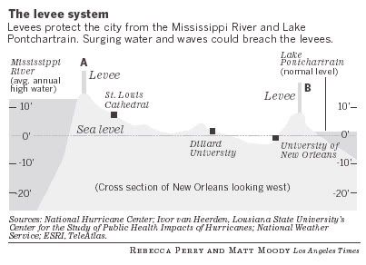
(And I note that the river elevation is "high," and the lake elevation is the "normal.")
The most likely weak link for a catastrophic breach is actually the west side levee, which is the lowest at 10'. Because the topside winds have been blowing to the west and then southwest before eventually coming out of the north, all that water blown in the lake are first pushed towards the spillway to the SW of the lake, and the first danger is that builds up so much as to overtop the west side. Now as the eye moves even to the city on the east side, the worst danger area expands to the city's north shore, as the winds max and shift to coming straight out of the north.
Also people may not realize that there are levees separating the main area of NO and the city's northeast side, the closest side to the eye. So it is possible that one could see catastrophic flooding while the other does not. Time will tell.
"Tell me...why is the silt being deposited way out into the Gulf? Because the natural distributary process has been subverted! I'm not talking about today...think longer-term and broader." Still don't see why Mississippi River silt has anything whatsoever to do with New Orleans possibly flooding. The "fouled up" silt deposition is why the coastal swamps shoreline are creeping north, not why New Orleans is below sea level. Of course, fixing that silt distribution would be very easy---just cut two "east-west" channels well up the isthmus---one from the Missippi towards the east, and one from the Mississippi towards the west.
"Secondly, levees could breach in multiple places. Lake Pontchartrain AND the river...but that's not the point. Why is there a levee for Lake P.? Perhaps because of its elevation relative to the the developed areas? Why such a difference? Again, think of long-term policies, not just today."
Breaching of the Mississippi River levees by a hurricane is so unlikely as to approach zero, as the levees are higher compared to Ponchartrain. The reason New Orleans is below sea level is because the LAND IS SINKING, due to the huge weight of all the buildings (built on Jello), and the pumping out of groundwater. Again--nothing to do with river silt.
"(And I note that the river elevation is "high," and the lake elevation is the "normal.")"
I assume you mean that for your graphic, which probably represents the Mississippi level at "flood stage", which only occurs in early spring. The river level during hurricane season is obviously much lower.