Posted on 08/25/2005 11:51:53 PM PDT by NautiNurse
Katrina is emerging into the very warm waters of the Gulf of Mexico early this morning after making landfall in SE Florida, then tracking SW. Thus far, she is well ahead of schedule, leaving at least four fatalities in her wake, and well over 1 million without electricity.
The following links are self-updating.
Public Advisory Currently published every 3 hours 5A, 8A, 11A, 2P, etc. ET
NHC Discussion Published every six hours 6A, 11A, 6P, 11P
Three Day Forecast Track
Five Day Forecast Track
Navy Storm Track
Katrina Track Forecast Archive Nice loop of each NHC forecast track for both three and five day
Forecast Models
Alternate Hurricane Models via Skeetobite
Buoy Data Florida
Images:
Key West Experimental Radar Subject to delays and outages - and well worth the wait
Tampa Bay Long Range Radar Loop
Storm Floater IR Loop
Storm Floater Still & Loop Options
Color Enhanced IR Loop
Other Resources:
Florida East Coast Surf Reports Lots of great info here, including surf cams
Central Florida Hurricane Center
Hurricane City
Hurricane Katrina Live Thread, Part I
| Category | Wind Speed | Barometric Pressure | Storm Surge | Damage Potential |
|---|---|---|---|---|
| Tropical Depression |
< 39 mph < 34 kts |
Minimal | ||
| Tropical Storm |
39 - 73 mph 34 - 63 kts |
Minimal | ||
| Hurricane 1 (Weak) |
74 - 95 mph 64 - 82 kts |
28.94" or more 980.02 mb or more |
4.0' - 5.0' 1.2 m - 1.5 m |
Minimal damage to vegetation |
| Hurricane 2 (Moderate) |
96 - 110 mph 83 - 95 kts |
28.50" - 28.93" 965.12 mb - 979.68 mb |
6.0' - 8.0' 1.8 m - 2.4 m |
Moderate damage to houses |
| Hurricane 3 (Strong) |
111 - 130 mph 96 - 112 kts |
27.91" - 28.49" 945.14 mb - 964.78 mb |
9.0' - 12.0' 2.7 m - 3.7 m |
Extensive damage to small buildings |
| Hurricane 4 (Very strong) |
131 - 155 mph 113 - 135 kts |
27.17" - 27.90" 920.08 mb - 944.80 mb |
13.0' - 18.0' 3.9 m - 5.5 m |
Extreme structural damage |
| Hurricane 5 (Devastating) |
Greater than 155 mph Greater than 135 kts |
Less than 27.17" Less than 920.08 mb |
Greater than 18.0' Greater than 5.5m |
Catastrophic building failures possible |
Yikes if it goes just West of Lake Ponchetrain, and the east side blows south, that will push the lake into and fill the bowl that the city is in if the winds are strong enough. The dikes cannot stop that. That has always been the ultimate NO fear.
The Charley evac was amazing. First St. Pete, then Tampa, then Manatee Co. It went like clockwork. Of course, I waited until they chased me out...was only gone for about 4 hours.
Hurricane Betsy: The Sequel
Thanks again, NautiNurse, for puttting up this thread. Glad to have this resource.
I spent the day doing a temporary repair on my roof in anticipation of Katrina coming this way. When I started this AM, she was "tracked" for the Panama City area. I'm relieved she'll head somewhere else although I pray the damage will be minimal.
My bees are still agitated from the effects of Dennis. I've been stung several times just by walking by the hives. Cantankerous ladies in those boxes. I'm sure they are pleased too.
Will keep a close watch this weekend.
miele man
Please ping me with Thread III. Goodnight all.
Great to see you check in here! Sorry to hear about the neurotic bees. Glad you will be with us for this scary storm.
Let's hope for Hurricane Lili, The Sequel. Everybody was sure CAT 4 Lili was going to wipe out New Orleans, then it weakened to CAT 1 just before landfall and didn't wind up doing much.
Better yet, maybe it will just keep drifting southwest...
GOVERNOR BLANCO TO HOLD PRESS BRIEFING
BATON ROUGE-On Saturday, August 27, 2005 at 7:30 a.m., Governor Kathleen Babineaux Blanco will participate in the Southeastern Louisiana parishes Conference Call at the Louisiana Office of Homeland Security and Emergency Preparedness (LHLS & EP). The Governor will join federal, state, and parish officials as they receive the latest information on Hurricane Katrina and discuss emergency preparations in the southeastern Louisiana parishes.
At the conclusion of the conference call, Governor Blanco will conduct a briefing for the news media at the LHLS & EP.
. Governor's press briefing re Hurricane Katrina
. Following 7:30 a.m. conference call with Southeast Parishes
. Louisiana Office of Homeland Security & Emergency Preparedness
7667 Independence Blvd
Baton Rouge, LA
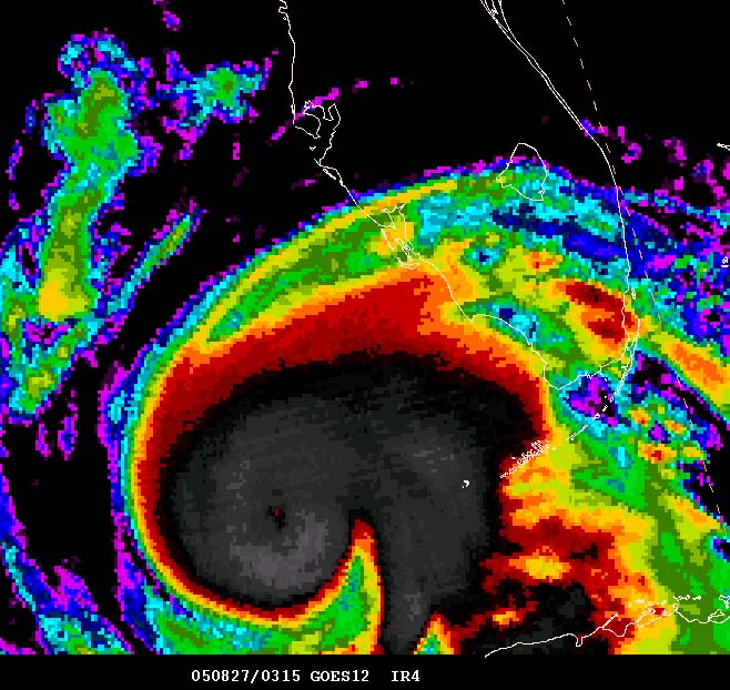
We now have an eye
http://www.usawx.com/august26fridaynighteyeformedy.jpg
We are all hoping for that, seriously, anywhere but New Orleans. Those waters are so warm though, I don't see anything less than a 3 wherever it makes landfall.
By Saturday night, the forecast for Dallas is a chance of thunderstorms......does that mean the high will be moving east and that's when Katrina is supposed to turn north?
It was horrible. I just pray for those poor people who don't have transportation. Where do they go?
Learn about the LOOP....If Katrina hits Louisana it will probably be gone...
Louisiana Offshore Oil Port
The Louisiana Offshore Oil Port (LOOP) is a deepwater port in the Gulf of Mexico off the coast of Louisiana near the town of Port Fourchon. LOOP provides tanker offloading and temporary storage services for crude oil transported on some of the largest tankers in the world. Most tankers offloading at LOOP are too large for U.S. inland ports. LOOP handles 13 percent of the nation's foreign oil and connects by pipeline to 35 percent of the U.S. refining capability.
http://en.wikipedia.org/wiki/Louisiana_Offshore_Oil_Port
http://www.dotd.louisiana.gov/programs_grants/loop/loop.shtml
Did you happen to look at the new evac map they put out a few weeks ago?
Our neighborhood was crazy, there would be three levels of evac on the same street.
Our part of the street was in an evac E zone, but I couldn't figure out how one end of the street would be in one evac zone and the other in another evac zone(Our street is only 2 blocks long.)
I think somebody had one too many when they drew the map, LOL.
They also made the Judicial Bldg downtown into a pet friendly shelter. I thought that was a good thing for all the folks in high rises downtown who will need to evacuate and have pets.
NEW Katrina thread?
http://www.freerepublic.com/focus/f-news/1471674/posts
Satellite loop has really gone impressive the past few images. I think winds will be minimum 125 at the 2am update.
Yeppers she is getting bigger. Moving more southwest now I believe. Satellite blackout for the next few hours.
About time for bed.
"What if Ivan Had Hit New Orleans?
New Orleans was spared, this time, but had it not been, Hurricane Ivan would have:
Pushed a 17-foot storm surge into Lake Pontchartrain;
Caused the levees between the lake and the city to overtop and fill the city “bowl” with water from lake levee to river levee, in some places as deep as 20 feet;
Flooded the north shore suburbs of Lake Pontchartrain with waters pushing as much as seven miles inland; and
Inundated inhabited areas south of the Mississippi River. Up to 80 percent of the structures in these flooded areas would have been severely damaged from wind and water. The potential for such extensive flooding and the resulting damage is the result of a levee system that is unable to keep up with the increasing flood threats from a rapidly eroding coastline and thus unable to protect the ever-subsiding landscape.
Evacuation Challenges
Researchers have estimated that prior to a “big one,” approximately 700,000 residents of the greater New Orleans area (out of 1.2 million) would evacuate. In the case of Hurricane Ivan, officials estimate that up to 600,000 evacuated from metropolitan New Orleans between daybreak on Monday, September 13 and noon on Wednesday, September 15, when the storm turned and major roads finally started to clear.
To aid in the evacuation, transportation officials instituted contraflow evacuation for the first time in the area’s history whereby both lanes of a 12-mile stretch of Interstate 10 were used to facilitate the significantly increased outbound flow of traffic toward the northwest and Baton Rouge. The distance of the contraflow was limited due to state police concerns about the need for staff to close the exits. And, although officials were initially pleased with the results, evacuees felt the short distance merely shifted the location of the major jams.
These feelings were justified by the amount of time it took residents to evacuate—up to 11 hours to go the distance usually traveled in less than 1.5. For many who evacuated into Texas, total evacuation time frequently exceeded 20 hours. Since the storm, a consensus has developed that to alleviate this congestion much more secondary highway coordination is necessary throughout the state, contraflow needs to be considered for much greater distances, residents who are able and willing to evacuate early must be doubly encouraged to do so, families with multiple cars need to be discouraged from taking more than one unless they are needed to accommodate evacuees, and all modes of transportation in their various configurations must be fully considered for the contributions they can make to a safe and effective evacuation.
The major challenge to evacuation is the extremely limited number of evacuation routes, which is the result of the same topography and hydrology responsible for the area’s high level of hurricane risk. The presence of the Mississippi River, several lakes and bays, and associated marshes and swamps necessitates very expensive roadway construction techniques that are generally destructive to the environment, making the addition of more arteries increasingly challenging. This problem of limited evacuation routes also plagues the rest of the delta plain of southeast and south central Louisiana.
The fact that 600,000 residents evacuated means an equal number did not. Recent evacuation surveys show that two thirds of nonevacuees with the means to evacuate chose not to leave because they felt safe in their homes. Other nonevacuees with means relied on a cultural tradition of not leaving or were discouraged by negative experiences with past evacuations.
For those without means, the medically challenged, residents without personal transportation, and the homeless, evacuation requires significant assistance. The medically challenged often rely on life support equipment and are in such fragile states of health that they can only be moved short distances to medically equipped shelters. While a large storm-resistant structure with appropriate equipment has yet to be constructed or retrofitted, the Superdome was used to shelter nonevacuees during Ivan.
Residents who did not have personal transportation were unable to evacuate even if they wanted to. Approximately 120,000 residents (51,000 housing units x 2.4 persons/unit) do not have cars. A proposal made after the evacuation for Hurricane Georges to use public transit buses to assist in their evacuation out of the city was not implemented for Ivan. If Ivan had struck New Orleans directly it is estimated that 40-60,000 residents of the area would have perished."
=================================
New Orleans best have an efficient and very detailed plan, and be ready to EXECUTE IT NOW:
I'm somewhat familiar with it. If it hits there, I don't even want to know how high the gas will go. It won't be pretty at all.
Disclaimer: Opinions posted on Free Republic are those of the individual posters and do not necessarily represent the opinion of Free Republic or its management. All materials posted herein are protected by copyright law and the exemption for fair use of copyrighted works.