It's kind of surreal, since right now (1313 EST) the weather is just another overcast day -- you'd never guess what's coming.

Posted on 08/13/2004 6:56:12 AM PDT by JesseHousman
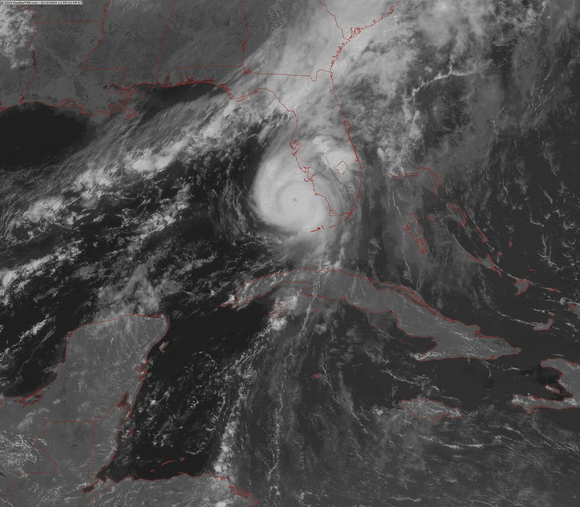
TAMPA, Fla. - With a "scary, scary" Hurricane Charley zeroing in on Florida's west coast Friday, state officials urged almost 2 million tourists and residents to evacuate and avoid the path of a storm that could submerge parts of this city's downtown and other neighboring areas.
Charley's expected 120 mph top sustained winds and massive storm surge could devastate coastal and low-lying areas in Tampa and St. Petersburg. Everything from waterfront condominium towers to vulnerable mobile homes were in danger on the Gulf Coast.
Charley's center was expected to pass west of the Florida Keys early Friday before hitting the Tampa Bay area later in the day, dumping heavy rain and possibly spawning sporadic tornadoes, Hugh Cobb, a meteorologist at the National Hurricane Center in Miami, said Thursday. About 6.5 million of Florida's 17 million residents were in Charley's projected path, the U.S. Census Bureau reported.
"It does have the potential of devastating impact. ... This is a scary, scary thing," said Gov. Jeb Bush, who had declared a state of emergency.
State meteorologist Ben Nelson said the surge could reach up to 16 feet in the Tampa area if Charley hits at 120 mph, making it a major hurricane at Category 3 strength.
About 1.9 million people from the Florida Keys north through the west coast have been advised to evacuate, although many will stay in their homes, said Kristy Campbell, spokeswoman at the state emergency management center. It was estimated that 1.1 to 1.5 million will be leaving their homes ahead of the storm, she said.
"In many areas, people are still leaving," Campbell said Friday.
Friday morning, the weather at the St. Petersburg/Clearwater International Airport was calm, said Jeff Clauss, an airport spokesman.
At 8 a.m., the hurricane was in the Florida Straits, 75 miles west of Key West.
Forecasters said Charley had top sustained winds of about 110 mph. It was moving north-northwest near 18 mph and was expected to strengthen, meteorologists said. Hurricane force winds extended outward 30 miles from the eye; tropical storm force winds went out 125 miles.
All the west coast of Florida's peninsula was under a hurricane warning, as was the lower Florida Keys. Tropical storm watches and warnings extended from the middle Keys to Cape Fear, N.C.
Most of the evacuations were in the counties of Hillsborough, which contains Tampa, and Pinellas, a peninsula that contains St. Petersburg. All residents of MacDill Air Force Base, on another peninsula in Tampa Bay, were ordered out with only essential personnel remaining. MacDill is home to U.S. Central Command, the nerve center of the war in Iraq.
"MacDill Air Force Base will probably be mostly underwater and parts of downtown Tampa could be underwater if we have a Category 3," Nelson said. "In a Category 3, you can almost get to the point where Pinellas County becomes an island."
Gary Vickers, Pinellas' emergency management chief, told people in evacuation zones there would be "a period of time where if you stay behind and you change your mind and you want to be rescued, no one can help you.
"We aren't going to go out on a suicide mission," he said.
Heavy traffic flowed Thursday afternoon away from the coast near Tampa in Florida's biggest evacuation request since 1999, when Hurricane Floyd prompted an order for a record 1.3 million people to evacuate the state's east coast.
Many residents on Florida's southwest coast tried to prepare for the worst, buying plywood to board up homes and stocking up on water, canned food and batteries to ride out Charley.
Beth Ciombor of Sarasota was at a Home Depot Thursday loading two sheets of plywood onto the top of her minivan while her 2-year-old son watched.
"It's very threatening," Ciombor said. "I'm on the verge of tears. It's so frightening."
In the Florida Keys, visitors and mobile home residents followed orders to leave the entire 100-mile-long island chain or report to shelters.
About 60 people slept at one Key West elementary school overnight, stretched out on blankets and mattresses in a hallway as a circular fan buzzed. Peter Berg, 45, from Vancouver, British Columbia, had been vacationing in Key West for a week when he and his wife were forced to leave their hostel.
"I keep telling myself it could be worse," he said.
Next to him, Audrey and Gregory Pace sat on the floor on blankets as their 4-year-old son, Stephen, watched the cartoon "Land Before Time IX" on a portable DVD player while sitting on a "Blue's Clues" sleeping bag. Gregory Pace said the family came to the shelter Thursday night because they had to leave their mobile home on nearby Stock Island.
He said their home sits beneath coconut trees, a dangerous situation with Charley approaching.
The coconuts "turn into bombs in storms," he said.
At dawn Friday, fisherman Manuel Garcia was trying to secure his boss's fishing boat, the Cowboy III, in the Stock Island marina, where heavy surf was pushing the vessel against a cement barrier.
"If the water comes up, I can do nothing," he said, smoking a thick cigar.
Power companies said they were mobilizing thousands of workers to prepare for widespread electricity outages, and out-of-state crews were being readied to rush to Florida.
On Thursday, Tropical Storm Bonnie came ashore in the Florida Panhandle, but its top sustained winds of 50 mph caused little damage. It weakened into a depression late Thursday and was no longer a threat, Cobb said.
(Associated Press writers Mitch Stacy in Tampa, David Royse in Apalachicola, Ken Thomas in Key West, Vickie Chachere in Sarasota and Rachel La Corte, Adrian Sainz and John Pain in Miami contributed to this report.)
i'm thinking this thing could cross florida and hop out over the atlantic again and come right up the coast.
That's exactly what I told my sister last night. :)
Prayers to everyone in FL. My dad's in the Panhandle.
that radar loop looks quite definitive - its hooking more to the east.
Give me a quake anyday. Beats watching the neighbors houses and cars fly over into the next county.
Well, if the 'wobble' NNE continues for much longer it will be a trend. If the trend continues, the Fort Myers area is definately under the gun (by around 5pm). I'm pretty confident that it will come in well south of Tampa city.
The only trick is that the steering winds are still coming from the south, so a new jog north is still not out of the question.
thanks for the link
Cat 3 now : 125mph
1PM observation upgrades to a cat 3 (125 MPH).
Yup, that VORTEX message I sent you suggested surface winds of at least 120mph.
landfall in 3 hours according to steve lyons.
It's kind of surreal, since right now (1313 EST) the weather is just another overcast day -- you'd never guess what's coming.
have you considered evacuating?
ABC7 & NBC2 in Ft. Myers live video stream: http://waterbc.wm.llnwd.net/waterbc_netvideo
damn, now CNN said it could go to a cat 4!
We're not expecting to, but we're good to go. Thanks for asking! $:-)
The sky's definitely getting darker now. I'll post events to this thread as they unfold; until the power fails anyway!

Do you have a digital camera? I don't mean to sound ghoulish, but I'm one of those people that watches the Weather Channel specials on extreme weather. I have in-laws in Sarasota, and they're a bit nervous right now. Take care of yourself!
It's going to be a disaster wherever it comes in. NWS Miami says it is a Cat 4 with 145 MPH winds... special update coming soon.
Here I am in Illinois
My house is down in Floridah
All I can do is mutter "oy"
It's in the storm's main corridah
In hours I'll be in my car
Tootlin' south on 75
Hope my house is standing thar
When I at last arrive
Just biting all my nails right now
And thinking of the worse
Sippin' on a cold Black Cow
And writing silly verse.
Leni
They expect the island to be submerged when the storm surge moves over it late this afternoon.
"What we have now is a very serious threat to life and property in SW Florida." - Jim Reif, NBC TV-20
"Storm coming ashore in an hour, hour and 1/2. Biggest concern is now coastal Lee County.
"If the storm makes landfall on Sanibel, there will be a storm surge of...perhaps 15 feet in Punta Rassa.." - effecting many lowlying areas, including the lowest part of populated Cape Coral...."If the storm surge comes in north of Fort Myers...could put downtown Ft. Myers underwater."
Disclaimer: Opinions posted on Free Republic are those of the individual posters and do not necessarily represent the opinion of Free Republic or its management. All materials posted herein are protected by copyright law and the exemption for fair use of copyrighted works.