To: Varmint Al
10315 Moretti Drive Cupertino, CA 95014(From 1st post, on letter)

And they call this a FLOOD plane????
To: OXENinFLA
The Farmer's House is on Bethel Island, CA.
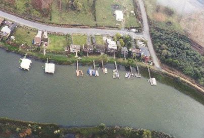
It is the house at the top of the picture. That is Piper Slough at the bottom of the picture. The houses along the levee are built up on pilling. The ground level is below sea level. There numerous housed built on the ground without pilling on the south end of Bethel Island. The people in those houses should be nervous about this destructive nature of Big Government!
Good Hunting... from Varmint Al
To: OXENinFLA
I just checked the flood zone using InterFlood. The FEMA panel is 0603370210D Zone "D" dated 8/2/1982. The map is titled "Floodscape".
I have no clue what type of flood hazard area "D" represents. I'm used to "A" and "B" being flood areas and "C" and "X" being non flood areas.
To: OXENinFLA
It's flooded with illegal aliens.
43 posted on
11/25/2003 2:47:17 PM PST by
tubavil
FreeRepublic.com is powered by software copyright 2000-2008 John Robinson