Skip to comments.
‘It’s a woman!’ Finder of potential Amelia Earhart pics on his discovery
Associated Press ^
| 7/7/2017
| Staff
Posted on 07/07/2017 4:18:46 AM PDT by simpson96
The retired federal agent who discovered what he believes is the first photographic evidence of Amelia Earhart alive and well after crash-landing in the Pacific Ocean during her attempted round-the-world flight says he didn’t initially capture the significance of the image until years later.
The black-and-white photo is of a group of people standing on a dock on Jaluit Atoll in the Marshall Islands, including one who seems to be a slim woman with her back to the camera. A new documentary airing Sunday on the History channel claims the figure is the famed aviator who disappeared 80 years ago this month.
Retired U.S. Treasury Agent Les Kinney said in an interview Wednesday with The Associated Press that he was looking for clues surrounding Earhart’s disappearance in the National Archives in College Park, Maryland, when he found the photograph in 2012 in a box filled mostly with text documents from the Office of Naval Intelligence but “didn’t really look at it carefully” because he was looking over thousands of documents and images.
In 2015, he took another pass at the photo. “I looked at it and I went, ‘I can’t believe this!'” He asked his wife to come over and pointed to the seated person, asking if it seemed to her to be a man or a woman. “She said, ‘It’s a woman!'” His search led him to identify the ship seen at the right apparently pulling Earhart’s plane wreckage on a barge. (snip) In the documentary, that photo is subjected to facial-recognition and other forensic testing, such as torso measurements. Experts on the show claim the subjects are likely Earhart and Noonan.
(Excerpt) Read more at nypost.com ...
TOPICS: Chit/Chat
KEYWORDS: brakingnews; pressrelease; publicitystunt; tvratings
Navigation: use the links below to view more comments.
first previous 1-20, 21-36 last
To: a fool in paradise
“It’s the back of someone’s head. Are they sure it isn’t Bela Lugosi’s chiropractor?”
LOL!!! Ed Wood lost his pearly whites taking this picture!
To: Yosemitest
Thanks for those links and info.
22
posted on
07/07/2017 6:29:24 AM PDT
by
Theoria
(I should never have surrendered. I should have fought until I was the last man alive)
To: outpostinmass2
It might be plausible but I don’t see the barge carrying a plane in the photo. The photo posted by E.L. is a cropped closeup to accentuate the people on the dock. The grey ship on the right is the Koshu, the same ship featured in the article posted by Yosemitist. In the original picture, there is an object that may be a plane towed behind the ship.
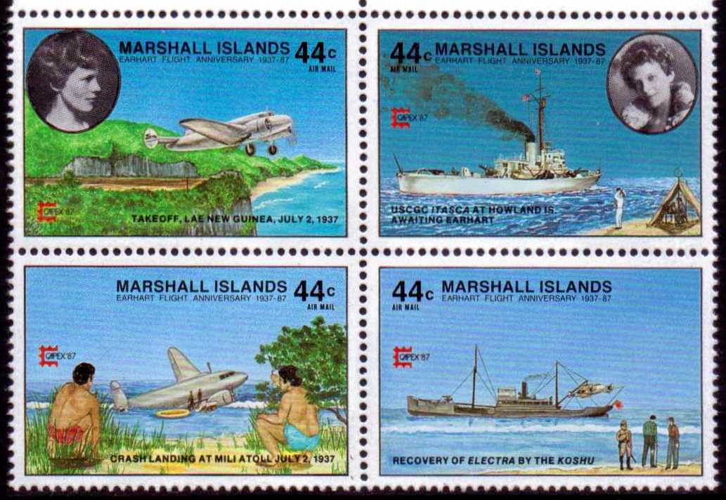
Koshu is also featured in a Marshall Islands stamp set about Amelia Earhart, issued years ago.
23
posted on
07/07/2017 7:28:28 AM PDT
by
Rinnwald
To: ROCKLOBSTER
If they had the technology to recover the plane, if they had the technology to take the picture, why didn't they have the technology to send her home?Japs didn't send those Americans perceived as spies home back then.
24
posted on
07/07/2017 7:48:12 AM PDT
by
JimRed
( TERM LIMITS, NOW! Building the Wall! TRUTH is the new HATE SPEECH.)
To: Texas Fossil
Earhart disappeared 16 years after the Titanic went down. By that time one would think wireless to be standard equipment aboard larger ships as shown in that photo. Would Earhart have kept mum under the circumstances, or would she instead have sought any way possible to communicate here whereabouts? Why not take a vessel back to safe harbor and then home?
To: Interesting Times; GreyFriar; SeraphimApprentice
Ping to an excellent Amelia Earhart thread.
26
posted on
07/07/2017 12:27:56 PM PDT
by
zot
To: zot; Interesting Times; SeraphimApprentice
The Daily Mail ran an article yesterday on the Amelia Earhart pictures. It reported that a different researcher had found them a year ago and he had determined that the photos were taken in 1940, not 1937.
Here is that link: http://www.dailymail.co.uk/news/article-4670468/Photo-showing-Amelia-Earhart-NOT-aviator.html
I continue to go with the theory that Earhart and Noonan crash landed on Jaluit Island as written in: “The Search for Amelia Earhart” by Fred Goerner
27
posted on
07/07/2017 1:12:48 PM PDT
by
GreyFriar
(Spearhead - 3rd Armored Division 75-78 & 83-87)
To: zot; Interesting Times; SeraphimApprentice
The Daily Mail ran an article yesterday on the Amelia Earhart pictures. It reported that a different researcher had found them a year ago and he had determined that the photos were taken in 1940, not 1937.
Here is that link: http://www.dailymail.co.uk/news/article-4670468/Photo-showing-Amelia-Earhart-NOT-aviator.html
I continue to go with the theory that Earhart and Noonan crash landed on Jaluit Island as written in: “The Search for Amelia Earhart” by Fred Goerner
28
posted on
07/07/2017 1:12:58 PM PDT
by
GreyFriar
(Spearhead - 3rd Armored Division 75-78 & 83-87)
To: GreyFriar
Whoops, sorry for double post.
29
posted on
07/07/2017 1:15:47 PM PDT
by
GreyFriar
(Spearhead - 3rd Armored Division 75-78 & 83-87)
To: GreyFriar
The Daily Mail article doesn’t prove or disprove anything. I’m not sure about the recently discovered photo, but I am impressed by the Marshall Islands 50th anniversary stamp that is labeled “Recovery of the Electra by the Koshu.”
30
posted on
07/07/2017 4:36:32 PM PDT
by
zot
To: Fester Chugabrew
I simply don’t believe the ship in the picture has anything to do with Erhart’s crash site.
I’ve been to her home town many times. Worked for an old family who ran a distribution business there.
There are lots of efforts to piece the crash together. Her plane did have a radio, trailing wire operation. She had a radio operator on board too.
Here are some records related:
https://tighar.org/wiki/Transmissions_heard_from_NR16020
Sounds like they used a mixture of AM phone and CW transmissions. That was the extent of the equipment of the day. AM phone is not good for weak signal conditions. CW is usually much much better, with weak signals.
Distance between stations and time of day makes a huge difference on High Frequency signals. (HF is not very high now.) They were operating using 3.1 mhz and 6.2 mhz frequencies.
31
posted on
07/07/2017 7:46:10 PM PDT
by
Texas Fossil
((Texas is not where you were born, but a Free State of Heart, Mind & Attitude!))
To: zot
32
posted on
07/08/2017 4:57:51 AM PDT
by
GreyFriar
(Spearhead - 3rd Armored Division 75-78 & 83-87)
To: Texas Fossil
you posted: “She had a radio operator on board too.” are you referring to her navigator, Fred Noonan, or an unknown 3d person on the flight? From all I’ve read, over the decades, she alone operated the radios from the cockpit. Noonan was separated from her in the rear of the plane. There were also reports that she had left the trailing antenna at Lae Field because of its weight and the length of the flight to Howland Island.
33
posted on
07/08/2017 5:03:04 AM PDT
by
GreyFriar
(Spearhead - 3rd Armored Division 75-78 & 83-87)
To: Theoria
Here's the problem.
There are 2 DIFFERENT ATOLLS in question and back during World War II, from the sea, or from the air at low level, it wold be easy to confuse them.
Also, if the two governments did NOT want the evidence found of their spying, or their lies, they might intentionally confuse the two different Atolls to hid the evidence.
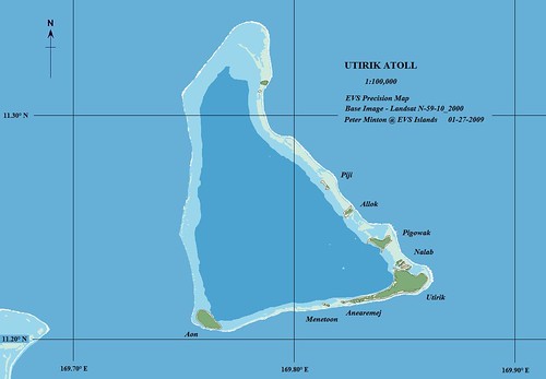
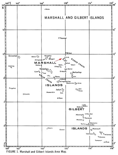 Now there is a big distance between the Utirik Atoll, and the Chirubon Island on Mili Atoll
 Look at the map of the Marshall and Gilbert Islands, and the red arrow is pointing to the
Utirik Atoll.
But the Mili Atoll and the Knox Atoll are down one block and to the right one block, about 6 degrees North and 172 degrees East.
That's roughly 400 miles between the two different Atolls.
Utirik Atoll is North-North-West of Mili Atoll.
I call my friends and asked them again about the aircraft wreckage they dived on.
They said:
It was on THE NORTH END of Utirik Atoll, or Chirubon Island, of Mili Atoll.
Most of the wreckage was in the tree line, and on the beach, and it was part of one wing and a piece of the tail.
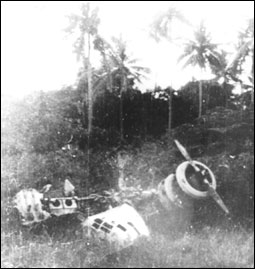
Pieces were in the water between the island and the coral reef.
Local Utirik Island people said the Japanese towed the aircraft beyond the reef and told them they would sink it.
My friends said they did not see any large pieces of the aircraft beyond the reef.
Now, here's another problem.
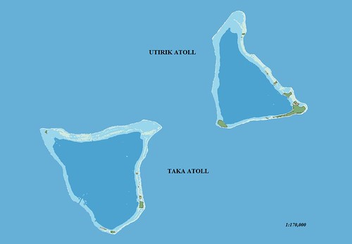
Utirik Atoll (also Utrik or Utrōk) and Taka Atoll were used as nuclear test sites during WWII.
What better way to secure an area from being searched is there ?
But my friends said
there's enough wreckage on the tree line and on shore ... that they took photos, during the mid 1980s, and sent them to the University of Michigan for identification.
The University of Michigan wrote them that it was an Electra type aircraft, but there were no serial numbers that could positively identify that wreckage as Amelia Earhart's Electra.
Even though that was over 30 years ago, I feel sure that someone could go back to
THE NORTH END of Utirik Atoll or
THE NORTH END of Chirubon Island on Mili Atoll and find that wreckage.
Now consider
A compilation of radio messages and eyewitness sightings of Amelia Earhart and Fred Noonan in the Marshall Islands and on the island of Saipan using Noonan's injuries as a common thread.
“On July 3rd, 1937 at 2:20 PM EST, I picked up Amelia Earhart's distress signal by short wave.
This message contained some 300 to 400 words-in which she described Mille or Mulgrave atoll, Klee Passage, Knox island and seemed to be located on a small island of 133 acres adjoining Knox, directly NE of a part of Marshall Island”.
That would be Chirubon island, just to the north of Knox .
On the 5th of July. Nina picked up an SOS giving 177 longitude.... and 58 minutes above the equator.
The radio was fading in and out so the coordinates were partial.
Just for fun, I took those numbers, bought aerial navigation charts from NOAA, and inserted all of the possible number combinations for coordinates in the Marshall Islands to make a complete set of coordinates.
The only place in the Marshalls that I came close to land were the coordinates-172.07 degrees east, 5 hours and 58 minutes north of the equator,
the reef plain on the western shore of Chirubon Island.
That area is dry at low tide and has about 5 feet of water at high tide.
Several years later I received a copy of Charles N. Hill's book “Fix on the Rising Sun” and noted that his redo of the LOP (line of position), page 140, puts the LOP a few miles east of this location."
BUT I THINK THIS "A compilation of radio messages and eyewitness sightings" IS LEADING PEOPLE TO THE WRONG ATOLL !
I THINK ... INSTEAD ... THAT ...
I hope this helps someone verify the wreckage.
BUT ...
If you’re looking for
Barre Island.

Compare to NorthWestern portion of the map below.

34
posted on
07/08/2017 6:00:56 AM PDT
by
Yosemitest
(It's SIMPLE ! ... Fight, ... or Die !)
To: Yosemitest
I visited Kwajalein over Christmas. My gf was stationed there at the time. Interesting place. And some of the locals talked of seeing ‘her’ there[local lore].
35
posted on
07/08/2017 10:12:30 AM PDT
by
Theoria
(I should never have surrendered. I should have fought until I was the last man alive)
To: Theoria
Watch this:
Also the History Channel has this show if you can catch it.

AMELIA EARHART: THE LOST EVIDENCE WATCH THE FULL SPECIAL
Former FBI official Shawn Henry investigates new, shocking evidence that aviator Amelia Earhart was captured by the Japanese military, including a photograph that purports to show Earhart and navigator Fred Noonan alive after their disappearance. Evidence includes documents containing new information indicating that the U.S. government knew that she was in the custody of a foreign power, and may have covered it up.
36
posted on
07/13/2017 10:54:56 AM PDT
by
Yosemitest
(It's SIMPLE ! ... Fight, ... or Die !)
Navigation: use the links below to view more comments.
first previous 1-20, 21-36 last
Disclaimer:
Opinions posted on Free Republic are those of the individual
posters and do not necessarily represent the opinion of Free Republic or its
management. All materials posted herein are protected by copyright law and the
exemption for fair use of copyrighted works.
FreeRepublic.com is powered by software copyright 2000-2008 John Robinson


