Posted on 09/18/2015 7:04:15 PM PDT by Citizen Zed
The Climate Prediction Center Thursday released its late fall / early winter forecast for the United States. This forecast includes the months of October, November and December.
Graphics show Western New York is forecast to have a warmer, and drier than normal, period during these three months. This seems to follow what can be typically expected during an El Nino event.
During strong El Nino events like this year, warm waters in the tropical Pacific ocean cause a strengthening of the Pacific jet stream which tends keep cold air bottled up in Canada and an active strorm track across the Southern US. Such a pattern is a warm one for Western New York during the winter and diminishes the lake effect snow process which keeps our seasonal snow totals down.
There are reasons to believe, however that this is not a typical strong El Nino. There have been many comparisons of this event to the past strong El Ninos of 1997 and 1982. The winters of those years were a bit warmer and drier than average here, but the El Nino we are watching develop this year is different.
First, the pool of warm water is much father west than what is typical, and the entire Northern Pacific ocean is also running much warmer than normal. This is in contrast to the set-ups of 1997 and 1982. This can have a dramatic effect on how the jet stream eventually sets up resulting in the possibility of more cold air intrusions than one would typically expect in an El Nino winter.
On the other side of the US, the Atlantic ocean is running cooler than normal, again in opposition to the set-up of those two previous strong El Nino winters. 2 On Your Side Meteorologist Patrick Hammer says he believes we can not yet lock into a warm and dry winter just yet.
There are many local effects we need to look at as well. A warmer winter could keep Lake Erie from freezing over, which could imply more snow as any lake effect season would last longer into the winter. ( A frozen Lake Erie shuts that process down). Also, even if we do not have an active lake effect snow season, a strong Pacific jet stream can lead to larger winter storm development across the East Coast that could stretch into Western NY.
It is growing more and more likely our upcoming winter will not be as hash as our past two winters, but it will be very interesting to see how this winter will unfold given how different the lead-in to the season is looking compared to past El Nino events. Hammer says there is one year that does look similar to this year in terms of how ocean temperature distribution is set up during the fall. That year was 1958, and that winter brought heaps of snow.
They can’t accurately predict the weather 10 days out and now they are predicting it months in advance?
They still can’t correctly predict tomorrow’s weather. Why does anyone pay attention to these “long range weather outlooks”?
They are part of the next Water Year.
I predict that G_d’s sense of humor will kick in and make all these predictions null and void. Much like all the snowstorms that seem to occur in any city the global warming crowd throws a shindig.
Pointless prognosticating for the Finger Lakes Region...
Yes. Winter begins on Dec. 21. As to what kind of winter we’re going to have..... I venture a guess and say.. cold!.
Name me, ping me...
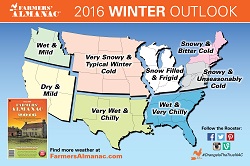
what does the Farmer’s Almanac say?
Hell here in SoCal they can't even get the next day right. For the last ten days every prediction has been off temp wise, always predicting 5-10 degrees cooler than what we get.

This guy must listen to Joe Bastardi who will be posted here tomorrow. Joe has been saying this is more like the 57-58 El Nino versus the 97 El Nino everyone else has been pushing. Joe is way ahead of the curve.
We go by the Farmer’s Almanac which is predicting another cold winter just like last year. I think they are supposed to be right about 80% of the time. :-)
IOW, they just don’t know and they’re using a lot of words to say so and yet sound intelligent and like they know what they’re talking about.
I’d love to see a nice Indian summer through Nov this year, we’re due. Been pretty nice so far. I’d rather not blow through 14 cord of wood again this year, last winter sucked.
It is sometimes easier to predict a general seasonal trend in certain geographic areas (like the Pacific Northwest where I am) than a given day next week. The developing El Nino is a good example of that.
As I read it, they’re covered whichever way it turns out.
That’s what I read, too. Either warmer than normal or colder than normal; either wetter than normal or drier than normal. Maybe all the two-handed economists got tired of being wrong all the time and switched to meteorology.
Bookmark - we’ll see...
If they do so say themselves, but accuracy should presuppose a degree of precision, http://news.psu.edu/story/141165/2007/09/24/research/probing-question-farmers-almanac-accurate >
John Walsh, University of Illinois Atmospheric Sciences professor emeritus, reviewed the accuracy of five years of monthly forecasts from 32 weather stations around the county and found 50.7% of the monthly temperature forecasts and 51.9% of precipitation forecasts to correctly predict a deviation from averages.[32][33] https://en.wikipedia.org/wiki/Old_Farmer's_Almanac#Accuracy
Disclaimer: Opinions posted on Free Republic are those of the individual posters and do not necessarily represent the opinion of Free Republic or its management. All materials posted herein are protected by copyright law and the exemption for fair use of copyrighted works.