Posted on 06/10/2009 8:24:28 AM PDT by CodeToad
Narrative: An Air France Airbus A330-200 was destroyed when it crashed into the sea while on transatlantic flight from Rio de Janeiro-Galeao International Airport, RJ (GIG) to Paris-Charles de Gaulle Airport. The airplane carried 12 crew members an 216 passengers. Flight AF447 departed at 19:03 local time (May 31) from Rio de Janeiro (GIG). Last radio contact with the flight was at 01:33 UTC. The crew was in contact with the Atlantic Area Control Centre (CINDACTA III) when the flight reported over the INTOL waypoint, estimating TASIL at 02:20 UTC. INTOL is an RNAV waypoint located in the Atlantic Ocean, 565 km from Natal, Brazil. The TASIL waypoint is located 1228 kilometers from Natal. TASIL is at the border of the Recife FIR and Dakar Oceanic FIR.
...
Aviation Safety Network: Accident Description
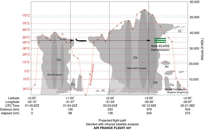
Air France Flight 447: A detailed meteorological analysis / by Tim Vasquez
Here are a few example charts given in the analysis.
Example Chart: Cross-Section of Winds Aloft and Flight Path
Example Chart: Top of Clouds and Flight Path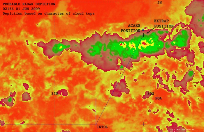
(Excerpt) Read more at aviation-safety.net ...
Very interesting.
It kinda scares me the way the media grabs something and runs with it before all the facts are in ... then people jump on that and make all sorts of speculation ... I like to wait and see what kicks loose on all this ... there’s more than meets the eye on all this ...
I thought the response of pilots that have experienced flying around tropical storms was the most interesting part of weather graphics site.
School is over, but am working on letters I need to get out for my Youth In College class. Things should slow down soon.
Listening to Rush online as I work.
Whoops... the post # 2 provided the feedback was what I was reading earlier.
Disclaimer: Opinions posted on Free Republic are those of the individual posters and do not necessarily represent the opinion of Free Republic or its management. All materials posted herein are protected by copyright law and the exemption for fair use of copyrighted works.