
Posted on 08/25/2008 8:27:52 AM PDT by NautiNurse
Tropical Depression 7 has formed in the eastern Caribbean.
Buoy Data:
East Caribbean Buoys
West Caribbean Buoys
Florida Buoys
| Category | Wind Speed | Barometric Pressure | Storm Surge | Damage Potential |
|---|---|---|---|---|
| Tropical Depression |
< 39 mph < 34 kts |
Minimal | ||
| Tropical Storm |
39 - 73 mph 34 - 63 kts |
Minimal | ||
| Hurricane 1 (Weak) |
74 - 95 mph 64 - 82 kts |
28.94" or more 980.02 mb or more |
4.0' - 5.0' 1.2 m - 1.5 m |
Minimal damage to vegetation |
| Hurricane 2 (Moderate) |
96 - 110 mph 83 - 95 kts |
28.50" - 28.93" 965.12 mb - 979.68 mb |
6.0' - 8.0' 1.8 m - 2.4 m |
Moderate damage to houses |
| Hurricane 3 (Strong) |
111 - 130 mph 96 - 112 kts |
27.91" - 28.49" 945.14 mb - 964.78 mb |
9.0' - 12.0' 2.7 m - 3.7 m |
Extensive damage to small buildings |
| Hurricane 4 (Very strong) |
131 - 155 mph 113 - 135 kts |
27.17" - 27.90" 920.08 mb - 944.80 mb |
13.0' - 18.0' 3.9 m - 5.5 m |
Extreme structural damage |
| Hurricane 5 (Devastating) |
Greater than 155 mph Greater than 135 kts |
Less than 27.17" Less than 920.08 mb |
Greater than 18.0' Greater than 5.5m |
Catastrophic building failures possible |
We’ll have to see about that. Corrine’s actions showed complete disregard for her neighbor’s/constituent’s plight during a very stressful time in their lives. Then again, Ray Nagin was re-elected. You are probably right.
Tropical Storm Public Advisory
Statement as of 5:00 PM EDT on August 26, 2008
...Gustav moving over the southwestern peninsula of Haiti...expected
to be near eastern Cuba tomorrow...
A Hurricane Warning remains in effect from Barahona in the Dominican
Republic westward to Le Mole St Nicholas Haiti.
A Hurricane Warning is in effect for Cuba for the provinces of
Guantanamo...Santiago de Cuba...and Granma. A Hurricane Warning
means that hurricane conditions are expected within the warning
area...generally within 24 hours.
A Hurricane Watch remains in effect for Haiti from Le Mole St
Nicholas to the northern Haiti/Dominican Republic border.
A Hurricane Watch remains in effect for the Cuban provinces of Las
Tunas and Holguin. A Hurricane Watch is also in effect for Jamaica.
A Hurricane Watch means that hurricane conditions are possible
within the watch area...generally within 36 hours.
Interests in central and western Cuba and the Cayman Islands should
closely monitor the progress of Gustav.
For storm information specific to your area...including possible
inland watches and warnings...please monitor products issued
by your local weather office.
At 500 PM EDT...2100z...the center of Hurricane Gustav was located
near latitude 18.4 north...longitude 73.2 west or about 60 miles...
95 km...west-southwest of Port au Prince Haiti and about 180 miles
...290 km...southeast of Guantanamo Cuba.
Gustav is moving toward the northwest near 10 mph...17 km/hr.
A turn toward the west-northwest with a decrease in forward speed
is expected tonight...and a general west-northwestward
motion is expected on Wednesday. On this track the hurricane should
move back over water to the north of the southwestern peninsula of
Haiti tonight and move near or just south of eastern Cuba on
Wednesday.
Maximum sustained winds have decreased to near 75 mph...120
km/hr...with higher gusts. Gustav is a category one hurricane on
the Saffir-Simpson scale. Some additional weakening is likely
while the center is over land...but restrengthening is forecast to
begin when the center moves back over water tonight or early
Wednesday.
Hurricane force winds extend outward up to 15 miles...30 km...from
the center...and tropical storm force winds extend outward up to 70
miles...110 km.
The estimated minimum central pressure is 992 mb...29.29 inches.
Gustav is expected to produce total rainfall accumulations of 4 to 8
inches over Hispaniola...eastern Cuba...and Jamaica...with isolated
maximum amounts of up to 20 inches possible. These rains will
likely produce life-threatening flash floods and mud slides.
Coastal storm surge flooding of 2 to 4 feet above normal tide levels
along with large and dangerous battering waves can be expected in
areas of onshore winds in the Hurricane Warning area.
Repeating the 500 PM EDT position...18.4 N...73.2 W. Movement
toward...northwest near 10 mph. Maximum sustained winds...75 mph.
Minimum central pressure...992 mb.
An intermediate advisory will be issued by the National Hurricane
Center at 800 PM EDT followed by the next complete advisory at 1100
PM EDT.
$$
Forecaster Pasch
Hurricane Gustav Discussion Number 7
Statement as of 5:00 PM EDT on August 26, 2008
Air Force hurricane hunter reports and visible satellite images...on
which the eye of the hurricane became evident...indicate that the
center of Gustav made landfall around 1730 UTC. A minimum pressure
of 992 mb was reported by the aircraft just as the center moved
inland...however a dropsonde released just east of the eye had a
surface pressure of 997 mb with southerly winds of 64 kt. So the
central pressure may have been somewhat lower than 992 mb. In any
event...now that the center is moving over the mountainous terrain
of the southwest peninsula of Haiti...Gustav is likely losing
strength. The eye is no longer evident on satellite images...and
the system could weaken below hurricane intensity tonight. However
the upper-level environment remains favorable for intensification
with only a little north-northeasterly shear...and therefore Gustav
is likely to regain strength as it approaches the Windward Passage
and eastern Cuba tomorrow. The official intensity forecast is a
blend of the SHIPS...lgem...HWRF...and GFDL guidance and is very
similar to the previous NHC wind speed forecast. It should be
recalled that both subjective and model forecasts of intensity have
little skill in the 3- to 5-day range.
Initial motion is around 305/9. The main player in the steering
pattern for Gustav continues to be a mid-tropospheric
anticyclone/high centered near the Florida Peninsula. The tropical
cyclone’s heading should gradually Bend toward the left as it moves
along the southern periphery of this anticyclone. Later in the
forecast period...Gustav is expected to turn toward the northwest
as it rounds the southwestern periphery of the high. The track
guidance models are in pretty good agreement on a gradual turn
toward the west-northwest over the next day or so...and overall the
model consensus has changed little from the previous advisory
package. Therefore the track forecast for this advisory is
essentially an extension of the previous one.
Forecast positions and Max winds
initial 26/2100z 18.4n 73.2w 65 kt
12hr VT 27/0600z 18.9n 74.0w 75 kt
24hr VT 27/1800z 19.3n 75.2w 80 kt
36hr VT 28/0600z 19.5n 76.6w 85 kt
48hr VT 28/1800z 19.6n 78.0w 90 kt
72hr VT 29/1800z 20.3n 81.0w 100 kt
96hr VT 30/1800z 22.5n 85.0w 105 kt
120hr VT 31/1800z 25.5n 88.5w 105 kt
$$
forecaster Pasch
Didn't mean to be disrespect and rude. Apologies. However, I consider living in a subtropical environment with a non-concrete reinforced home to be pretty foolish. Almost everything you have collected (material goods) for your life are located in your house. Not preparing for a known LIKELY disaster is kind of foolish. Stupid was the wrong word to use.
I hope it heads straight for Fidel and Raul Castro’s houses.
Nope, but I would mandate that homes used concrete and rebar to survive the winds.
Do tell us, is your home built to withstand an F5 tornado? You are, after all, living in Texas.
This isn’t really the thread to bash people living along the coast lines or in the path of Hurricanes it is more of an informational thread.
But if you insist on this type of behavior feel free.
I heard on Houston Talk Radio (KSEV) awhile ago that this storm is tracking very similiar to the Great Hurricane of 1900 which wiped out Galveston and is to this day the greatest national disaster in the history of the U.S.
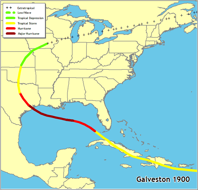
1900 Great Galveston Hurricane
Oh dear.
Click here and scroll halfway down or so.
Note to Congress: Alaska doesn't get hurricanes.
Over 91 pct of normal daily crude oil production in the Gulf --
1.5 mln barrels -- is now shut down, and more than 83 pct of
natural gas production, the MMS said. [Aug. 31, 2005]
Where do you “smart” people live?
The loop situation is very similar to 2005 this year. I am pretty sure that the warmest part is further south than it was that year though, which is probably a good thing — though the GOM can really sustain a big storm just about anywhere if it moves in right.
I think the biggest concern is if it heads toward Texas, which I also feel is the most likely current scenario. Highest heat content in the GOM is lined up in that direction more or less.. and if it’s heading west it’s unlikely being disrupted as much by shear.
http://www.coaps.fsu.edu/~maue/extreme/gfdl/gustav07l.2008082618/gustav07l.2008082618_anim.html
Not for the faint of heart.
Yowser—916 mb. I’ve got that sick feeling in my stomach again.
Tropical Storm Public Advisory
Statement as of 8:00 PM EDT on August 26, 2008
...Gustav still a hurricane over southern Haiti...
...Heavy rainfall continues across most of Hispaniola...
at 8 PM EDT...0000z...the government of the Cayman Islands has
issued a Hurricane Watch for all of the Cayman Islands.
At 8 PM EDT...the government of the Dominican Republic has
discontinued the Hurricane Warning for all of the Dominican
Republic.
A Hurricane Warning remains in effect for Cuba for the provinces of
Guantanamo...Santiago de Cuba...and Granma. A Hurricane Warning
means that hurricane conditions are expected within the warning
area...generally within 24 hours.
A Hurricane Watch remains in effect for Haiti from Le Mole St
Nicholas to the northern Haiti/Dominican Republic border.
A Hurricane Watch remains in effect for the Cuban provinces of Las
Tunas and Holguin. A Hurricane Watch is also in effect for Jamaica.
A Hurricane Watch means that hurricane conditions are possible
within the watch area...generally within 36 hours.
Interests in central and western Cuba and the Cayman Islands should
closely monitor the progress of Gustav.
For storm information specific to your area...including possible
inland watches and warnings...please monitor products issued
by your local weather office.
At 800 PM EDT...0000z...the center of Hurricane Gustav was
located...based on images from the radar at gran Piedra Cuba...to
be near latitude 18.5 north...longitude 73.3 west or about 60
miles...100 km...west of Port au Prince Haiti and about 155
miles...250 km...southeast of Guantanamo Cuba.
Gustav is moving toward the northwest near 7 mph...11 km/hr. A turn
toward the west-northwest is expected later tonight...and a general
west-northwestward motion is expected on Wednesday. On this
track...Hurricane Gustav should pass near the southwestern
peninsula of Haiti tonight and move near or just south of eastern
Cuba on Wednesday.
Maximum sustained winds remain near 75 mph...120 km/hr...with higher
gusts. Gustav is moving back over water and is still a category one
hurricane on the Saffir-Simpson scale. Some fluctuations in
strength are possible tonight as Gustav interacts with land...but
restrengthening is forecast to begin when the center emerges over
the Windward Passage on Wednesday.
Hurricane force winds extend outward up to 15 miles...30 km...from
the center...and tropical storm force winds extend outward up to 70
miles...110 km.
The estimated minimum central pressure is 992 mb...29.29 inches.
Gustav is expected to produce total rainfall accumulations of 4 to 8
inches over Hispaniola...eastern Cuba...and Jamaica...with isolated
maximum amounts of up to 20 inches possible. These rains will
likely produce life-threatening flash floods and mud slides.
Coastal storm surge flooding of 2 to 4 feet above normal tide levels
along with large and dangerous battering waves can be expected in
areas of onshore winds in the Hurricane Warning area.
Repeating the 800 PM EDT position...18.5 N...73.3 W. Movement
toward...northwest near 7 mph. Maximum sustained winds...75 mph.
Minimum central pressure...992 mb.
The next advisory will be issued by the National
Hurricane Center at 1100 PM EDT.
$$
Forecaster Stewart/Franklin
I thought it was because you didn't know when you might get power & water back afterwards...better wash everything you might want to wash for a few weeks while you still can...
Disclaimer: Opinions posted on Free Republic are those of the individual posters and do not necessarily represent the opinion of Free Republic or its management. All materials posted herein are protected by copyright law and the exemption for fair use of copyrighted works.