Skip to comments.
Geology Picture of the Week, November 19-25, 2006: Mask Rock and Turkey Rock(s)
Natural Arch and Bridge Society ^
| Various
Posted on 11/20/2006 1:14:02 PM PST by cogitator
Mining the Natural Arch and Bridge Society site for fun found this:
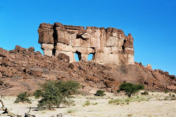
"Mask Rock is located in the Ouadi Archei region of Ennedi [Chad] about 39 kilometers SSE of Fada. The left opening has a span of 36 feet and a height of 57 feet. The right opening has a span of 27 feet and a height of 50 feet. Photo by Gunter Welz."
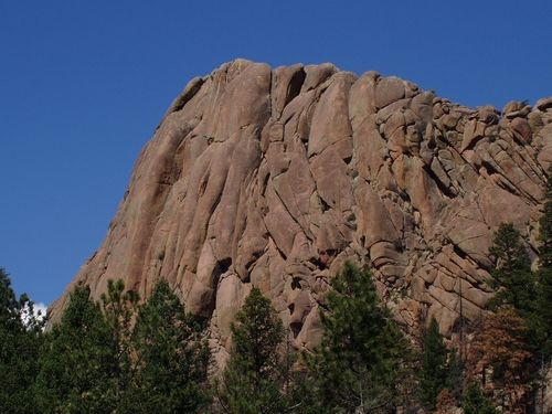
Just for the heck of it, Googling on "Turkey Rock" discovered this, apparently somewhere around Aspen (Independence Pass, wherever that is):

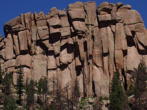
Another Web site, mostly written in Czechoslovakian, calls the images below Turkey Rock and Turkey Tail, and indicates that they're in the South Platte region of Colorado (apparently near Woodland Park and Elevenmile Canyon).
Turkey Rock
Turkey Tail
TOPICS: Arts/Photography; Outdoors; Science; Travel
KEYWORDS: arches; dunes; sand; sandstone
Navigation: use the links below to view more comments.
first 1-20, 21-28 next last
Maybe Mask Rock was more appropriate for Halloween than Thanksgiving!
1
posted on
11/20/2006 1:14:07 PM PST
by
cogitator
To: 2Trievers; headsonpikes; Pokey78; Lil'freeper; epsjr; sauropod; kayak; Miss Marple; CPT Clay; ...
2
posted on
11/20/2006 1:15:29 PM PST
by
cogitator
To: cogitator

Turkey Peak, Enchanted Rock, Texas
3
posted on
11/20/2006 1:24:58 PM PST
by
lormand
(Weinerism is a mental disorder)
To: lormand
Stone Mountain (Atlanta, GA) and its near-brothers (but more tree covered, and so less impressive): Kennesaw Mountain, GA, Lost Mountain GA, Pine Mountain, GA.
All lava upthrusts of weathered rock above a relatively flat plain around them.
4
posted on
11/20/2006 1:36:57 PM PST
by
Robert A Cook PE
(I can only donate monthly, but Hillary's ABBCNNBCBS continue to lie every day!)
To: Robert A. Cook, PE
5
posted on
11/20/2006 1:40:45 PM PST
by
editor-surveyor
(Atheist and Fool are synonyms; Evolution is where fools hide from the sunrise)
To: Robert A. Cook, PE
I want to see Stone Mountain one day.
Enchanted Rock is about 1 hour drive from here, and I visit it as often as I can. There are lots of geological points of interest there. There is one particular outcrop at Enchanted Rock that is quartz. The trails around it sparkle brightly in the sun.
6
posted on
11/20/2006 1:42:40 PM PST
by
lormand
(Weinerism is a mental disorder)
To: lormand
I just went to Stone Mountain...via Google Earth that is. Pretty incredible view. Check it out...it's a free download.
7
posted on
11/20/2006 2:07:35 PM PST
by
Dark Skies
("He who knows only his own side of the case knows little of that" ... John Stuart Mill)
To: Dark Skies
Yes, I like the view on Google Earth. I noticed a station or lodge of some sort on top of Stone Mountain.
8
posted on
11/20/2006 2:15:53 PM PST
by
lormand
(Weinerism is a mental disorder)
To: lormand
I think it's a station. It's been 10 years since I've been there in person.
BTW, I have located the pyramids at Giza (just go west of Giza to the edge of the desert) and even Hitler's house at Eagles Nest. Google Earth is pretty darned incredible for virtual travel.
9
posted on
11/20/2006 2:29:55 PM PST
by
Dark Skies
("He who knows only his own side of the case knows little of that" ... John Stuart Mill)
To: lormand
FYI, Wikipedia often has the latitude and longitude of landmarks etc and that's a big help in locating the sights from satellite.
10
posted on
11/20/2006 2:41:21 PM PST
by
Dark Skies
("He who knows only his own side of the case knows little of that" ... John Stuart Mill)
To: editor-surveyor
11
posted on
11/20/2006 2:55:14 PM PST
by
Robert A Cook PE
(I can only donate monthly, but Hillary's ABBCNNBCBS continue to lie every day!)
To: lormand
Aerial photograph of Stone Mountain (1/2 size, click it for full-size):

To: lormand
That is a museum and snackbar on top of Stone Mountain. It is a really beautiful place to visit, and we have picnics there every year.
13
posted on
11/21/2006 8:24:54 AM PST
by
geezerwheezer
(get up boys, we're burnin' daylight!!!)
To: Dark Skies
One of my favorite Google Earth sites is the Bone Yard near Tempe Arizona.
You can easily see the different planes they have stored there, like the B-52s, F-4s, F-111s etc.
14
posted on
11/21/2006 8:27:46 AM PST
by
lormand
(Weinerism is a mental disorder)
To: lormand
Do you have the longitude and latitude for the bone yard.
BTY, check out Area 51 and Groom Lake.
15
posted on
11/21/2006 8:51:30 AM PST
by
Dark Skies
("He who knows only his own side of the case knows little of that" ... John Stuart Mill)
To: Dark Skies
Bone Yard
32 09'59.10" N
110 51'43.41" W
Looking for area 51 now...near Roswell NM right?
16
posted on
11/21/2006 8:56:06 AM PST
by
lormand
(Weinerism is a mental disorder)
To: lormand
Area 51/Groom Lake is at 37 14' 17N and 115 48' 30W
17
posted on
11/21/2006 8:59:53 AM PST
by
Dark Skies
("He who knows only his own side of the case knows little of that" ... John Stuart Mill)
To: Dark Skies
18
posted on
11/21/2006 9:05:30 AM PST
by
lormand
(Weinerism is a mental disorder)
To: Dark Skies
Thanks, I thought Area 51 was near Roswell NM.
19
posted on
11/21/2006 9:08:40 AM PST
by
lormand
(Weinerism is a mental disorder)
To: lormand
I just visited the Boneyard...incredible!
20
posted on
11/21/2006 9:11:56 AM PST
by
Dark Skies
("He who knows only his own side of the case knows little of that" ... John Stuart Mill)
Navigation: use the links below to view more comments.
first 1-20, 21-28 next last
Disclaimer:
Opinions posted on Free Republic are those of the individual
posters and do not necessarily represent the opinion of Free Republic or its
management. All materials posted herein are protected by copyright law and the
exemption for fair use of copyrighted works.
FreeRepublic.com is powered by software copyright 2000-2008 John Robinson