Posted on 12/09/2023 7:05:46 PM PST by davikkm
https://twitter.com/_/status/1733577260714922296 https://twitter.com/_/status/1733579163356008603
Mesoscale Discussion 2305 NWS Storm Prediction Center Norman OK 0159 PM CST Sat Dec 09 2023
Areas affected...Western/central KY...Western/middle TN...Northwest MS...Eastern AR...Northwest AL
Concerning...Tornado Watch 714...
https://www.spc.noaa.gov/products/md/md2305.html
Valid 091959Z - 092130Z
The severe weather threat for Tornado Watch 714 continues.
SUMMARY...The threat for a few tornadoes and isolated severe wind/hail will continue through the afternoon, with storm coverage expected to increase with time.
DISCUSSION...A broken line of supercells is ongoing early this afternoon from western TN into eastern AR, with occasional rotating cells noted within a larger storm cluster across western KY. A supercell cluster currently approaching the TN/KY border produced an earlier apparent tornado in northwest TN, with another tornado recently noted just southwest of the KHPX radar. The other cells along the broken line will continue to pose a threat of all severe hazards as they move east-northeastward. These cells are ongoing along and just ahead of a composite outflow boundary/cold front that will continue to move eastward this afternoon. Deep-layer flow parallel to the boundary may encourage an increase in storm coverage and a transition to more of a mixed mode with time, though embedded supercells will likely continue to be possible through the afternoon, with all severe hazards possible.
The greatest short-term tornado threat (including the potential for a strong tornado) will likely continue to be focused from far northwest MS into western/middle TN, southern KY, and eventually extreme northwest AL, where the most favorable overlap of low-level/deep-layer shear (including 0-1 km SRH of 150-250 m2/s2 noted on regional VWPs and objective mesoanalyses) and instability (MLCAPE of 1000-1500 J/kg) will persist this afternoon, prior to the arrival of the front. This area is being upgraded to an Enhanced Risk (driven by 10% tornado probabilities) in the upcoming 20Z outlook.
(Excerpt) Read more at citizenwatchreport.com ...
The abbreviation for the State of Kentucky is KY, not KT. Who writes these headlines. Internet garbage by illiterates.
Video
Large intense Tornado Nashville TN
https://rumble.com/v40i2p1-large-intense-tornado-nashville-tn.html?playlist_id=G5SoGtm7-QQ
Video
Tornado hitting Clarksville TN Dec 9, 2033
https://rumble.com/v40i3qs-tornado-hitting-clarksville-tn-dec-9-2033.html
Video
Tornado causing explosions near Nashville
https://rumble.com/v40i63s-tornado-causing-explosions-near-nashville.html
Another Clarksville video
Dec 9, 2023 Clarksville TN tornado
https://rumble.com/v40iep4-dec-9-2023-clarksville-tn-tornado.html
Video Springfield, TN Tornado Dec 9, 2023
https://rumble.com/v40ih1j-springfield-tn-tornado-dec-9-2023.html
Sweeping storm! Storms did that during the summer a few times
Severe weather!
Coal plants & SUV’s hit hardest.
That line isn’t one I’ve ever seen. Odd.
Oh we’ll never hear the end of this from the climate activists now.
It may not seem like it to them, but they have everything that is really important - themselves and the children. The cars are a bonus. Everything else can be replaced, or remembered.
Just east of Meridian @ a Truck.Stop for thw night, traveling from Bowling Green, KY. 5th wheel is starting to rock a bit, sirens blaring, bad stuff is south.
What happened to all the doomsday machines of 20/30 years ago about cloud salting (or whatever) ?
i saw a video of the tornado in Nashville, Tennessee tonight...there was a huge explosion and fireball...never seen anything like that before. Anybody know what it hit??....oddest thing i ever saw, the fireball was literally sucked right up into the twister....
I’m in South Central Kentucky. Wet a little bit of thunder this evening. That really bad tornado a while back missed our house by less than a quarter of a mile. They really do sound like a freight train.
Some even cause me to jump. Mainly because we took a direct lightening hit Friday night, a week ago, that took out my internet, the built-in microwave, a Bose wave radio that I have had for decades, as well as, some lights that we just got restored, thank goodness. One of the hazards of living in Louisiana. 😋
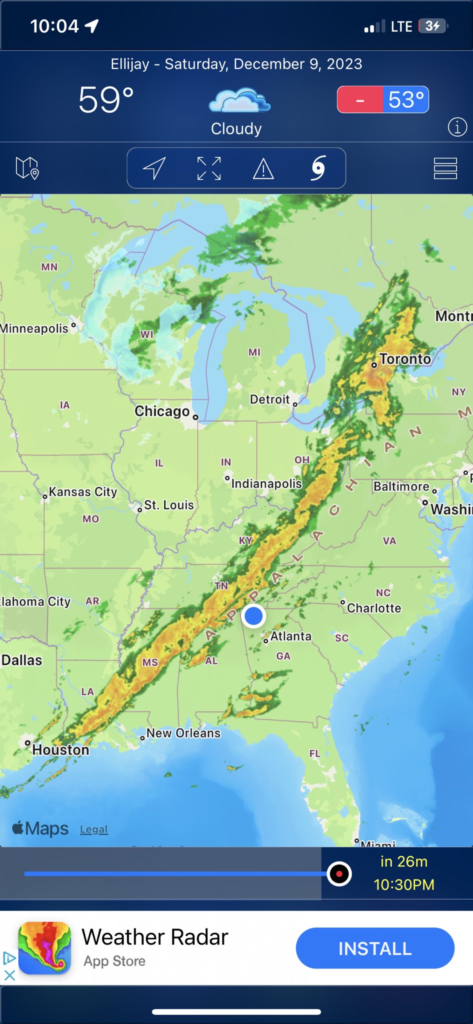
3 AM here in N GA. Awakened by sound of high wind and rain pelting the house. Thunder in area.
This isn’t even the main storm front.
Watching the bowed area of storms east of Gadsden AL. Looks rough. Storms in the Gadsden area often track to this region as they track east.
Staying watchful. I can nap tomorrow afternoon 😉
Update: weakening as it crossed the border into Ga.
Power transformers.
Disclaimer: Opinions posted on Free Republic are those of the individual posters and do not necessarily represent the opinion of Free Republic or its management. All materials posted herein are protected by copyright law and the exemption for fair use of copyrighted works.