Map of the Austro-Hungarian Monarchy: Kingdom of Hungary (green) and the autonomous Kingdom of Croatia-Slavonia (red).These areas comprised the borders of the Kingdom of Hungary within the Habsburg monarchy. 
Nazi Germany's annexation of the Sudetenland, 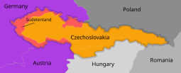
In green the Lands of the Crown of Saint Stephen (Transleithania), the Hungarian territories in the Austro-Hungarian monarchy consisting of the Kingdom of Hungary and the Kingdom of Croatia-Slavonia. Hungary also jointly governed the Condominium of Bosnia and Herzegovina (blue) with Austria (Cisleithania). 
Partition of the Kingdom of Hungary in 1541 
Hungarian irredentism in the 1930s led Hungary to form an alliance with Nazi Germany.
https://upload.wikimedia.org/wikipedia/commons/thumb/3/3e/Territorial_gains_of_Hungary_1938-41_en.svg/180px-Territorial_gains_of_Hungary_1938-41_en.svg.png
Map of Switzerland showing in purple the Italian-speaking areas, where Italian irredentism was strongest 
https://en.wikipedia.org/wiki/Italian_irredentism
A map of the 14th-century Serbian Empire 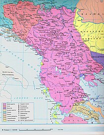
Expansion of the Grand Duchy of Moscow, Tsardom of Russia and Russian Empire between the 14th and 20th centuries. 
Russian expansion in Eurasia between 1533 and 1894 
Map of territorial changes in Europe after World War I (as of 1923) 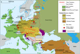
Regions of Ukraine annexed by Russia since 2014 (Crimea) and 2022 (Donetsk, Kherson, Luhansk and Zaporizhzhia), with a red line marking the area of actual control by Russia on 30 September 2022. 
Mexico 1824 (equirectangular projection).png 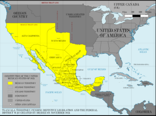
https://en.wikipedia.org/wiki/File:Mexico_1824_(equirectangular_projection).png
Territorial Gains by the U.S. In less than 50 years, the western border of United States grew from the Mississippi River to the Pacific Ocean, starting with the Louisiana Purchase and ending with the territories gained from Mexico in the Mexican-American War. Spain gave up its claim to Florida and the northeastern Gulf Coast, and agreements with Great Britain established the boundary with Canada by 1846. 
https://education.nationalgeographic.org/resource/territorial-gains/
United States land claims and cessions 1782-1802 
https://commons.wikimedia.org/wiki/File:United_States_land_claims_and_cessions_1782-1802.png