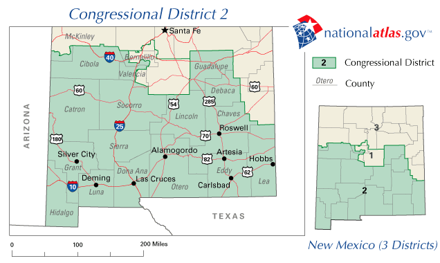
It's been done here in southern New Mexico. I've posted the below on a couple of threads. It will amaze readers who haven't seen it:
In New Mexico, Congressional district 2 occupies the southern half of the state. The boundary is a slightly WNW-ESE line south of the I-40 corridor (south of Gallup, ABQ, Santa Rosa, Clovis). Republican registration is 34%. The area includes lots of Latino voters, the oil and gas fields, Mexican border counties and rural ranchers.
Tea-party conservative Steve Pearce won re-election with 59.2% of the vote not only in the oil patch but in most counties too (The Democratic candidate was Evelyn Madrid Erhard). I'm not sure of his secret (besides hard work) but the GOPe needs to emulate this for future victories.
Democratic counties and percentages:
Republican counties and percentages:
- Bernalillo 45-54
- Cibola 49-50
- Dona Ana 47-52
- Grant 48-51
- Guadalupe 44-55
- Luna 49-50
- McKinley 49-50
One more thing -- Lea, Eddy and Chaves counties make up SE NM Oil Patch - jobs are plentiful, "help wanted" signs everywhere, and skills bring a premium salary and benefits. These folks vote to protect their jobs and are rightfully wary of what Obama will do shut down their livelihood.
- Catron 74-25
- Chaves 68-31
- DeBaca 72-27
- Eddy 67-32
- Hidalgo 60-39
- Lea 79-20
- Lincoln 71-27
- Otero 65-33
- Roosevelt 79-19
- Sierra 64-35
- Socorro 56-42
- Valencia 56-42
