THANK YOU -- for actually reading the report and commenting on a specific section of it! That's a welcome relief from the knee-jerk cynicism and negativism that pollutes FR nowadays...
That section -- and this one, are, IMO, the real "takeaways" from this report:
"USG or Industry Developmental Programs" Some UAP observations could be attributable to developments and classified programs by U.S. entities. We were unable to confirm, however, that these systems accounted for any of the UAP reports we collected.~~~~~~~~~~~~~~~
That sounds like a tacit admission that US advanced systems with some of the observed capabilities do, indeed, exist -- but they were (supposedly) not operating in the documented airspace (on the documented date).
~~~~~~~~~~~~~~~
Some FReepers, I'm sure, are familiar with the "captured UFO" claims associated with the "S-4" area southwest of the Groom Lake ("Area 51") complex in Nevada. Specifically, sections of the mountains adjacent to Papoose Lake purportedly are large hangar doors -- painted to resemble undisturbed terrain. I've examined the entire Papoose Lake area thoroughy with OHI -- and can detect no areas (including approach roads or pads) that fit the "S-4" claims.
However, at 37.15934, -115.927587 -- atop the mountains to the northwest of Papoose Lake -- at the dead end of a long road -- is an area known as "S-4 High Ridge". The road ends in a cul-de-sac, with what could be a guard shack -- and a pair of ~100' square concrete pads.
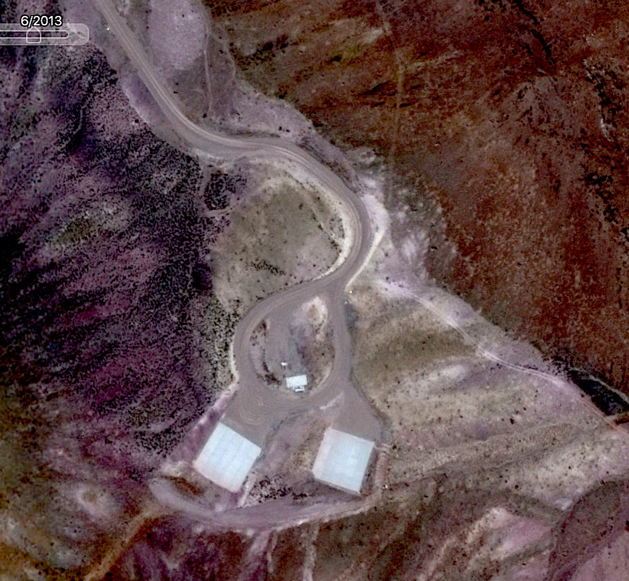
Those pads, in that isolated spot (some 13 miles from the "Janet Airlines" ramp at Area 51) are obviously usable only by craft with full VTOL capabilities. (Helicopters fit that description -- but why put two isolated helipads in near-inaccessible mountains?)
Fortunately, the 11-2015 Google Earth overflight may provide a clue: It was made well after sundown...
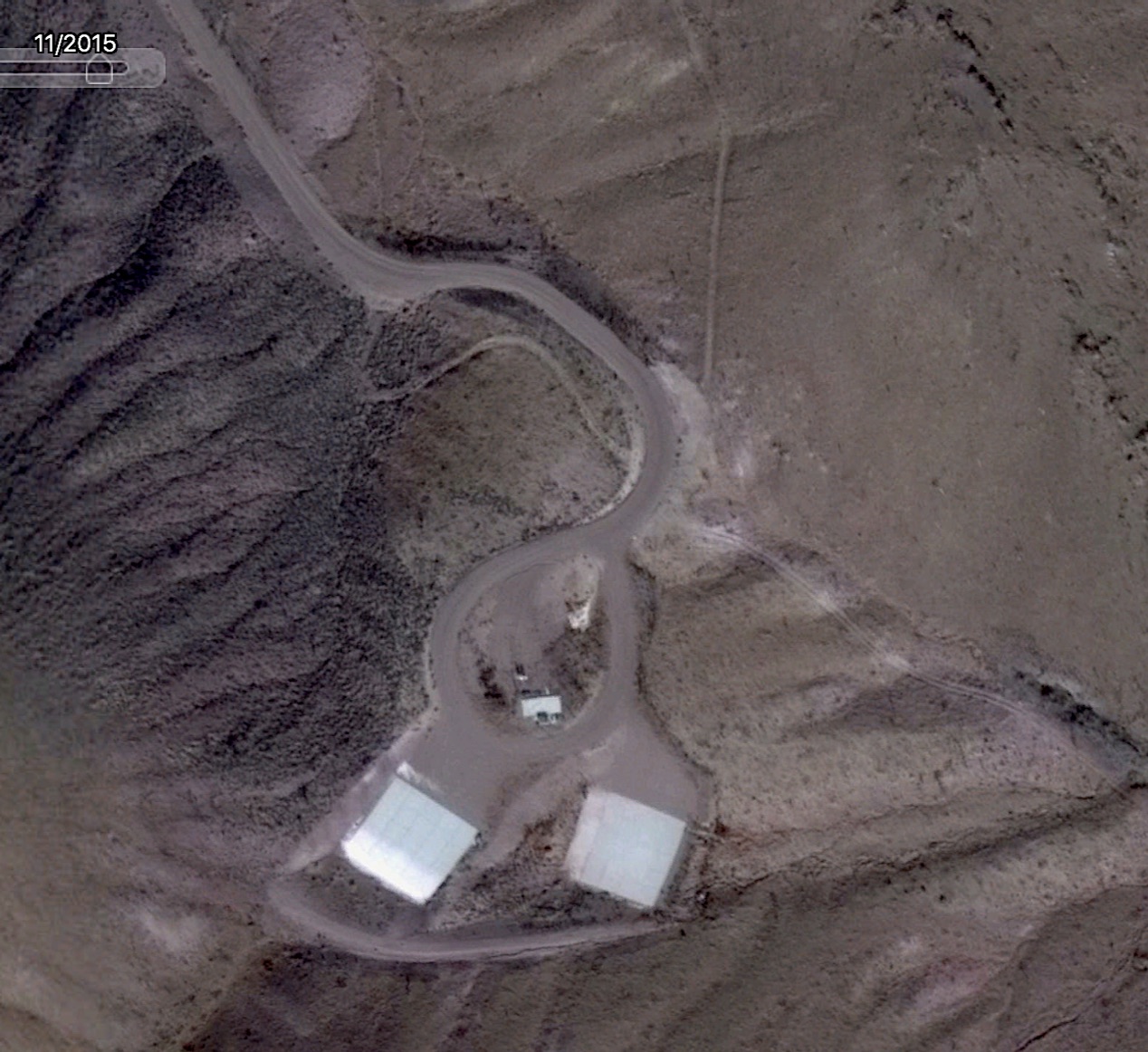
Note the illuminated rectangle on the left pad. That looks very much like "light spillout" from a brightly-lit hangar -- through an open (normally-camouflaged) hangar door.
Helicopters (even Ospreys) are pretty much "old news"... Even stealth heicopter developments could be kept out of sight in Area 51's hangars.
Could whatever's tested at "S-4 High Ridge" be some of the "USG or Industry Developmental Programs" mentioned in the UAP Report?
~~~~~~~~~~~~~~~~~
BTW, anyone who wants to repeat my observations can put the above lat-long coordinates in the Google Earth "search field" -- and (using the "Time Slider Clock") zoom in on the above overflight images -- and "snoop" for yourself...
And, while you're "in the area" you might as well check out all the "slump craters" from nuke testing under Frenchman Flats, just six mies or so to the west...
Enjoy!
TXnMA