Apparently it’s a relatively short haul from the neighboring island. (Tex - is that Greater St James?). Yes, the closest neighboring island is GSJI.
I haven’t seen or heard where the power ultimately comes from though. I imagine a larger power generation plant on a larger island?"
~~~~~~~~~~~~~
On Epstein's "Development Plan" for GSJI, it shows an underwater utilities line (shown in yellow, below) [apparently] running from nearby (large, heavily populated -- with airport) St. Thomas Island. (I guessed at where it may have originated on St. Thomas...)
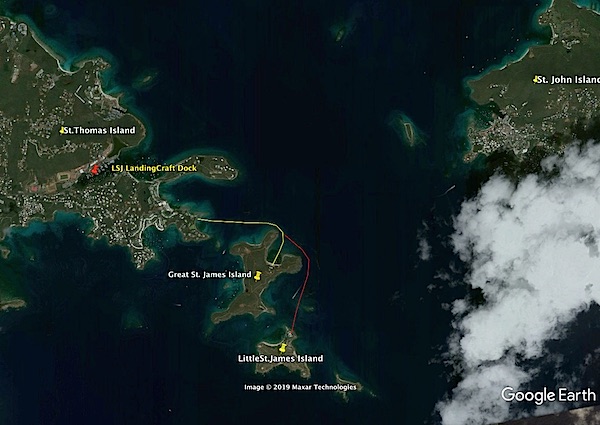
The GSJI line runs into the natural harbor -- at the closest point to the main planned settlement.
I've sketched (in red) a continuation of the GSJI underwater line -- extended to the northern point of LSJI -- where the main (residential) settlement is.
I suppose the LSJI line could run across that narrow isthmus on GSJI -- BUT -- Epstein only acquired GSJI in 2016. (Hence my assumption that the line to LSJI is from St. James -- and, underwater all the way...)
~~~~~~~~~~~~~~
Which raises the questions: "If LSJI had ample electrical power, WTH was going on in that "HVAC" building?
And, why the two vertical ?engine exhaust stacks?
And, the original question: What was/is causing that persistent, localized algae bloom?
TXnMA

P.S. I wasted a slug of time -- trying to find a map that showed both St. James & St. John islands -- with LSJI & GSJI at reasonable scale! Finally went to Google Earth -- but it is a messy combo of lo-res images, mis-matched overflight patches -- and cloud cover. SO -- WYSIWYG!
P.P.S. DOH! Probably could have used Google Maps or Apple Maps... :-{
Anyway, for grins, I "placemarked" the dock where the landing craft, "LSJ" is moored -- when it's not at LSJI or GSJI...