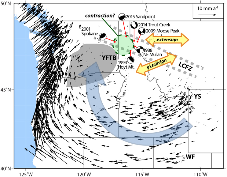
Rotation of the Earth’s crust causes extension along the Lewis and Clark Fault Zone (LCFZ) and contraction in Sandpoint, Idaho, triggering earthquakes. Credit: Daisuke Kobayashi, University of Idaho, Moscow
Rotation of the Earth’s crust causes extension along the Lewis and Clark Fault Zone (LCFZ) and contraction in Sandpoint, Idaho, triggering earthquakes. Credit: Daisuke Kobayashi, University of Idaho, Moscow
Obviously global warming.
Or fracking.
Basin and range geology of the northern part.
Bush’s fault
Seems to me like a bunch of expansion can cause contraction in the areas between the expansions.
Outward pressure from the growing supervolcano in Yellowstone, perhaps?
A lot of earthquakes are plates slipping past each other and also one under another.
Dr. Peter Venkman: This city is headed for a disaster of biblical proportions.
Mayor: What do you mean, “biblical”?
Dr Ray Stantz: What he means is Old Testament, Mr. Mayor, real wrath of God type stuff.
Dr. Peter Venkman: Exactly.
Dr Ray Stantz: Fire and brimstone coming down from the skies! Rivers and seas boiling!
Dr. Egon Spengler: Forty years of darkness! Earthquakes, volcanoes...
Winston Zeddemore: The dead rising from the grave!
Dr. Peter Venkman: Human sacrifice, dogs and cats living together... mass hysteria!
Hope it’s not that lava dome under Yellowstone....
“Rotation of the Earth’s crust “
How does the surface of a sphere rotate? Should this say “rotation of the [whatever] plate?”
Daisuke Kobayashi, University of Idaho, Moscow
Wow, talk about geographic confusion!
Magma rising.
It's Global Warming!
Any info on depths? Thanks.
0.2 to 18km for San Point over the past 3 months, trending NNW/ESE.
Four to seven months ago, a series trending N/S with a 2.7 at 20km.
These have been pretty mild with the greatest at 4.3, 9km. Though they seem to indicate a fairly complex variety.
Some very shallow, some quite deep for a significant distance from west coast subduction.
Your map indicates a rotational setting semi-surrounding this array from E to NNE.
Seems an interesting paper could come out of it.