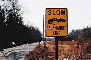
Let them use bridges.


Posted on 01/22/2012 6:08:48 AM PST by SJackson
Development is squeezing animals into smaller pockets of land, and without sufficient planning and protection, individual animal populations could find themselves increasingly isolated.
To address this issue, researchers have been reestablishing and protecting connections on the landscape for many years, from building highway crossings to maintaining swaths of forest. These wildlife corridors are designed to enable the meanderings and migrations of animals. As scientists' efforts to improve the quality of these connections become increasingly sophisticated and more mathematical, they are finding that solving the problem has much in common with what happens when someone asks an online service to provide driving directions between two points on a map.
For planners, the goal is to preserve or create effective connections for wildlife at low cost, just as online map services aim to route travelers in the most efficient way possible. Designing a landscape to simultaneously serve the needs of multiple animal species is much more difficult because each may prefer a different type of environment. It's similar to trying to find the single best set of directions between two points for multiple modes of transportation, such as driving, walking, and mountain biking.
"Because they bring several dimensions, these problems are computationally much harder," said Carla Gomes, a computer scientist from Cornell University in Ithaca, N.Y. "If the problem is to connect just two terminals, for one species, then that problem is exactly the same computationally speaking as the problem that Google solves when I ask for the shortest path, for the fastest way to go from Boston to Ithaca, N.Y."
Michael Schwartz, a research ecologist with the U.S. Forest Service's Rocky Mountain Research Station in Missoula, Mont. had been gathering genetic data for more than 10 years and began to find that the methods they were using to analyze certain wildlife management topics were insufficient.
"We got to the point where the math became intractable to us," said Schwartz.
Ads by Google
Wildlife Management - Environmental Science - Fish and Wildlife Mgt. Degree. Accredited. - www.APUS.edu
Schwartz started working with Claire Montgomery, a forest economist at Oregon State University in Corvallis, who had been developing methods to address both animal populations and timber management strategies.
"I was beginning to look at problems where uncertainty played a much bigger role than it had in the past in my research," said Montgomery. "And that kind of created a whole new dimension to the problem that I didn't even have a clue how to address computationally."
Multi-Purpose Land Use
Land can be managed with many different outcomes in mind. The land might be used to provide timber or to preserve native species while simultaneously being used for public recreation. Finding the best outcome for many competing interests can be complicated.
One option is providing stable habitat areas for wildlife and connecting them with corridors that enable animals to roam or migrate safely.
These competing interests make compromises inevitable. Analyzing the potential outcomes of different strategies on the inhabitants and resources that rely on a piece of land is complicated, and when the equation also includes the cost of purchasing additional land to provide those wildlife corridor areas, tradeoffs are unavoidable. Setting up a decision-making process with easily understood priorities is also important. Finding the best solution requires computational power and advanced algorithms.
"We felt pretty good about that approach for a single species," said Schwartz. "The question became, 'What happens when you look at multiple species?'"
About two years ago, Schwartz and Montgomery started working with Gomes, who is developing a new field she calls "computational sustainability." It combines aspects of ecology, economics and operations research to intensely analyze data to reveal more comprehensive solutions to difficult problems.
"You want to optimize the quality of the corridors you get for a given budget you have," said Gomes. "A lot of these problems are really highly computational."
Identifying the crucial pieces of land that offer the greatest preservation potential for many animal species and not just one is a multi-layered problem that requires intensive analysis. Consider that the best corridor for grizzly bears may not be ideal habitat for wolverines, and the best compromise for those two may not assist birds.
Factoring in the impacts of those corridors on how humans use the land in question makes the problem more complex.
Useful Data
Ecologists can collect massive amounts of data about animal habits, movement patterns and more. But, even while many of them have expertise in some of the issues at hand, bringing together a multidisciplinary team may be required to identify the most important pieces of land to protect.
The data revolution of recent decades has resulted in increased computational power that has appealed to others researching related topics as well.
"We've obviously benefited tremendously from the ability to do some of these more complex modeling and mathematical computations that weren't available to us when it was done by paper and pen," said Jon Beckmann, a conservation scientist for the Wildlife Conservation Society's North American program who doesn't work with the team. "We've gone from expert-based opinion modeling to models that are based on actual field data."
Beckmann trained as a field ecologist and has had training in computational techniques, but feels that the power of analysis is only as powerful as the data used to underlie the models.
"What you do is build teams with biologists or ecologists that have these strengths because you need both components," said Beckmann. "As we develop these new mathematical capabilities and theories, then it's a continual process that's always changing."
Corridors are complicated and they must be crafted to appeal to animals and in a way that maintains animals' safe passage. If a corridor is designed in a way different from how animals travel the landscape, then it might not work as intended.
"Animals don't read signs," said Cheryl Chetkiewicz, a conservation biologist with Wildlife Conservation Society Canada, who also doesn't work with the team. "It's about maintaining flow. Flows of animals, flows of energy, flows of plants…Corridors are one conservation tool to maintain these flows and avoid barriers in some areas."
Researchers can attempt to translate these factors into models and equations for computer analysis. But Chetkiewicz, who has also studied intact landscapes, isn't convinced that corridors are the best or only solution to the problems faced by animals while they travel. Corridors are a popular management tool, but they don't necessarily represent the ideal situation from an animal's point of view.
"Corridors to me are a last ditch effort to reconnect patches that used to be connected," said Chetkiewicz.
Applying Models to Real Problems
Schwartz said that the models he developed with Montgomery and Gomes are complex and layered, so translating them into a form that land managers can understand and use is critical to protecting contemporary and future landscapes. Schwartz said that without that next step of translating computer model results into the protection of land, animal habitats may collapse to form what he said a colleague calls "a bunch of isolated zoos."
This makes it important to be able to effectively communicate the science to land managers, who report to the public and must be able to make effective and transparent decisions.
The problem can be simply stated, but the solution may not be obvious. Tracking the effects of choices on numerous variables and finding the best overall outcome really is difficult.
"In the past in most forestry applications we look at a particular landscape and we find a management strategy for that landscape, but it's specific to that landscape and to the spatial configuration of vegetation and roads and so on and you can't take it anywhere else," said Montgomery.
"What we are trying to do is combine what the animals like with the reality of economic constraints and budget constraints," said Gomes.
Let them use bridges.
Or under the roads in culverts.
http://au.news.yahoo.com/world/a/-/world/12480407/wildlife-find-path-to-safety-under-us-roads/
Very cool.
Let George Soros build them with his money.
In SW Montana I believe they are working on fence designs that allow antelope to squeeze under, but keep the cattle in bounds.
I’m OK with common sense things that don’t cost me any money.
Soros can pay for the maintenance, too. Something with that kind of design will need a deep base for trees to establish on. But then comes winter with its deep freezes. How fast will that break up the structure with the moisture in there?

Corridors - a watchword - In the slaughterhouse they funnel the livestock in ever narrowing corridors and at the end they become dead meat walking.
Agenda 21 is big on corridors and isolated pockets.
Soros is probably a big Agenda 21 proponent.
Be alert or be a dead slave walking.


“Corridors - a watchword - In the slaughterhouse they funnel the livestock in ever narrowing corridors and at the end they become dead meat walking. Agenda 21 is big on corridors and isolated pockets.Soros is probably a big Agenda 21 proponent. Be alert or be a dead slave walking.”
Bingo.
BWAHAHAHAHA!
Give me a break, Chris. It's more like...
Designating human corridors in the digital age
The valuation of animals over humans is rather morbid, IMO.
Serfs are made in such ways!
Looks like a good job to use the National Guard. Keep the animals safe and all.
If you want to be on or off the Agenda 21 ping list, please notify me by Freepmail. It is a relatively low volume list in which we have been exploring the UN Agenda21 and related topics. We have collected our studies with threads, links, and discussions on the Agenda 21 thread which can be found here:
http://www.freerepublic.com/focus/f-news/2738418/posts
One of our participants, Whenifhow, has recently been doing some research on some things which have come to his/her attention and wanted to share what he/she found. (I will use the masculine pronoun for ease of written English...Whenifhow, if you are female, please excuse me!) He started looking into information on the Hewlett Foundations and ran into some interesting links, which follow. As of a couple days ago, the links were working.
Neither of us are seeking to do any fill-in-the-dots connections, but are offering these pages as being of interest in and of themselves, but also perhaps helpful for those who ARE seeking to make those connections, or would find the pages helpful for providing links for other researches in related topics.
This is a document entitled “Spectacular Migrations in the Western US, by Keith Aune and Elizabeth Williams. It relates directly with the topic of this thread. Whenifhow directs us to page 5 of the document. There is quite an interesting chart that some may find instructive on the “Quadrant Approach.”
http://www.wcs.org/files/pdfs/Spectacular-Migrations-in-the-Western-US-Version-3.pdf
Strategy Planning tool for Western Conservation
http://www.hewlett.org/uploads/files/Hewlett_Found_Western_Conservation_Strategy_Planning_Tool.pdf
Whenifhow comments that the FOUNDATION’S GOAL IS TO ENSURE THE ECOLOGICAL INTEGRITY of the West to benefit wildlife and people. The strategy planning tool includes targets for ecosystems, species, core areas, connectivity corridors, greenhouse gas emissions, and sustainable human uses. The specific targets are guided by scientific and other expert input and are updated as information improves.
He indicates that: page 2 of the following 3 page document lists various foundations which would be of interest to research who the writers of the document are hoping will come on board with money to support their efforts. Listings of the Foundations include commentary of their role in “food security” and “sustainable agriculture.”:
http://www.whitehouse.gov/files/documents/g20/Pittsburgh_Fact_Sheet_Food_Security.pdf
Gates Foundation, Rockefeller Foundation, Hewlett Foundation, Rabobank Foundation, World Economic Forum, Initiative for Global Development
PLEASE NOTE THAT THE WORLD ECONOMIC FORUM STARTED ITS MEETING TODAY, 1/25/12 IN DAVOS, SWITZERLAND. If you are inclined to pray about such things, please ask the Lord to take command of that meeting and let only His Will be done!
This is the United States Mission to the European Union page. It has quite a number of relevant articles and links that are of interest to our studies:
http://www.useu.be/
Obama Administration Details the US Agenda for UN Reforms page. It sounds good, but fear there is a twist or layer that may not be addressed in this public policy statement. Supposedly Obama is wanting for the UN to do more with less of the US taxpayer money.
http://iipdigital.usembassy.gov/st/english/article/2012/01/20120120155253eiznekcam0.1052667.html?CP.rss=true#axzz1kWFRFjF6
Here is a page of Ambassador Rice on Obama's Agenda for UN Reform.
http://iipdigital.usembassy.gov/st/english/texttrans/2012/01/20120120090243su0.5017293.html?CP.rss=true#axzz1kWFRFjF6
Here is a link to a UN website document entitled “Sustainable Production and Consumption.” It deals with two areas of concern, “1.Domestically-focused Agencies and Programs” and “2.Internationally-Focused Agencies and Programs.” That takes in a lot of territory and is quite a long document, but worth looking at.
http://www.un.org/esa/dsd/dsd_aofw_ni/ni_pdfs/NationalReports/usa/scp.pdf
Non-Federal agricultural and forest lands occupy 1.4 billion acres or nearly 70 percent of the contiguous United States. U.S. land types include forests (28 percent), croplands (20 percent), urban, suburban and rural residential areas, (6 percent), miscellaneous other uses (7 percent); and special uses—primarily parks and wildlife areas (13 percent)—
(http://www.ers.usda.gov/publications/sb973.pdf.). In addition to supporting the agriculture and forest sectors, farms and forests also provide a range of ecosystem services including wildlife habitat and corridors that support healthy wildlife populations, filter groundwater supplies, regulate surface water flows, sequester carbon, and provide open space and scenic vistas that improve quality of life for people. Increasingly, methods of valuing and accounting for ecosystem services associated with landscapes and their management are being developed and implemented. (See USDA Office of Ecosystem Services). ESRI Conservation Program Resources: General Conservation
www.conservationgis.org/links/conserve.html
Some of the largest funding agencies are listed on this page. The excerpt below is just one of them.
American Association for the Advancement of Science, Population and Sustainable Development Program Dc e98 . (200 New York Avenue NW, Washington DC 20005 Tel: (202) 326-6658 * Fax: (202) 289-4958 Email: vdompka@aaas.org GIS Contact: Lars Bromley )
“Funded by a grant from the Summit Foundation, PSD is currently collaborating with the World Wildlife Fund (WWF) and The Nature Conservancy (TNC) to use ArcInfo and ArcView to manage and display the datasets which best depict population-environment interactions. PSD is drawing on the AAAS membership—the worlds largest federation of scientific and engineering societies—and our international contacts for expertise in choosing, analyzing, and commenting on the data gathered to ensure the greatest accuracy....Our outputs from this project will be extensive.
First, a publication entitled “A World Atlas of Populations and the Environment,” will be released in late 1999 to coincide with the anticipated Cairo +5 international population conferences. This Atlas, which Bansen Publishing has expressed interest in, will be distributed among institutions, academia, business, and individuals worldwide. Themes such as ‘Human Populations and Coastal Areas,’ or ‘Human Consumption and CO2 Emissions,’ will be chosen, data gathered from public and institutional sources, and GIS-generated maps created for review.
The most effective of these maps will then be rendered for publishing in the Atlas together with commentary supplied by leading experts in their respective fields.
Smart Growth Funding Resource Guide
www.smartgrowth.org/pdf/funding_resources.pdf
United Nations Owns Most USA National Parks and Park Lands: Did You Know?
http://alternativenewsreport.net/2011/11/22/united-nations-agenda21/
UNESCO established the World Commission on Culture and Development (WCCD) (I could not get this website to open today)
http://www.unesco.org/new/en/social-and-human-sciences/ Statement of the Global Migration Group on the Impact of Climate Change on Migration
http://www.unesco.org/new/fileadmin/MULTIMEDIA/HQ/SHS/pdf/GMG_statement.pdf
From page 2 In view of these challenges, the GMG calls on the international community to recognize that migration and displacement induced by environmental degradation and climate change require urgent action. Specifically, the GMG recommends:
- To adopt gender-sensitive, human rights- and human development-oriented measures to improve the livelihoods of those exposed to the effects of climate change and increase their resilience, in order to counter the need for involuntary movements.
- To pay particular attention to the human rights situation of all people affected by the consequences of climate change, regardless of their legal status: international human rights law, including the fundamental principle of non-discrimination, as well as specific instruments such as the Guiding Principles on Internal Displacement, should guide States’ action towards people who are displaced as a result of environmental factors.
- To explore the complex interrelations between climate change and human mobility in order to collect data, develop expertise and build capacity to address this challenge, and to achieve close cooperation between the climate and social sciences communities to this end.
- To address the migration impacts of both sudden and slow-onset effects of climate change.
- To recognize migration as an adaptation strategy to environmental risks and to make migration an option available to the most vulnerable. Immigration policies could take into account environmental factors in the likelihood of cross-border movement and consider opening new opportunities for legal migration.
- To assist the least-developed countries in responding to climate change by mainstreaming migration and mobility in national adaptation plans.
- To incorporate the relationship between climate change and migration in Poverty Reduction Strategies and national development strategies.
Here’s a listing of the World Heritage sites for the USA, Gettysburg is not included so I do wonder what that AC meant but either way...this is unbelievable.
United States of America
* Mesa Verde National Park
* Yellowstone National Park
* Everglades National Park
* Grand Canyon National Park
* Independence Hall
* Kluane / Wrangell-St Elias / Glacier Bay / Tatshenshini-Alsek # * 33
* Redwood National and State Parks
* Mammoth Cave National Park
* Olympic National Park
* Cahokia Mounds State Historic Site
* Great Smoky Mountains National Park
* La Fortaleza and San Juan National Historic Site in Puerto Rico
* Statue of Liberty
* Yosemite National Park #
* Chaco Culture
* Hawaii Volcanoes National Park #
* Monticello and the University of Virginia in Charlottesville
* Pueblo de Taos
* Carlsbad Caverns National Park
* Waterton Glacier International Peace Park *
* Papahānaumokuākea
http://whc.unesco.org/en/list
From their site:
What makes the concept of World Heritage exceptional is its universal application. World Heritage sites belong to all the peoples of the world, irrespective of the territory on which they are located.
High Seas Recognized as Critical for Sustainable Development in UN Process
http://www.pewenvironment.org/news-room/press-releases/pew-encouraged-that-ocean-protection-is-on-rio20-agenda-85899368825
I (texokie) have just realized as I have previewed this post of the above list, that my html skills are not up to snuff. I did manage to make breaks and paragraphs, but have always had trouble with links. I can do them but it takes me a LONG time.
As I have mentioned in previous posts, my FReep time is quite limited of late. I find I am wanting to get this posted, but have run out of time. PLEASE forgive me the formatting inadequacies and press of time. My apologies especially to Whenifhow, whose research this is.
Thanks for the ping!
Don’t count on Soros or anyone else paying these rural projects. This is all a part of the Agenda 21 Wildlands project, designed to get people off the land and Obama and his friends are way ahead of us on their scheming.
I have recently been made aware of the Delta Technique and have come to the realization that this technique is in heavy use in WA state and probably around the country. It is being used to empower (and fund) NGOs to take over the management of counties and states through what they call, Ad Hoc Stakeholder boards or commissions, that are appointed (in my county, they were appointed by another appointed commission), that insulate the elected politicians from the wrath of the voters.
Obama’s Rural Council is part of this plan because it is designed to expedite the approval of the Gateway projects (part of the Wildlands plan) around the country. The other part is the use of these appointed stakeholder boards that take over the approval process as well as the mitigation funds from the projects, so that the rural areas that bear the burden of the negative impacts of the projects, reap no benefits.
Oh, and it gets better, we, the tax payers get to pay for the mitigation, through Patty Murray’s bill, S. 942.
Disclaimer: Opinions posted on Free Republic are those of the individual posters and do not necessarily represent the opinion of Free Republic or its management. All materials posted herein are protected by copyright law and the exemption for fair use of copyrighted works.