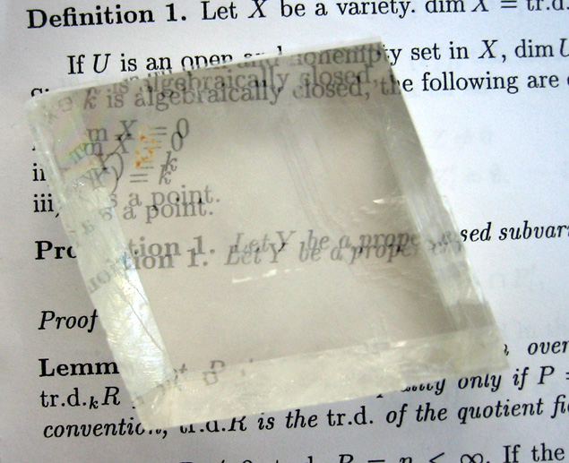
Sunstones are found in Norway, Canada and Russia; once polished they are used in jewellery
Posted on 11/01/2011 8:00:07 PM PDT by decimon
Vikings used rocks from Iceland to navigate the high seas, suggests a new study.
In Norse legends, sunstones are said to have guided seafarers to North America.
Now an international team of scientists report in the journal the Proceedings of the Royal Society A that the Icelandic spars behave like mythical sunstones and polarise light.
By holding the stones aloft, voyaging Vikings could have used them to find the sun in the sky.
The Vikings were skilled navigators and travelled thousand of kilometres between Northern Europe and North America.
But without a magnetic compass, which was not invented until the 13th Century, they must have relied on other navigational aids.
(Excerpt) Read more at bbc.co.uk ...

Ping
Not new but maybe confirming.
At the same time SOME PEOPLE can detect polarized light without the assistance of lenses or sunstones (as they are called). Try: http://www.polarization.com/haidinger/haidinger.html
I read the article, but did not find what an” Icelandic Spar” was. Do you know?
When I was in 6th grade (early 60s) I did a report on the Vikings. It included a bit about how they navigated with sun stones.

It is fascinating, especially since they first had to find Iceland; then find the crystals; then.... *<];-’)
Thanks! Another great, and useful compound filled to the brim with CO2! (CaO+CO2).
|
|
|
| GGG managers are SunkenCiv, StayAt HomeMother & Ernest_at_the_Beach | |

|
|
Thanks decimon. By the same token, fieldstones help navigate fields. |
|
|
|
|
It's long been believed that the mineral iolite (cordierite) was used for Viking navigation. A friend who comes from strong Nordic roots and is an accomplished gemologist/mineralogist put together this nice explanation on her website: Viking Sunstone
Thanks.
Thanks. It’s been over 40 years since I took my introductory mineralogy classes; and never kept it up.
I always think of “sunstones” as those artificial glass teardrop things filled with bronze or copper fillings.
Go here for images of various sunstones: Sunstone Images
Thanks for the link!
My pleasure!
Lakeview, Oregon: Sunstone (Feldspar) Gem Mines
The arid south-central portion of Oregon is a classic volcanic region. There the relatively young rock consists of dark basalts, andesites, rhyolites, ash and cinders. Millions of years ago a magma chamber several miles below the surface supported the correct geochemical conditions for the growth of labradorite, a calcium-rich plagioclase feldspar. ... http://www.mtlilygems.com/mineinfo/plshinfo.html
The Yellowstone hot pocket?
I'm not sure. If you look at a map of Idaho you an see a long volcanic scar across the southern part of the state called the Snake River Plain. It's a huge jumble of basaltic lava flows and the location of the other-worldly Craters of the Moon National Monument. Current theory suggests it's the result of the American plate moving westward over the Yellowstone Hot Spot (which remains stationary.) It's a process that seems to be continuing.
Oregon and the West Coast in general have seen plenty of volcanic action and it's going to continue. I have a hunch the sunstone region is more likely the result of volcanism related to subduction of the Pacific Plate under the American plate. Subducted rock forms magma chambers resulting in active volcanoes like the Three Sisters at Bend, Mt. St. Helen's, etc., extending south to Lassen and Shasta in California and all the way to the tip of Chile.
We're lucky to live in a time when those Ring of Fire volcanoes are relatively inactive. Think of what it would have been like if we'd been around when the Columbia Plateau Flood Basalts were forming! Columbia Plateau
Nope; wouldn’t be the Hot Spot. McDermitt Caldera is the one I was thinking of, but that is over 100 miles east of Lakeview; about 175 miles ESE of the sunstone fields in that link. That entire region is volcanic, one way or another.
And, no; I would not have wanted to be anywhere even half way near any flood flows. We had andesite flows in the Medford area, most notably visible as Upper & Lower Table Rock.
We used to drive across central & south eastern Oregon a lot. The state/counties have pits where they dig, screen, & stockpile red lava gravel, mainly for ‘sanding’ the roads in winter. Those deserted pits also make decent ‘pit stops’, during some of which we picked up a life time supply of bath-grade grey pumice stones.
Loved our visit to Craters of the Moon.
Disclaimer: Opinions posted on Free Republic are those of the individual posters and do not necessarily represent the opinion of Free Republic or its management. All materials posted herein are protected by copyright law and the exemption for fair use of copyrighted works.