Skip to comments.
It’s the blob (anomaly)! ( A giant temperature anomaly is attacking Canada and Greenland.)
Wattsupwiththat.com ^
| March 19, 2010
| Anthony Watts
Posted on 03/19/2010 11:46:20 AM PDT by Ernest_at_the_Beach
click here to read article
Navigation: use the links below to view more comments.
first 1-20, 21 next last
To: All
From the comments:
****************************************
Veronica
As Pearland Aggie says, a lot of this effect is due to the map projection used.
It’s probably a small campfire from somebody’s polar bear hunting expedition.
To: SunkenCiv; Marine_Uncle; Fred Nerks; steelyourfaith; NormsRevenge; onyx; BOBTHENAILER; ...
Not sure what this means....but WUWT thought enough of it to post it!
To: Ernest_at_the_Beach
Yep. Map projection + its a % deviation from norm, not an actual temperature.
To: agere_contra
My bad, its a temperature contour.
So, lousy use of map projection tracking a single campfire and conflating it to the size of Britain.
To: Ernest_at_the_Beach
I think that *pink* area was over Texas last summer. (now it’s cooler than average)
6
posted on
03/19/2010 11:55:53 AM PDT
by
wolfcreek
(http://www.youtube.com/watch?v=Lsd7DGqVSIc)
To: All
From:
Latest Global Temps
****************************EXCERPT**********************************
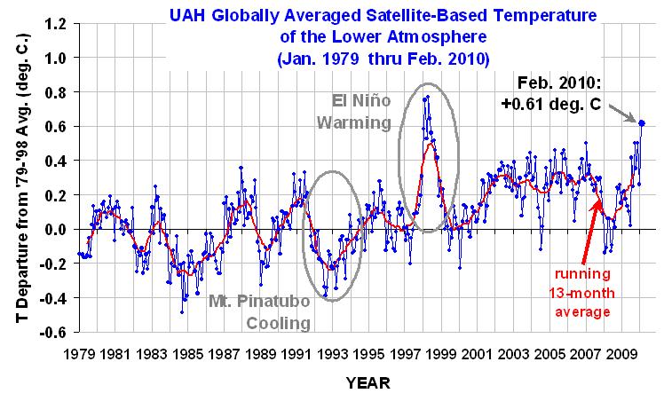
Latest Global Average Tropospheric Temperatures
(Want to see how the current month’s temperatures are shaping up? Check this out.)
Since 1979, NOAA satellites have been carrying instruments which measure the natural microwave thermal emissions from oxygen in the atmosphere. The signals that these microwave radiometers measure at different microwave frequencies are directly proportional to the temperature of different, deep layers of the atmosphere. Every month, John Christy and I update global temperature datasets that represent the piecing together of the temperature data from a total of eleven instruments flying on eleven different satellites over the years. As of early 2010, our most stable instrument for this monitoring is the Advanced Microwave Sounding Unit (AMSU-A) flying on NASA’s Aqua satellite.
The graph above represents the latest update; updates are usually made within the first week of every month. Contrary to some reports, the satellite measurements are not calibrated in any way with the global surface-based thermometer record of temperature. They instead use their own on-board precision redundant platinum resistance thermometers calibrated to a laboratory reference standard before launch.
To: Ernest_at_the_Beach
I’ve had a window open on that for an hour! Just haven’t broken loose to read it. Lots of action of all sorts today.
To: agere_contra; wolfcreek
To: Ernest_at_the_Beach
10
posted on
03/19/2010 12:13:38 PM PDT
by
wolfcreek
(http://www.youtube.com/watch?v=Lsd7DGqVSIc)
To: Ernest_at_the_Beach
Maybe this is where our earthquake machine is at the moment.
To: Ernest_at_the_Beach
I always wondered what kind of phenomena may occur when the Earth’s magnetic poles are getting ready to flip .. space weather in action.
12
posted on
03/19/2010 12:46:11 PM PDT
by
NormsRevenge
(Semper Fi ... Godspeed .. Monthly Donor Onboard .. Chuck DeVore - CA Senator. Believe.)
To: NormsRevenge
when the Earth’s magnetic poles are getting ready to flip .. space weather in action.Ok....I have been focused in on this Global '"Warming Hoax'"...
So what is this about the magnetic poles flipping?
To: Ernest_at_the_Beach; 11B40; A Balrog of Morgoth; A message; ACelt; Aeronaut; AFPhys; AlexW; ...
To: Ernest_at_the_Beach; Tunehead54; Clive; Fractal Trader; tubebender; marvlus; Genesis defender; ...
15
posted on
03/19/2010 2:02:27 PM PDT
by
steelyourfaith
(Warmists as "traffic light" apocalyptics: "Greens too yellow to admit they're really Reds."-Monckton)
To: Dr. Bogus Pachysandra
I’ve had a window open on that for an hour! Aha! The source of the temperature "anomaly"!
:-)
16
posted on
03/19/2010 2:06:19 PM PDT
by
EternalVigilance
(TATBO - "Throw All The Bums Out")
To: EternalVigilance
To: Ernest_at_the_Beach
18
posted on
03/19/2010 3:03:45 PM PDT
by
SunkenCiv
(http://themagicnegro.com/)
To: Ernest_at_the_Beach
You mean Mister Mercator’s projection distorts everything except the equitorial regions; progressively magnifying and distorting areas, the closer to the poles one gets?
Golly, wonder why they don’t teach this in schools....
I would love to see the same data plotted on an equiareal projection.
19
posted on
03/19/2010 6:11:27 PM PDT
by
ApplegateRanch
(Islam: a Satanically Transmitted Disease, spread by unprotected intimate contact with the Koranus.)
To: Ernest_at_the_Beach
Got to hit the rack. But I cannot help notice if we looked back the last few months of 2009 through January of this year upper Canada had very low extended temperatures. Guess we shall soon see if it is trending to the warm side in this red area or not.
20
posted on
03/19/2010 7:04:24 PM PDT
by
Marine_Uncle
(Honor must be earned....)
Navigation: use the links below to view more comments.
first 1-20, 21 next last
Disclaimer:
Opinions posted on Free Republic are those of the individual
posters and do not necessarily represent the opinion of Free Republic or its
management. All materials posted herein are protected by copyright law and the
exemption for fair use of copyrighted works.
FreeRepublic.com is powered by software copyright 2000-2008 John Robinson

