To: freepersup; XBob; wirestripper; Budge
Budge,
Can you jpg the graphic labelled "Crossing California"?
Let's see if we can predict the location of the object that separated from the orbiter and observed by the astronomers in Owens Valley.
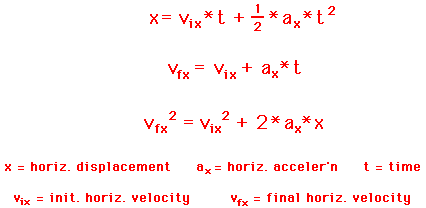
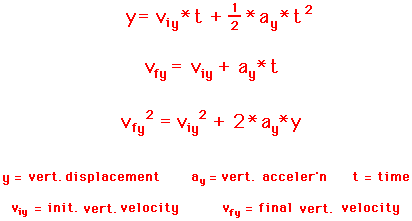
Let's do an elementary physics problem. An object has a particular height and velocity. Calculate the distance that the object travels prior to impact.
Y = height
v = velocity
On the slide labelled "Crossing California" a blue dot over Yosemite National Park is labelled with the following data:
13:54:20 GMT +/- 60 sec (34)
(13:53:20/55:20)
Start of slow aileron trim change. GMT is approximate
Let us assume that the vehicle had increased drag just prior to this point due to a component that is creating drag.
Let is attempt to estimate the point at which the object creating the drag separated from the vehicle by comparing the astronomical observations with the inflight data acquired by Mission Control and then released by NASA.
The prior data point which NASA labelled is at:
13:54:10 GMT (33)
38.4162, -120.1739
LMG Brake Line Temp B - Start of Off-Nominal Trend - Temp Increase. H = 228460 ft. Mach 22.64
I will define this data point as CA-1
A second datapoint is labelled at:
13:54:24 GMT (35.5)
38.27043, -119.0681
Sys 3 LMG strut Actuator Temp - start of off-nominal trend - unusual temp rise
H=227437 ft
V=Mach 22.51
Using the two datapoints, I have created a line on my Microsoft MapPoint program (which appears to be the same program NASA is using).
I'm going to attempt to find the discussion written by the Cal Tech astronomers.
1,674 posted on
02/13/2003 10:43:42 PM PST by
bonesmccoy
(Defeat the terrorists... Vaccinate!)
To: bonesmccoy
Interesting idea, estimating the location.
At this point, I would estimate that the molecules are floating somewhere over the mid-atlantic.
I don't think any of the western 'flares' reached the ground. However, I may be wrong. That big one may be out there somewhere, but it seems to me that the flares over Owens Valley were only small ones.
1,678 posted on
02/13/2003 10:54:50 PM PST by
XBob
To: bonesmccoy
northwest of Kanab, Utah
13:55:49 GMT
"Orbital Sunrise" (Vehicle Moves From Earth's Shadow to Sunlight)
northwest of Marble Canyon, Arizona
13:56:02
QBAR = 40psf
Aft RCS Pitch Jets Deactivated
H 221,670'
mach 21.45
northwest of Marble Canyon
13:56:03
Left Lower Wing Skin Temp- Start of Off- Nominal Trend- Temp Reading Trending Down potential sensor/wire damage
H 221,612'
mach 21.44
This is the time line of the shuttle coming out of the southwest corner of Utah and into the northwest corner of Arizona. The kids filming at Waputki National Monument, northeast of Flagstaff will be picking the shuttle up at any moment on film, if they haven't already.
1,679 posted on
02/13/2003 10:58:28 PM PST by
freepersup
(And this expectation will not disappoint us.)
To: bonesmccoy
Formula for parabolic trajectory of a ballistic object:
1,680 posted on
02/13/2003 11:00:19 PM PST by
bonesmccoy
(Defeat the terrorists... Vaccinate!)
To: bonesmccoy
The shuttle is crossing northern Arizona according to this time line and is under observation by the kids filming at Waputki NationalMonument.
east of Kaibito, Arizona
13:56:16 GMT
Hyd Sys 1 LMG
Uplk Actr Unlk Ln
Temp- Temp rise Rate Change from 0.7 F/min (nominal) to 3.9 F/min and increasing to LOS
H 220,778'
mach 21.28
east of Kaibito, Arizona
13:56:17
Sys 3 LMG Brake SW Vlv Ret
Line Temp (FWD)- Temp Rise Rate Change from 1.5 F/min to 8.8 F/min (not increasing) to LOS
H 220,711
mach 21.27
east of Kaibito, Arizona
13:56:22
LMG Brake Line Temp B Temp rise Rate Change from 2.1 F/min to 9.1 F/min increasing to LOS
H 220,374
mach 21.21
The above events are unfolding overhead as the kids continue filming from Waputki National Monument.
1,690 posted on
02/13/2003 11:19:24 PM PST by
freepersup
(And this expectation will not disappoint us.)
To: bonesmccoy
Below are the two final sensor readings from NASA, as the shuttle crosses northern Arizona and into New Mexico air space.
south of Shonto, Arizona
13:56:24 GMT
Left Upper Wing Skin Temp- Start of Off- Nominal Trend Temp Reading Trending Down potential sensor/wire damage
H 220,235
mach 21.17
southeast of Shonto, Arizona
13:56:30
1st Roll Reversal Initiation
H 219,820
mach 21.13
The shuttle passes out of range of the kids video camera and crosses into New Mexico. 23 seconds elapse before the next sensor reading provides NASA any kind of useful data.
east of Tohatchi, New Mexico
13:56:53 GMT
SYS 3 Left Main Gear Strut Actuator Temp Temp Rise rate Change from 1.7 F/min to 12.9 F/min (not increasing) to LOS
H 218,839
mach 20.80
The shuttle took 1:04 to cross out of Utah, across Arizona, and into New Mexico.
At approx. 13:56:02 GMT the shuttle sent data out, as it entered Arizona airspace. The last bit of data sent from the shuttle while in Arizona came at 13:56:30. That's 28 seconds of data that can be married up (sync.) to the kid's film that was taken from Waputki National Monument.
1,697 posted on
02/13/2003 11:40:54 PM PST by
freepersup
(And this expectation will not disappoint us.)
To: bonesmccoy; All
Sure.

1,712 posted on
02/14/2003 12:04:14 AM PST by
Budge
(God Bless FReepers!)
FreeRepublic.com is powered by software copyright 2000-2008 John Robinson