Sounds like good news on the north end near the Agness Area.
Not good news re the potential on the SW side re the Chetco River (Brookings, Oregon) and the Pistol River (small communities from Gold Beach to Brookings).
The new Apple fire is still roaring and growing.
This is a new fire: "The Siuslaw fire in Lane County is not threatening people or residences, said Walsh of the Northwest Interagency Coordination Center. But it has burned about 400 acres of old and second-growth trees owned by the Bureau of Land Management and the private timber firm Roseburg Forest Products.
As B4 Ranch noted, Oregon is Still Burning, can be the title to this thread until the rains come this fall.
To: Granof8; justshe; AuntB; Archie Bunker on steroids; wanderin; Salvation; OregonRancher; EBUCK; ...
FYI.
Oregon is still burning with some new fire stuff happening re the Apple Fire, the New Siuslaw fire in Lane County, and potential problems on the SW side of the Biscuit fire which could threaten the people living along the Chetco and in Brookings.
Hope everyone is safe. Looking forward to your reports on what is really happening in your areas.
To: glock rocks; dixiechick2000; bybybill; B Knotts; jolly roger; BlackJack
An update for you re the fires in Oregon.
To: madfly; WaterDragon; farmfriend; backhoe; Ernest_at_the_Beach
Good Morning.
Oregon is still burning with some new events, some possible good news and some not so good.
To: AAABEST; BOBTHENAILER; sauropod; countrydummy; Tailgunner Joe
Oregon is still burning, and this is your update on the ultimate Rural Cleansing Fire in Oregon this year and maybe this century.
To: All
This is the latest combo map from satellite and map plotting.
This is the best this fire has looked in a long time.
To: All
KGWTV's morning report on the Biscuit Fire:
Crews Work Fast to Contain Biscuit Fire(North and NW Side)
08/19/2002
By JOHN ENDERS, Associated Press Writer
Fire crews on Sunday finished burning a fireline around this Agness, where flames from the Biscuit Fire were within a mile of several dozen outlying homes.
With good wind conditions holding, crews were expected to next conduct burnouts along the fire's western side near Pistol River and Gardner Ranch, where residents were under a pre-evacuation notice, said Peter D'Aquanni, a fire spokesman.
"We're going to get in while we can," he said. "If we get another day like yesterday and last night and we're going to be in good shape on this west side."
Slightly lower temperatures, higher humidities and a strong inversion layer that keeps the fire from kicking up should help firefighters into the week, he said.
U.S. Forest Service firefighters Eric Martin, right, Cory George, middle, and Norma May, all from Prineville, Ore., look for hot spots while mopping up The Biscuit Fire near Agness. (AP Photo)
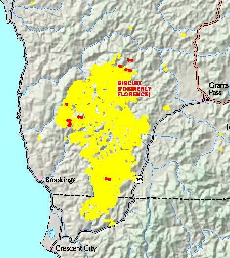
The Biscuit Fire stood at 435,654 acres Sunday and was 35 percent contained. The fire is the largest in Oregon in a century and is the biggest in the United States.
The fire in southwest Oregon and northern California covers an area about five times the size of the Portland-metro area, said David Widmark, spokesman for the Northwest Interagency Coordination Center in Portland.
On the southwest portion of the fire, crews continued to deal with a a 1,000-acre spot fire that ignited late Friday near the Chetco and Pistol river and could head into the river drainage system.
Residents along the upper Chetco River and upper Pistol River were put on alert earlier in the week in case they had to evacuate.
)
An evacuation notice for 17,000 residents in the Illinois Valley was lifted Friday, and pre-evacuation notices were still in effect Sunday for residents of the communities of Agness, Illahe, Wilderness Retreat and the upper Pistol River drainage.
Other Oregon Fires
Other fires burning around Oregon include:
-- the Tiller Fire Complex, which had burned 53,900 acres and was 43 percent contained.
-- the Monument-Malheur Complex, which had burned 44,062 acres and was 97 percent contained.
-- the Mount Marion fire, which had burned 100 acres six miles southeast of Marion Forks.
-- the Apple fire, 21 miles east of Glide, had burned 5,000 acres by Sunday morning. Three campgrounds were closed, as were the Umpqua Trail and portions of the North Umpqua River.
-- the Suislaw River fire, 15 miles southwest of Veneta, started Saturday and had burned 400 acres by Sunday.
To: Grampa Dave
But it has burned about 400 acres of old and second-growth trees owned by the Bureau of Land Management and the private timber firm Roseburg Forest Products.I thought the green jihadists taught us that OLD growth trees were fire resistant.
Thanks for the update Dave.
To: All
The official fire map put on 16 August from data points of 15 August.
The entire Kalmiopsis Wilderness Area has basically been burnt, is burning and will burn.
Expect the Green Jihadists's Fire is Good, Fire Ecologists to start their Bravo Sierra about how good this good fire really was for the wilderness that was burnt up.

To: All
Latest Noah satellite picture of the Oregon is Still Burning fires:

To: Grampa Dave
To: Grampa Dave
Are you a current Oregonian. Just curious.
To: Grampa Dave
By Kent Gray
Triplicate staff writer
Fire officials have acknowledged a request was made to attempt to extinguish the Biscuit Fire when it was only 100 acres, but that request was turned down.
"They offered to make one run on the fire to do bucket work for one fuel cycle," said Paul Galloway, information officer for the Biscuit Fire said. "But management didn't believe that would be helpful. There were no ground crews to take advantage of it and it would have had minimal effect."
Del Norte County Supervisor Chuck Blackburn said yesterday the helicopter crew believed it could have made an impact.
"The helicopter offered to try and make an impact and they were told no," said Blackburn. "... I can't say for sure. Maybe it couldn't have been put out. But I've been talking to people who should know, and the people I have talked to said it could have, and should have, been put out."
Blackburn, who said he will not reveal the names of those who have confided in him, said he has been analyzing the fire response for two weeks and has come to the conclusion more could have been done.
"I think there was a problem between the regions and getting permission to go in and put the fire out," he said. "I'm not after people's names or pointing fingers. I just want to make sure that regions don't become a problem, the stateline doesn't become a problem, so years down the road when this reoccurs we don't have a problem."
The incident with the California Department of Forestry helicopter occurred on July 14, one day after the Sour Biscuit Fire was ignited by a lightning strike in the Siskiyou National Forest. Galloway said the fire, centered in a remote and roadless section of forestland, was reportedly 100 acres in size at that time.
The Biscuit Fire was one of "hundreds" that sparked throughout Oregon around the same time, Galloway said. Because of this, resources were stretched thin on July 13 and no crews were assigned to the Sour Biscuit blaze until July 14, and those crews basically attempted to make roads into the area.
The first report of the Biscuit blaze was received at 3:15 p.m. from a fixed-wing reconnaissance flight in the area. At 3:50 p.m., another blaze was spotted at Carter Creek.
"There was confusion whether or not there were two fires at first," said Galloway. "Folks from the Six Rivers National Forest also saw smoke in the area and reported it. It was determined later there was only one fire (in the Biscuit area)."
Rick Addy, the federal manager for the Six River National Forest, said interstate fire response is common, with some exceptions.
"The closest forces will respond to a fire, like with a lightning strike, and after the initial attack they take care of theirs and we take care of ours," Addy said. "Except for aircraft. They have to be coordinated because it's not safe to mix aircraft. There's a real safety issue involved."
Galloway said there was no aircraft assigned to the Biscuit blaze on July 14 when the helicopter aid was declined.
Blackburn said an offer from ground crews, with the Gasquet Ranger District in the Six Rivers National Forest, to attack the blaze was also declined in Oregon's Region Six. Galloway said he could find no official mention of this offer.
Galloway said his reports mention no managers' names or offices where the decisions originated from.
Further complications arose with the Sour Biscuit Fire between July 27 and Aug. 1, after the fire entered into California. Blackburn said helicopters were idled in Gasquet while a change of command was being prepared and aircraft communication frequencies were in limbo.
"Nothing was happening here because everything was coming out of Oregon," Blackburn said. He said at 10 a.m. on Aug. 1, he watched opportunities to fight the blaze being squandered because crews were told to wait until 6 p.m.
"They were flying into the Shelley Creek Fire with water and Linda Szczepanik (incident commander of Shelley Creek) was trying to get frequencies released for the Biscuit Fire. I stood there and watched, but she couldn't get the frequencies released. So there's another eight hours lost for Sour Biscuit."
Galloway said it will be at least another week before he can compile a chronology for communications and decisions from fire managers for late July and early August.
Meanwhile, Blackburn said local counties must be proactive if they want to avert similar problems in the future. Blackburn said a meeting is being coordinated for late September between Del Norte County and the Oregon counties of Curry and Josephine to reach agreements with Forest Service Regions Five and Six, the California Division of Forestry, the Oregon Division of Forestry along with local fire officials and legislators.
"We have a good opportunity here to resolve any future problems," said Blackburn. "I'm not calling this meeting to say ‘you screwed up' or ‘he screwed up.' I'm saying ‘What can we do to see that this never happens again?'"
The Sour Biscuit Fire, which eventually burned more than 48,000 acres in Oregon and California, later merged with the larger Florence Fire in Oregon. The combined fire was renamed the Biscuit Fire and is currently responsible for nearly 400,000 acres of scorched forestland.
25 posted on
08/19/2002 10:07:12 AM PDT by
Granof8
To: EBUCK; justshe; glock rocks; AuntB; blackie; dixiechick2000; Granof8; Archie Bunker on steroids; ...
I would like to award this Oregonian reporter, MICHELLE COLE, the Grampa Dave Bravo Sierra Reporter Award for the day re the best story on how good these fires are for nature.
Then, the Fire Worshipping Eco Freak from Humboldt U, Erik Jules, gets the Grampa Dave Bravo Sierra award for the best lies and bad science to justify fire as a good thing. If Erik had his way, we would all gather around a fire, hold hand and chant "Fire is Good!" with zero effective fire fighting. What this vile POS is saying, "Those fire lines, back burning and bull dozing should not have been done. The fire should have been allowed to burn out everyone living in Curry and Josephine County!"
»From The Oregonian
Wildfire News, Adapted to flames, wilderness survives
08/19/02
MICHELLE COLE
concerned about what effects back-burning, bulldozing fire lines and other efforts to control the fire will have on delicate plants and wildlife.
"I'm concerned that the back-burning that was done to build this fire line may have been an incredibly hot back-burn, and that kind of burn may be a stand-replacement burn, where the overstory trees die during the fire," said Erik Jules, a plant ecologist and professor at Humboldt State University who has studied southwest Oregon forests for 10 years.
"We may end up replacing very old trees in a unique ecosystem with an area of highly flammable regrowth much larger than anything that occurred naturally," Jules said.
Diversity in isolation Geologically, the Siskiyou National Forest belongs to one of the oldest regions of Oregon. Fossils found in the area date back at least 200 million years.
Scientists say pieces of the ocean floor were thrust upward onto the continent 140 million years ago, leaving layers of sedimentary rock and serpentine soils rich in iron and magnesium and low in other mineral nutrients.
Geography also plays a key role in the area's biological diversity. The Siskiyou Mountains bridge the Cascade and Coast ranges, connecting four ecological zones. Over time, a highly adapted community of rare plants has taken root, including the Arabis mcdonaldiana, or McDonald's rockcress, an endangered species.
The fire appears to have traveled through areas with rockcress, said Maria Ulloa, a Siskiyou National Forest botanist. But Ulloa said it's unlikely that the fire has destroyed the entire plant population.
The fire's perimeter has covered nearly all of the 179,870-acre Kalmiopsis Wilderness, named for the rare pre-Ice Age shrub Kalmiopsis leachiana. Satellite images indicate that the fire has burned very hot in some areas and left others untouched.
The hot zones include nesting areas of the northern spotted owl. If it continues burning toward the coast, the fire could threaten marbled murrelet habitat.
Some animals will perish, said Lee Webb, forest wildlife biologist for the Rogue River and Siskiyou national forests. But biologists don't expect any species will be lost, he said.
Forest fisheries biologist Dan Delany is also confident the forest's wild coho salmon will survive.
The biggest threat to coho is poor water quality caused by erosion, Delany said. Even as the fire continues to burn, he said, crews are digging ditches to keep sediment from washing into streams off roads built by bulldozers.
"When these fish come back to spawn in October and November, they're going to know it's different," he said. "But I think they'll still spawn in many of the areas. They'll be able to produce young."
Seen it before Besides the area's history of fire and recovery, scientists draw their no-jeopardy conclusions from what they learned the last time a big fire swept through.
The Silver fire began with a lightning strike Aug. 30, 1987. The fire perimeter covered just under 100,000 acres, much smaller than this year's fire but over some of the same landscape.
Lou Gold was camping on Bald Mountain and saw the fire start. He has spent more than 1,000 nights camping in the forest since that fire and has watched the land recover.
Madrone, tanoak and bear grass shoots were visible within weeks of the burn. Spring brought abundant wildflowers, said Gold, the official "storyteller" for the Siskiyou Project, a conservation group that works to protect and restore the Siskiyou's wild rivers. "The basic impression I had was, this was not a catastrophe but it was a phase in a cycle of death and rebirth."
Chris Park, forest hydrologist for the Siskiyou National Forest, said the Silver fire also taught him lessons. "The areas don't all burn the same," he said. "Some burned intense, some moderate and some low. Looking at this current fire, we're seeing that same kind of mosaic."
Ground surveys the first two years after the fire and then 10 years later found no measurable difference in stream water quality, Park said. Although some of the headwaters burned to a crisp, most stream banks remained intact.
Shortly after the fire was out, forest restoration crews planted burned areas with grass seed to prevent soil erosion. But surveys later found that the extent of erosion was little different in reseeded areas compared with areas allowed to revegetate naturally, Park said.
A decade after the fire, tree growth and the return of natural vegetation appeared to have been slower in the areas seeded with grass, Park said, probably because of increased competition for water. In the aftermath of this year's fire, Park said, "we want to take a real good look at where we seed."
The Silver fire was finally declared contained on Nov. 8 -- snuffed out by rain. Forest Service scientists on the Siskiyou think the same thing will happen this year.
This is an example of the Criminally Insane Watermelon Lust for Fire or Fire is Good View of the Green Jihadists whose agendas are burning all over Oregon. They hate us. It is that simple!
To: Grampa Dave
God bless those people, and I pray that their land and homes are safe, as well as themselves.
The western fires are just another testiment to the failure thinking of the radical socialist. The "greens" want the lands returned to nature, the capitalists want the timber protected by a timber industry that watches over it's "crop", and provides timber products for homes and businesses. The "greens" would have the fires burn, but the loggers and timbermen would care for the forrest that is their crop, their livelyhood, and would never let this type of disaster occur in the first place. Sure, forrest fires will always happen, but with the proper management, they can be contained quickly and effectively. I can't believe we have this kind of inferno that could have been prevented by loggers, and timbermen.
There's 50,000 potential homes gone to ash because we have people that don't understand why man was put on this earth. There is ash that could have made furniture, woodwork, barns, feed sheds, all of the things that we need, as a productive people. Now it's just so much burned up ash. It's not about hugging the tree, it's about making something out of it.
45 posted on
08/19/2002 6:11:52 PM PDT by
timydnuc
To: Grampa Dave; 1Old Pro; 68-69TonkinGulfYatchClub; a_federalist; abner; aculeus; alaskanfan; ...
"Oregon is Still Burning, can be the title to this thread until the rains come this fall." Will there still be any Oregon in the fall?
This burn'em out agenda is proceeding much faster than I ever imagined it would. - Soon it will be time to drop the buckets and pick up the bullets.
To: Grampa Dave
Thank a greenie for
all the forest fires and their expansion rate in the Northwest. They are the true leaders in
rural cleansing and will do anything to achieve their objective.
Suggest to my friends to keep up their target practice... the day may come when there is bounty for the miscreants......
How did Foreman, "Tre Arrow" and such dangerous thought ever get introduced into America?
FreeRepublic.com is powered by software copyright 2000-2008 John Robinson