Skip to comments.
Hurricane Debby
NOAA/NHC ^
| 2 August 2024
| NOAA/NHC
Posted on 08/02/2024 2:11:33 PM PDT by NautiNurse
click here to read article
Navigation: use the links below to view more comments.
first previous 1-20 ... 41-60, 61-80, 81-100 ... 261-275 next last
To: NautiNurse
61
posted on
08/03/2024 5:54:27 AM PDT
by
who knows what evil?
(Hospitals are the most dangerous place on Earth! Dr. David Williams)
To: NautiNurse
Upon reading that, one word came to mind.
“Katrina”
62
posted on
08/03/2024 6:05:50 AM PDT
by
FreedomPoster
(Islam delenda est)
To: FreedomPoster
Katrina (2005) was like watching a train wreck in slow motion. We knew for days that the nasty storm had its sights on New Orleans. Unfortunately, the population (including local politicians) could not find their way out of a paper bag with directions.
Hurricane Charley was all hyped for the big, bad, overdue Tampa Bay landfall. Massive evacuations (remarkably smooth process) occurred for St. Pete, Tampa, and the surrounding coastal areas. With the blip of the radar, we watched Charley veer eastward well south of Tampa Bay. Folks who had evacuated inland to Arcadia, Orlando, etc., received a bigger hit from Charley than their coastal homesteads.
63
posted on
08/03/2024 6:23:51 AM PDT
by
NautiNurse
(With a cough and a sputter, the original lying dog-faced pony soldier is led out to pasture. )
To: rodguy911
I’m gonna get a bunch of sand bagsSandbags are limited to 10 per address. ;o)
64
posted on
08/03/2024 6:26:00 AM PDT
by
NautiNurse
(With a cough and a sputter, the original lying dog-faced pony soldier is led out to pasture. )
To: NautiNurse
I would imagine you can buy them if you want....
65
posted on
08/03/2024 7:03:39 AM PDT
by
rodguy911
(HOME OF THE FREE BECAUSE OF THE BRAVE!! ITS ALL A CONSPIRACY: UNTIL ITS NOT))
To: NautiNurse
When I was a boy living in GITMO we had 3-4 hurricanes a year, usually around September. There was nowhere to go. You had to hunker down in your house and use a pushbroom to sweep water out of the house.
One year we got hit by the same hurricane 3 times.
66
posted on
08/03/2024 7:12:27 AM PDT
by
gitmo
(If your theology doesn’t become your biography, what good is it?)
To: NautiNurse
Heres Sand Key near Key West at 10:40 a
air temp.(no water aval.)
83.5 degrees
wind-=-30 knots gust to 34
baro.29.84 dropping
67
posted on
08/03/2024 8:12:03 AM PDT
by
rodguy911
(HOME OF THE FREE BECAUSE OF THE BRAVE!! ITS ALL A CONSPIRACY: UNTIL ITS NOT))
To: abb; abbi_normal_2; aberaussie; abner; AbsoluteGrace; alancarp; Alas Babylon!; Alia; ...
Depression expected to become a Tropical Storm later today
or tonight and strengthen over the SE Gulf of Mexico...
...New watches and warnings issued for portions of FL...
A Hurricane Watch is now in effect for the Florida coast west of
the Aucilla River to Indian Pass.
A Storm Surge Warning is now in effect for the coast of Florida
from Aripeka to the mouth of the Aucilla River.
A Storm Surge Watch is now in effect for the coast of Florida west
of the mouth of the Aucilla River to Indian Pass. 1100 AM EDT Update
-------------------------------
About 40 MI SE of Havana Cuba
About 125 MI S of Key West FL
Max Sustained Winds...35 MPH
Movement...WNW at 15 MPH
Minimum Pressure...1009 MB

On/Off Hurricane List Mash Here--> 
68
posted on
08/03/2024 8:14:01 AM PDT
by
NautiNurse
(With a cough and a sputter, the original lying dog-faced pony soldier is led out to pasture. )
To: All
Wind in Islamorada is 25-30 knots gusting higher,rain on and of on and on off sometimes heavy.
69
posted on
08/03/2024 8:14:43 AM PDT
by
rodguy911
(HOME OF THE FREE BECAUSE OF THE BRAVE!! ITS ALL A CONSPIRACY: UNTIL ITS NOT))
To: rodguy911
Guesstimate you are ~155 miles from the storm center.
70
posted on
08/03/2024 8:37:48 AM PDT
by
NautiNurse
(With a cough and a sputter, the original lying dog-faced pony soldier is led out to pasture. )
To: rodguy911
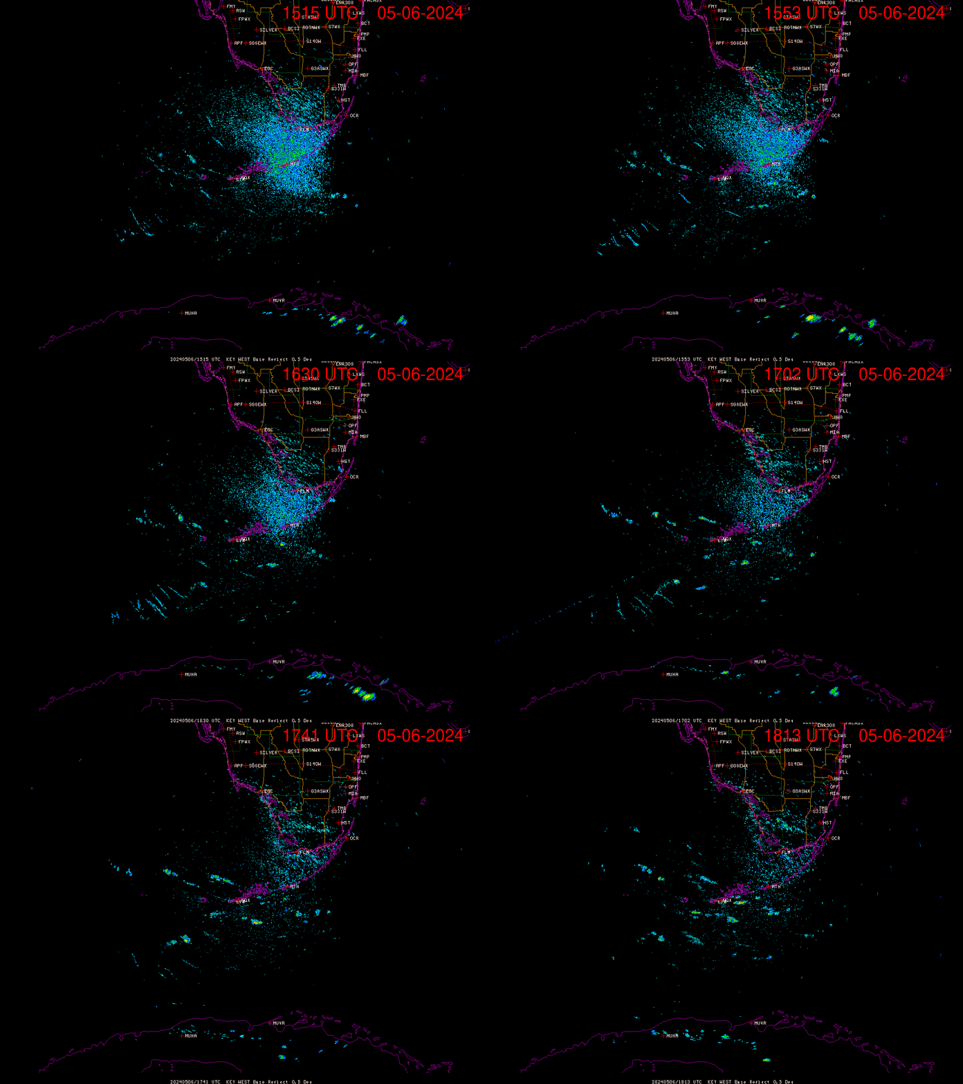
Key West radar. Mash image to enlarge:

71
posted on
08/03/2024 8:51:02 AM PDT
by
NautiNurse
(With a cough and a sputter, the original lying dog-faced pony soldier is led out to pasture. )
To: NautiNurse
All indicators suggesting it won’t have time to get really ‘organized’, but that’s gonna mean a VERY large rainbag with potential for quick spin-up tornados over a wide area.
My own rule of thumb with tropical systems is that they aren’t very interesting until the pressure dips below ~995-1000 mb, and this blob is now at 1009... if they even have the ‘center’ correct.
I suppose the good news is that a bunch of areas on the peninsula currently marked as ‘abnormally dry’ will have that problem resolved this coming week (mostly the Big Bend region and a couple of counties East of Tampa/S. of Lakeland).
72
posted on
08/03/2024 9:09:40 AM PDT
by
alancarp
(George Orwell was an optimist.)
To: NautiNurse
Exactamundo. It’s gonna be interesting to see how quickly this thing grows. Looks like it spans a pretty good area as well. Could be a huge tropical storm or even a #1.
73
posted on
08/03/2024 9:20:52 AM PDT
by
rodguy911
(HOME OF THE FREE BECAUSE OF THE BRAVE!! ITS ALL A CONSPIRACY: UNTIL ITS NOT))
To: NautiNurse
thanks,this thing is getting more impressive all the time!
74
posted on
08/03/2024 9:22:06 AM PDT
by
rodguy911
(HOME OF THE FREE BECAUSE OF THE BRAVE!! ITS ALL A CONSPIRACY: UNTIL ITS NOT))
To: alancarp
What are the steering current like?Is this storm likely to stall or keep a pretty good forward speed all the way to land?
75
posted on
08/03/2024 9:24:16 AM PDT
by
rodguy911
(HOME OF THE FREE BECAUSE OF THE BRAVE!! ITS ALL A CONSPIRACY: UNTIL ITS NOT))
To: rodguy911
Squall line passing through Tampa Bay area.
76
posted on
08/03/2024 9:55:45 AM PDT
by
NautiNurse
(With a cough and a sputter, the original lying dog-faced pony soldier is led out to pasture. )
To: rodguy911
Consistent speed until it slows a bit approaching the Florida coast... at least that’s the forecast, but as big as this is, it could be an 18-24 hr event for some.
77
posted on
08/03/2024 10:15:52 AM PDT
by
alancarp
(George Orwell was an optimist.)
To: alancarp
Thanks very much 18-24 would not be good.
78
posted on
08/03/2024 11:20:30 AM PDT
by
rodguy911
(HOME OF THE FREE BECAUSE OF THE BRAVE!! ITS ALL A CONSPIRACY: UNTIL ITS NOT))
To: All
Our gusts are getting stronger here,hard to say what the number is.
79
posted on
08/03/2024 11:24:51 AM PDT
by
rodguy911
(HOME OF THE FREE BECAUSE OF THE BRAVE!! ITS ALL A CONSPIRACY: UNTIL ITS NOT))
To: rodguy911; All
Unusual interim update for watches and warnings…
BULLETIN
Tropical Depression Four Intermediate Advisory Number 5A
NWS National Hurricane Center Miami FL AL042024
200 PM EDT Sat Aug 03 2024
...DEPRESSION STARTING TO MOVE INTO THE SOUTHEASTERN GULF OF
MEXICO...
...TROPICAL STORM WARNING ISSUED FOR PORTIONS OF THE FLORIDA KEYS...
SUMMARY OF 200 PM EDT...1800 UTC...INFORMATION
LOCATION...23.1N 82.6W
ABOUT 15 MI...25 KM WNW OF HAVANA CUBA
ABOUT 115 MI...185 KM SSW OF KEY WEST FLORIDA
MAXIMUM SUSTAINED WINDS...35 MPH...55 KM/H
PRESENT MOVEMENT...WNW OR 300 DEGREES AT 15 MPH...24 KM/H
MINIMUM CENTRAL PRESSURE...1009 MB...29.80 INCHES
WATCHES AND WARNINGS
CHANGES WITH THIS ADVISORY:
A Tropical Storm Warning is now in effect for the Florida Keys from
the Seven Mile Bridge westward.
80
posted on
08/03/2024 11:43:34 AM PDT
by
NautiNurse
(With a cough and a sputter, the original lying dog-faced pony soldier is led out to pasture. )
Navigation: use the links below to view more comments.
first previous 1-20 ... 41-60, 61-80, 81-100 ... 261-275 next last
Disclaimer:
Opinions posted on Free Republic are those of the individual
posters and do not necessarily represent the opinion of Free Republic or its
management. All materials posted herein are protected by copyright law and the
exemption for fair use of copyrighted works.
FreeRepublic.com is powered by software copyright 2000-2008 John Robinson


