Posted on 08/02/2024 2:11:33 PM PDT by NautiNurse
Tropical Storm watches and warnings have been issued from the Florida Keys up the Florida Gulf Coast to Suwanee. The system is crossing Central Cuba, moving at 16mph. The disturbance is expected to develop into a tropical depression on Saturday as it moves across the Straits of Florida, followed by intensification into a tropical storm by Saturday night. Governor DeSantis declared a state of emergency for 54 counties, most along the Gulf Coast and in northern Florida, to move assets in preparation for the storm.
August 13 marks 20 years since Hurricane Charley made landfall near Punta Gorda FL.
The rapid strengthening of Charley in the eastern Gulf of Mexico caught many by surprise. Around five hours before its Florida landfall, Charley was a strong Category 2 hurricane predicted to strengthen its strongest winds to 115 mph upon its landfall in the Tampa–Saint Petersburg area. About two hours before landfall, the National Hurricane Center issued a special advisory, notifying the public that Charley had become a 145 mph Category 4 hurricane, with a predicted landfall location in the Port Charlotte area. As a result of this change in forecast, numerous people in the Charlotte County area were unprepared for the hurricane, although the new track prediction was well within the previous forecast's margin of error. National Hurricane Center forecasting intern Robbie Berg publicly blamed the media for misleading residents into believing that a Tampa landfall was inevitable.
Mash the graphics below to enlarge. All links and images are self-updating.
Tropical Tidbits by Levi Cowan
Local News:
FOX4 News Southwest Florida
WWSB Sarasota/Bradenton
WFLA Tampa Bay
WESH2 Orlando
1100 PM EDT Update
-------------------------------
About 75 MI S of Caibarien Cuba
About 260 MI SSE of Key West FL
Max Sustained Winds...30 MPH
Movement...WNW at 17 MPH
Minimum Pressure...1010 MB
Tropical Depression Four Discussion Number 3
NWS National Hurricane Center Miami FL AL042024
1100 PM EDT Fri Aug 02 2024
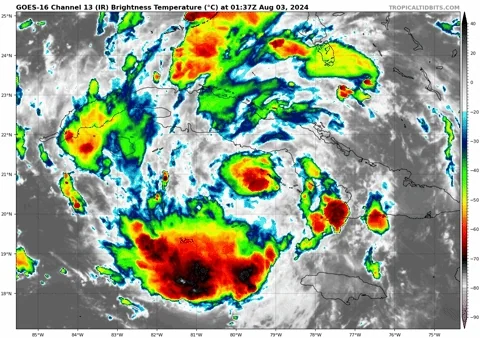
Shortwave infrared satellite imagery, Cuban radar data, and surface
observations from Cuba and the Cayman Islands suggest that the
disturbance has developed a closed circulation, and the center is
located just off the south coast of Cuba. Deep convection is still
a bit fragmented, but there has been a persistent burst near the
estimated center since earlier this afternoon. The wind and
pressure field could still be a little elongated within the
southern semicircle, but overall the system appears to have enough
organization to now be designated as a tropical depression. The
initial intensity remains 25 kt based on earlier observations.
The depression has not begun to turn yet, and the initial motion is
west-northwestward, or 285/15 kt. A turn toward the northwest and
then north is expected over the weekend due to a break in the
subtropical ridge caused by a trough over the eastern United
States. Since the system has not started to turn yet, this has
caused all of the track guidance to shift west, and the updated NHC
forecast is a bit west of the previous forecast along the eastern
edge of the main cluster of models. It is important to note that
because of the forecast track being parallel to the west coast of
Florida, the location and timing of a potential landfall cannot be
pinned down at this time. One additional significant change to the
forecast is that the models seem to be showing the aforementioned
trough leaving the cyclone behind early next week, which causes a
much slower motion while the system is near the coasts of Georgia
and South Carolina. As a result, the new NHC forecast is notably
slower than the previous forecast, particularly on days 4 and 5.
The westward shift to the track forecast now also keeps the system
over the warm waters of the Gulf of Mexico longer, giving the
system additional time to potentially strengthen. In fact, the
SHIPS guidance and all of the regional hurricane models show the
cyclone reaching hurricane strength before reaching land in the Big
Bend region of Florida in 2 to 3 days. As a result, the new NHC
forecast brings the intensity to 60 kt at 60 hours as the system is
reaching land, but if model trends continue, it’s possible that
future forecasts could explicit show the system becoming a
hurricane before it reaches land. The intensity forecast is more
uncertain on days 3 through 5 due depending on if the center moves
back offshore or stays inland over the southeastern United States

Present!
This entire area (Savannah, GA and lowcountry coastal South Carolina) does NOT need more rain. There's been an awful lot of flooding...
We are actually heading back north just for a couple of weeks. We were going to leave this area on either Monday or Tuesday. It's never fun to travel through tropical-like downpours with limited visibility. We're trying to decide if travel on Monday, Tuesday or Wednesday might be best...
Wouldn’t ya know it... a big bullseye on South Carolina! Ugh..
Believe it or not, the local news meteorologists in the Hartford and New Haven, CT areas often talked about microbursts. I can't remember if they were referring to summer or winter storms though, lol.
Snow squalls are kind of a microburst, I think. Snow squalls are horrible and often deadly if you're driving on a highway, but no big deal if you're just sitting inside looking out at one.
A HUGE mega-dittos to that! :-)
LOL!
Arcadia is watching.
500 AM EDT Update
-------------------------------
About 80 MI SSE of Varadero Cuba
About 195 MI SSE of Key West FL
Max Sustained Winds...30 MPH
Movement...WNW at 16 MPH
Minimum Pressure...1009 MB
Hope there isn’t a repeat of Idalia’s flooding in the Homosassa area. We spent a couple of nights there back in March - one of the last “Old Florida” places remaining. We were impressed with the wildlife park.
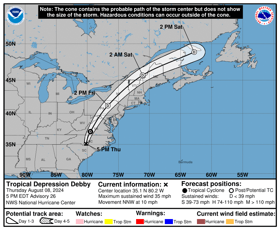
After landfall, weakening steering currents should cause the cyclone to slow
down while it moves northeastward over parts of northern Florida and
Georgia. Thereafter, the track forecast becomes highly uncertain as it is
unclear whether the system will accelerate northeastward ahead of an upper
trough (GFS) or get left behind and meander over the southeastern U.S. or
near the coast (ECMWF).
looks lke we doged it this time and so will you,still remains to see what the steering currents and sheer does to this or will it stall along the way.All that can effect the strength.
We are a long way from seeing how big this thing can get.
Down here we are good at cleaning u after storms,finallllly,so we were read y for most anything and got a pass
I don't recall what month I experienced that microburst. It had to be cooler weather (by FL standards), because my french doors to the lanai were open. That was crazy watching the trees and shrubs flatten toward the earth as the rain drove deep into my kitchen.
Just received txt msg that sand bags are available for pick up today until noon.
You make an excellent point. Convection and rotation around the storm is huge, spanning both north and south of Cuba.

Also, the slow turn from WNW to N and even NNE takes it further from the coast. But, even than there is no guarantee where it will wind up.
Nature can amaze all of us with how strong it gets.
If we get a big one down here I’m gonna get a bunch of sand bags,they can avoid all kinds of damage to inside the house.
Disclaimer: Opinions posted on Free Republic are those of the individual posters and do not necessarily represent the opinion of Free Republic or its management. All materials posted herein are protected by copyright law and the exemption for fair use of copyrighted works.