Hurricane Laura taking aim at the NW Gulf of Mexico coast.
Navigation: use the links below to view more comments.
first previous 1-20, 21-40 last
To: abb; abbi_normal_2; aberaussie; abner; AbsoluteGrace; alancarp; Alas Babylon!; Alia; ...
Laura Expected to Rapidly Strengthen to Category 4...500 AM EDT Update
Location...About 315 MI SSE of Lake Charles LA
...About 335 MI SE of Galveston TX
Max Sustained Winds...110 MPH
Moving...NW at 15 MPH
Minimum Pressure...973 MB
Hurricane-force winds extend outward up to 70 miles from the center
and tropical-storm-force winds extend outward up to 175 miles

On/Off Hurricane List Mash Here--> 
149 posted on
08/26/2020 2:19:31 AM PDT by
NautiNurse
(Trumptilla MOAB--Mother of All Boat Parades--Clearwater FL, 8-15-2020)
To: NautiNurse; Admin Moderator
Admin Moderator, can we get this thread pinned to Breaking News as the Live Thread?
162 posted on
08/26/2020 4:53:58 AM PDT by
GreenLanternCorps
(Hi! I'm the Dread Pirate Roberts! (TM) Atsk about franchise opportunities in your area.)
To: NautiNurse
I thank you NautiNurse for doing these threads.
And I thank God this hurricane is not coming my way. Here in Delaware we had a helluva time with that recent tropical storm with the oddball name.
I am older and now terrified by hurricanes.
170 posted on
08/26/2020 5:39:52 AM PDT by
Fishtalk
(https://patfish.blogspot.com/2020/08/pandemic-2020-update-81920-conventions.html)
To: NautiNurse
https://abc13.com/lake-charles-buses-leave-with-evacuees-before-lauras-arrival/6389383/
Authorities in Lake Charles didn’t wait to order everyone out of the area. Mandatory evacuations were ordered Tuesday for Calcasieu Parish, which impacted more than 200,000 residents. Neighboring Cameron Parish to the south is also under a mandatory order.
As the populations of Calcasieu and Cameron Parishes began to leave, those who couldn’t get out on their own took a bus.
To: NautiNurse
https://www.calcasieuparish.gov/services/emergency-home-page/-backlist-/
Aug. 25, 2020 – The Calcasieu Parish Executive Policy Group has issued a Mandatory Evacuation, effective immediately, for Calcasieu Parish residents due to the anticipated effects of Hurricane Laura.
Laura is expected to make landfall late Wednesday night or early Thursday morning as a Category 3 hurricane, with winds higher than 100 mph and storm surges of 9-13 feet.
In addition, a dusk-to-dawn (7 p.m.-6 a.m.) curfew has been established beginning Wednesday until it is deemed safe to lift it. The curfew affects all residents, except those who are considered essential personnel. Essential employees should have their work IDs with them at all times.
To: NautiNurse
always watch the east side of the storms..
To: abb; abbi_normal_2; aberaussie; abner; AbsoluteGrace; alancarp; Alas Babylon!; Alia; ...
Laura Continues to Strengthen and is Expected to Become an
Extremely Dangerous Category 4 Hurricane...1100 AM EDT Update
Location...About 225 MI SSE of Lake Charles LA
...About 235 MI SE of Galveston TX
Max Sustained Winds...125 MPH
Moving...NW at 16 MPH
Minimum Pressure...956 MB
Hurricane-force winds extend outward up to 70 miles from the center
and tropical-storm-force winds extend outward up to 175 miles
The storm surge could penetrate up to 30 miles inland from the
immediate coastline in southwestern LA and far southeastern TX.
Hurricane-force winds and damaging wind gusts are also expected
to spread well inland into portions of eastern Texas and western
Louisiana early Thursday.
On/Off Hurricane List Mash Here-->
195 posted on
08/26/2020 7:59:12 AM PDT by
NautiNurse
(Trumptilla MOAB--Mother of All Boat Parades--Clearwater FL, 8-15-2020)
To: abb; abbi_normal_2; aberaussie; abner; AbsoluteGrace; alancarp; Alas Babylon!; Alia; ...
Category 4 Hurricane Laura...Extremely Dangerous...
...Catastrophic Storm Surge, Extreme Winds, and Flash Flooding
Expected Along the NW Gulf Coast Tonight...200 PM EDT Update
Location...About 200 MI SSE of Lake Charles LA
...About 200 MI SSE of Galveston TX
Max Sustained Winds...140 MPH
Moving...NW at 16 MPH
Minimum Pressure...952 MB
Hurricane-force winds extend outward up to 70 miles from the center
and tropical-storm-force winds extend outward up to 175 miles
On/Off Hurricane List Mash Here-->
274 posted on
08/26/2020 10:45:14 AM PDT by
NautiNurse
(Trumptilla MOAB--Mother of All Boat Parades--Clearwater FL, 8-15-2020)
To: NautiNurse
Prayers sent for everyone in the Lake Charles, LA area and the Texas border..Laura is a MONSTER now a CAT 4, prayers sent for everyone in the path
To: NautiNurse
At least it’s a mostly peaceful hurricane
280 posted on
08/26/2020 11:05:31 AM PDT by
wolfman
To: NautiNurse
Well, this should sweep out the bulk of nutria in SouthWest Louisiana, but the ones left breed fast.
To: NautiNurse
Storm looks to be taking the northern turn towards the pole.
It’s that wobbling “biting the nails” time. Hopefully everyone in the coastal area and marshes got out of town. As you pointed out, the topography of location + strength/size of storm = a 30 mile storm surge. Pray everyone got out of there.
To: abb; abbi_normal_2; aberaussie; abner; AbsoluteGrace; alancarp; Alas Babylon!; Alia; ...
Wind and Water Levels Increasing As Extremely Dangerous
Hurricane Laura Takes Aim at the NW Gulf Coast...
...Catastrophic Storm Surge, Extreme Winds, and Flash Flooding
Expected Along the NW Gulf Coast Tonight...500 PM EDT Update
Location...About 155 MI SSE of Lake Charles LA
...About 155 MI S of Galveston TX
Max Sustained Winds...145 MPH
Moving...NW at 15 MPH
Minimum Pressure...947 MB
Hurricane-force winds extend outward up to 60 miles from the center
and tropical-storm-force winds extend outward up to 205 miles
On/Off Hurricane List Mash Here-->
341 posted on
08/26/2020 1:54:45 PM PDT by
NautiNurse
(Trumptilla MOAB--Mother of All Boat Parades--Clearwater FL, 8-15-2020)
To: NautiNurse
Thanks for compiling the links
396 posted on
08/26/2020 4:03:29 PM PDT by
a fool in paradise
(Joe Biden- "First thing I'd do is repeal those Trump tax cuts." (May 4th, 2019))
To: NautiNurse
Paying for those in her path.....Storm be still In Jesus name
431 posted on
08/26/2020 5:09:33 PM PDT by
blueyon
(`nt to be a nothing burger)
To: abb; abbi_normal_2; aberaussie; abner; AbsoluteGrace; alancarp; Alas Babylon!; Alia; ...
Extremely Dangerous Hurricane Laura Closing In On the NW Gulf Coast...
...Catastrophic Storm Surge, Extreme Winds, and Flash Flooding
Expected Along the NW Gulf Coast Tonight & Early Thursday...
1100 PM EDT Update Location...About 75 MI S of Lake Charles LA
...About 75 MI SE of Port Arthur TX
Max Sustained Winds...150 MPH
Moving...NNW at 15 MPH
Minimum Pressure...939 MB
Hurricane-force winds extend outward up to 60 miles from the center
and tropical-storm-force winds extend outward up to 205 miles
On/Off Hurricane List Mash Here-->
494 posted on
08/26/2020 7:58:24 PM PDT by
NautiNurse
(Trumptilla MOAB--Mother of All Boat Parades--Clearwater FL, 8-15-2020)
To: NautiNurse
503 posted on
08/26/2020 8:06:43 PM PDT by
central_va
(I won't be reconstructed and I do not give a damn...)
To: abb; abbi_normal_2; aberaussie; abner; AbsoluteGrace; alancarp; Alas Babylon!; Alia; ...
Damaging Winds and Flooding Rainfall Spreading Inland Over Western
and Central LA...
...Life-Threatening Storm Surge Continues Along Much of the LA Coast...
800 AM EDT Update Location...About 20 MI N of Fort Polk LA
Max Sustained Winds...100 MPH
Moving...N at 15 MPH
Minimum Pressure...970 MB
Hurricane-force winds extend outward up to 60 miles from the center
and tropical-storm-force winds extend outward up to 175 miles
On/Off Hurricane List Mash Here-->
598 posted on
08/27/2020 5:26:29 AM PDT by
NautiNurse
(Trumptilla MOAB--Mother of All Boat Parades--Clearwater FL, 8-15-2020)
To: NautiNurse
TXnMA Update -- 1PM Thursday:
We "dodged the bullet": Laura veered off to the east of Shreveport, LA -- and, will cross into Arkansas before long.
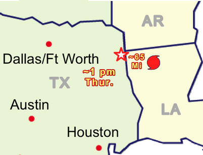
We had steady winds 30-35 mph -- gusting to 45-50 (based on tree sounds & swaying of treetops). They are now out of the NNW, and diminishing...
We had a few power flickers about noon, but the only "casualty" so far was my wife's umbrella -- which she left open on the porch. I had to go retrieve it (with a few bent ribs) about 100' away.
We had less rain than we normally have with a single strong T'storm. (Just added to the water I put in the canoe to keep it from becoming airborne...)
All in all, anticipation was worse than actual...
TXnMA

641 posted on
08/27/2020 11:12:36 AM PDT by
TXnMA
(Anagram: "PANDEMIC --> DEM PANIC")
To: NautiNurse
NautiNurse,
Thank you for yet another informative and comprehensive hurricane thread. You are truly a national asset.
664 posted on
08/27/2020 7:28:56 PM PDT by
Natty Bumppo@frontier.net
(We are the dangerous ones, who stand between all we love and a more dangerous world.)
Navigation: use the links below to view more comments.
first previous 1-20, 21-40 last
FreeRepublic.com is powered by software copyright 2000-2008 John Robinson